

Permit/License Number
12-03-2023
Excavation Report
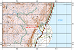
During April–May 2023, an excavation was conducted on the northern bank of Naḥal Qidron (Archaeology C.G.A.T. License No. 12-03-2023; map ref. 24119/620828; Fig. 1). The excavation was undertaken as part of the Judean Desert Caves Survey Project, on behalf of the Archaeological Staff Officer of Judea and Samaria, the Israel Antiquities Authority and the Heritage Department in the Prime Minister’s Office. It was directed by M. Toldano (drafting, graphics and photogrephy) and E. Klein (drafting, graphics, aerial photography, Processing and photographing the coins), with the assistance of O. Amichay, H. Hamer, G. Derech, A. Ganor, I. Hadad and Y. Pagis (survey and excavation team).
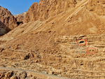
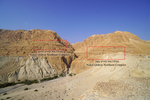
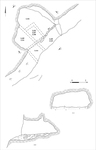
A cave (U3-016) and a building (SPU3-19/8) were excavated on the cliff of the northern bank of Naḥal Qidron (c. 238 m below sea level; Fig. 2) at the stream’s outlet into the Dead Sea Rift, about 1 km west of Khirbat Mazin. The cave and building are part of an extensive site known as the ‘Naḥal Qidron Northern Complex ’ (Fig. 3), which comprises several caves and crevices and numerous architectural remains connected by a network of paths. Most of the architectural remains abut low cliffs or detached boulders. The Naḥal Qidron Northern Complex was previously surveyed by P. Bar-Adon, who called it ‘Kafr Wadi en-Nar’ (Bar-Adon 1972:126). Bar-Adon drafted a site plan and collected pottery dated to the Iron Age and the Roman and Byzantine periods. In Bar-Adon’s field diaries, Cave U3-016 was recorded as Cave A641, and Building SPU3-19/8 was recorded as Building A639. U. Davidovich reexamined the pottery collected during Bar-Adon’s survey and suggested that some should be dated to the Early Roman and Byzantine–Early Islamic periods. Davidovich also identified a cluster of temporary structures scattered throughout the complex, forming a ‘cell site,’ a term used to describe a site formed from many small built cells. He proposed that these were hermitages used during the Early Roman or Byzantine periods or that they were used by rebels during the Roman period (Davidovich 2014:169–170).
Opposite the ‘Naḥal Qidron Northern Complex’ and at the same elevation, a similar site, known as the ‘Naḥal Qidron Southern Complex’ (see Fig. 3) was found on the cliff of the southern bank of Naḥal Qidron. In this complex, crevices, small caves, paths and built cells were discovered near small cliffs, bedrock benches and boulders. Bar-Adon was the first to survey this site (1972:125), and it was later extensively surveyed as part of ‘Operation Scroll.’ Pottery from the Early Roman and Byzantine periods was found during the survey as well as coins, including a coin of Agrippa I, 19 coins from the second year of the Great Revolt, three coins from the third year of the Great Revolt and ten Byzantine coins. Based on these finds, it was suggested that the site was occupied by Jewish refugees during the Great Revolt, and it later served as a hermitage during the Byzantine period (Dahari 2002:231–241).
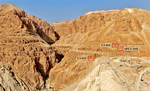
During 2021, the ‘Naḥal Qidron Northern Complex’ was surveyed as part of the Judean Desert Caves Survey Project, and large pottery and coin assemblages were collected. Seven bronze coins from the Roman and Hellenistic periods were found during the survey in Cave U3-016, and most of them were dated to the Great Revolt (see below). A thick accumulation formed from human activity was identified on the floor of the cave and excavated. Pottery dated to the Chalcolithic period, Iron Age and Hellenistic, Early Roman and Byzantine periods was found. Excavations also uncovered a few flint and bone tools, a bead and a bronze coin dated to the second year of the Great Revolt. Additionally, in the center of the cave, there were four hearths. Another coin from the Great Revolt was found in a nearby cave (U3-015; Fig. 4). Building SPU3-19/8 was built on a bedrock terrace below the cave (242 m below sea level). The excavation of the building yielded a few undiagnostic pottery sherds and a Byzantine-period iron pin. The ‘Naḥal Qidron Southern Complex’ was not excavated as part of the expedition.
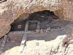
Cave U3-016 (Figs. 5, 6). The entrance to the cave (width 5 m, height 2 m) is located at the center of the cliff and is visible from a considerable distance. The cave has a single rounded and wide cavity (max. dimensions 6 × 5 m), and it is well ventilated and comfortable. At the entrance to the cave, there is a wall constructed of a single course of large and medium-sized stones (W1; length 3 m). The wall was only preserved along the center of the cave entrance, but it likely originally spanned the entirety of the cave entrance; it delineated the cave and maintained a leveled floor. Several stones were exposed c. 0.15 m beneath the wall, perhaps representing an earlier wall. The absence of finds prevented dating these walls.
Five excavation squares of various sizes were opened inside the cave. A surface layer of soft light brown soil mixed with stones that fell from the ceiling was uncovered at the entrance of the entrance, south of W1 (L105, L114, L115) and inside the cave (L101 and L109). In this layer, a small area of twigs was found (L103; diam 0.4 m, thickness 0.1 m)—possibly the remains of an earlier surface. This surface layer slopes eastward and its thickness varies; in the western part, the thickness is c. 0.1 m and in the eastern part, at the entrance, the thickness is c. 0.5 m. Finds recovered from the floor include pottery from the Chalcolithic period, the Iron Age and the Hellenistic, Roman and Byzantine periods as well as textiles, stone artifacts and tools, flint items, bones, a bead, shells, two modern metal balls and a coin from the second year of the Great Revolt (from the bottom of L114). In the center of the cave, a probe was conducted beneath a large boulder that probably fell from the ceiling; the probe uncovered light brown soil mixed with small stones and patches of yellow sand that contained several flint artifacts and no pottery. In the lower part of the probe, excavations uncovered a yellowish sandy soil, which is part of a geological layer. On a bedrock terrace c. 3 m below the cave, there was a pile of soil (depth c. 0.3 m) that was removed from the cave probably during looting. Pottery sherds from the Hellenistic and Roman periods were found within the pile.
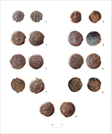
The coins found in the cave during they survey and excavation include eight bronze coins: one from the reign of Antiochus IV (Fig. 7:1; Cat. No. 47445), one from the reign of Herod/Herod Archelaos (Fig. 7:2; Cat. No. 47446), five from the second year of the Great Revolt (67 CE; Fig. 7:3–7; Cat. No. 47447–47451) and one from the third year of the Great Revolt (68 CE; Fig. 7:8; Cat. No. 47452). A bronze coin dated to the third year of the Great Revolt (68 CE; Fig. 7:9; Cat. No. 47442) was also found nearby in Cave U3-015 during the survey of the ‘Naḥal Qidron Northern Complex.’
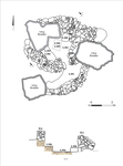
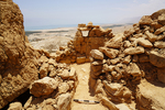
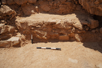
Building SPU3-19/8 (max. dimensions 4 × 8 m; Figs. 8, 9) is located about 15 m from Cave U3-016 and slightly lower on the slope. Once the stones that covered the building were removed, its layout was clarified. The building is small and approximately triangular, containing two rooms (L301, L302). Its walls (W3–W6) were built of fieldstones of various sizes between three large boulders; the walls were preserved to a maximum height of 1 m. A tamped-earth floor was found in the building. A narrow entranceway was set in W5, which divides the two rooms. The entrance to the building may have been in W3, although this could not be ascertained during the excavation. Two benches were found inside Room 302; one (L307) was a low row of stones that adjoined the eastern boulder, and the other (L306; length c. 1.6 m, width c. 0.8 m, height c. 0.4 m; Fig. 10) was dry constructed of small stones that adjoined W4 and was perhaps used as a bed. The floor of the room abuts both benches. Wall 6, which delineates Room 301, is curved. Meager finds were recovered from the building; they include two Byzantine-period pottery sherds and an iron pin that was found in Room 301 and dated to the Byzantine period.
The finds from Cave U3-016 reveal traces of human activity during the Chalcolithic period, the Iron Age and the Hellenistic, Roman and Byzantine periods. Nevertheless, the numismatic assemblage indicates intensive activity during the Early Roman period and the Great Revolt in particular. These coins parallel those previously found in the ‘Naḥal Qidron Southern Complex,’ and combined, there are 29 bronze coins dated to the Great Revolt. This is the largest coin assemblage from this period in the Judean Desert caves. It reflects the importance and central position of the Naḥal Qidron outlet into the Dead Sea, near the road that passes from the northern Judean Desert, through the area of Ras Feshkha to ‘En Gedi (Porat 2006:5–22). It is also possible that following the Roman conquest of the northern Judean Desert and the destruction of the sect center at Qumran in 68 CE, the cave was used as a temporary shelter near the anchorage at Khirbat Mazin or as a refuge for those who fled from Jerusalem to Naḥal Qidron.
Few Byzantine-period finds were discovered during the excavation of Building SPU3-19/8. The architectural features of the building may indicate that like other buildings in the ‘Naḥal Qidron Northern Complex,’ it was used by hermit priests during the Byzantine period. If the building was indeed a hermitage, then the large northern room may have been used as a living area, while the smaller southern room, facing approximately east, was used as a prayer room. Based on the Byzantine remains in the ‘Naḥal Qidron Northern Complex,’ which are similar to the ones found in the nearby ‘Naḥal Qidron Southern Complex’ (Dahari 2002), the cave and building uncovered in this excavation join previously identified hermitage sites in the cliffs of the northern Judean Desert used by priests during Byzantine period (Davidovich and Porat 2019).
References
Bar-Adon P. 1972. The Judaean Desert and Plain of Jericho. In M. Kochavi ed. Judaea, Samaria and the Golan. Archaeological Survey, 1967–1968. Jerusalem. Pp. 91–149 (Hebrew).
Dahari U. 2002. Region XIV: Survey and Excavations of Caves along the Fault Escarpment from Naḥal Kidron to Naḥal Deragot. ‘Atiqot 41/1:231–247 (Hebrew). https://doi.org/10.70967/2948-040X.2574
Davidovich U. 2014. The Judean Desert during the Chalcolithic, Bronze and Iron Ages (Sixth–First Millennia BCE): Desert and Sown Relations in Light of Activity Patterns in a Defined Desert Environment. Ph.D. diss. The Hebrew University. Jerusalem (Hebrew; English abstract).
Davidovich U. and Porat R. 2019. Hermitages along the Dead Sea Escarpment: Archaeological, Geographical and Historical Exploration. In O. Peleg-Barkat, J. Ashkenazi, U. Leibner, M. Aviam and R. Talgam eds. Between Sea and Desert: On Kings, Nomads, Cities and Monks. Essays in Honor of Joseph Patrich. Ẓemaḥ. Pp. 211*–231* (Hebrew).
Porat R. 2006. The Road along the Dead Sea Shore between Qumran and Ein-Gedi in the Second Temple Period. Cathedra: For the History of Eretz Israel and Its Yishuv 121:5–22 (Hebrew; English abstract, p. 203).
Keywords
Kidron Valley, Judean Desert, Caves, Great Revolt, Early Roman period, Byzantine period, Bronze coins, Khirbet Mazin, Cell sites, Caves
Publication Date
19/11/2026
Report Type
Final Report
Included in
Classical Archaeology and Art History Commons, History of Art, Architecture, and Archaeology Commons