El‘ad (A-8478)
Permit/License Number
A-8478
Excavation Report
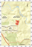
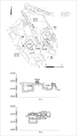
During March–April 2019, a salvage excavation was conducted on the northeastern edge of the town of El‘ad (Permit No. A-8478; map ref. 196861–7291/662248–853; Fig. 1), prior to building a residential neighborhood. The excavation, on behalf of the Israel Antiquities Authority and financed by the Ministry of Housing, was directed by J. Marcus, with the assistance of N. Shachar and A. Umanski (area supervision), Y. Amrani and E. Bachar (administration), Y. Shmidov (photogrammetry and surveying), Y. Tepper (scientific guidance), O. Ackermann (geomorphology and pOSL sampling), A. Dagot (GPS), I. Elad and D. Shahar (preliminary inspection), A. Peretz (photography), A. Bar (education guide) and workers from Bir el-Maksur, Shefar‘am, Jenin, the pre-military program Aderet Revadim and the technological Jaljuliya high school.
Two excavation areas (A, B) were opened on both sides of the El‘ad Bypass. Remains of ancient agricultural systems, including cultivation terraces and partition walls, stone-clearance piles, a segment of agricultural road, pathways, meagre remains of a field tower, hewn installation and cupmarks were found. The remains in both excavation areas were damaged over the years by development works. Many walls that were probably also related to ancient agricultural systems are visible over an extensive area in the vicinity of the excavation. It seems that the agricultural systems are related to a settlement at nearby Ḥorbat Zikhrin, which reached its settlement peak in the mid-Byzantine period (Kochavi and Beit-Arieh 2013: Site 212).
A few surveys and salvage excavations were conducted prior to founding the town of El‘ad (Amit and Zilberbod 1996; 2001). Five farmsteads from the Persian and Hellenistic periods were found next to Area A, one (Building 61) found within Area A, comprising an interior courtyard, residential rooms, stores, a granary, a hewn cistern, an oil press and a winepress (Permit No. B-55/1999; Ron Toueg, pers. comm.). Five occupation levels were previously uncovered in the adjacent Ḥorbat Zikhrin, including an Early Roman farmhouse, remains of a Byzantine-period rural settlement with a monastery, a church, bathhouses and an extensive industrial zone, and limited settlement remains from the Early Islamic, Mamluk and Ottoman periods (Fischer 1989; Taxel 2013).
Area A
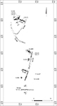
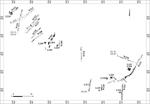
The area (c. 30 dunams; Figs. 2, 3) extended along a valley in which grumic soil accumulated. Five walls, three stone-clearance piles, a segment of an agricultural road, a path and three cupmarks were uncovered.
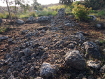
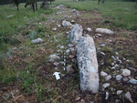
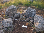
Walls (W100, W104, W105, W108, W110). Five walls were uncovered with different building styles and orientations, mostly defying attempts to determine whether they served as retaining walls to support cultivation terraces, or as partition or boundary walls between field-plots. Walls 100 and 108 are curved walls and not much soil accumulated around them, and it therefore seems that they were partition rather than retaining walls. In addition, a large upstanding stone (Fig. 4), that may have served to mark the boundary of a plot, was uncovered at the northern end of W100.
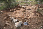
Wall 104 was built on an east–west axis and comprised two rows of large and medium-sized hewn stones and various-sized field stones. A probe dug through the wall exposed its foundation set on a natural rock-step and constructed of medium-sized roughly hewn stones bound by soil. Accumulated alluvial soil (depth c. 0.75 m) uncovered next to the wall permits defining it as a retaining wall of a cultivation terrace, this building technique known from similar walls. The stones of W110 were set on the ground surface, and it therefore seems to have been a partition wall. Wall 105, whose southern face was covered with accumulated soil indicating its function as the retaining wall of a cultivation terrace, abuts W110 and was poorly preserved. No items that could date the construction of the walls were found.
Stone-Clearance Heaps (L106: diam c. 4 m, height c. 0.33 m; L109: diam. 6.2 m, height c. 0.45; L111: diam. c. 6.3 m, height c. 0.48 m). Three roundish stone-clearance piles of various-sized fieldstones, delineated by a wall built of a single row of roughly hewn stones and extant for a single course, were found.
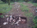
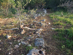
Agricultural Road (L124; Fig. 5). A segment of a curving road (width c. 5 m) was found. The road is bounded by two walls, and between them a fill of earth and small fieldstones (thickness c. 0.5 m) that was probably meant to level the bedrock. It seems that the road was used for access between the agricultural plots.
Path (W103; width c. 3 m). The path comprises scattered fieldstones of various sizes. The eastern end of the path abuts the upright stone integrated in W100, and its western end leads to the agricultural road. This path was apparently also used for accessing the agricultural plots.
Cupmarks (L126–128; diam. c. 0.4 m, depth c. 0.2 m). Three hewn cupmarks with a flat bottom were found.
Area B
This area (c. 67 dunams; Fig. 6) extends west of the Nahshonim Quarry, on a spur sloping down moderately towards Naḥal Shilo in the north and towards one of its tributaries in the east. Walls, stone-clearance heaps, a hewn installation, a path and meagre remains of a field tower were found.
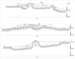
Walls. In the western part of the area, eight terrace-retaining walls (W200, W202, W208, W210–W213, W222) and a single partition wall (W221) were found on a moderate slope descending to the west. The retaining walls were oriented northeast–southwest, apart from W200 that was oriented north–south. All the retaining walls were dry-built of various-sized hewn stones. Probes dug through Walls 212 and 213 (Fig. 7) showed that they were built of two c. 1-m apart parallel walls, with a fill of various-sized fieldstones between them. Accumulated earth (max. depth 0.5 m) was found near the walls in both probes. Partition Wall 221 consisted of a single row of fieldstones on a north–south axis, and two upright stones, probably boundary-stones, were found at its southern end (Fig. 8).
Three cultivation-terrace retaining walls (W228, W231, W254) and two partition walls (W216, W220) were found in the eastern part of the area. Since this is a relatively flat area, the support walls were variously oriented, forming a sort of podium. A probe cut in W228 showed that the wall (width c. 2 m) was founded on the bedrock, and comprised a few rows of hewn stones lain on the slope. The maximum depth of the soil in the southern upper part of the cultivation terrace was 0.7 m, and the earth accumulated in the lower part of the terrace, on the northern-facing slope, was 0.1–0.3 m deep. A pOSL analysis indicated that the wall was probably built into an existing layer of earth, and the earth lower down on the terrace accumulated when the terrace was cultivated or after it was abandoned. Another probe, adjacent to W231, exposed a thick accumulation of earth (depth 0.8 m) east of the wall. The two partition walls were built of a single row of stones on a north–south axis.
Stone-Clearance Heaps. Nine stone-clearance piles were found: three rounded (L201, L205, L214), three rectangular (L203, L204, L225) and three irregularly shaped (L218, L224, L233). The heaps were founded on the bedrock, and contained small fieldstones, some heaps delineated by walls (L225, L233).
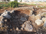
Rock-hewn Installation. An installation hewn into the bedrock (L250; Figs. 9, 10), comprising a square, plastered collecting vat (L241; 0.9 × 1.0 m, depth 0.9 m; plaster thickness 7 mm), a rectangular collecting vat (L249; 1 × 1 m, depth 0.77 m) and two drainage channels (L248, L251), was uncovered below stone-clearance Pile 233. The eastern side of Vat 249 was not extant, probably due to the subsequent quarrying of building stones. It seems that Channel 251 led northwest on the bedrock to Vat 241. Channel 248 led from the bedrock to Vat 249, the southern part of the channel making use of a natural fissure in the bedrock. Channel 248 was cancelled by the construction of W243, whose relation to the installation is not clear. A rectangular settling sump (L252; 0.25 × 0.40 m) was found next to the eastern corner of Vat 241, but no channels connecting the sump to the vats were found. A wall (W242) built of a single row of roughly hewn stones was uncovered between the two vats. The installation may have functioned as a winepress, in its early phase associated with Vat 249, and once this vat fell out of use, Vat 241 was hewn. It is possible that W242 was built in the later phase to separate the new vat from the abandoned older one.
Path (L217; exposure length c. 35 m, width c. 2 m; Fig. 11). The path consists of a wall built of a single row of hewn stones on a north–south axis, bordering a leveled layer of small fieldstones on the east; no border wall was found on the western side of the path. It seems that the path allowed passage between agricultural plots.
Field Tower (L219; diam. 1.7 m; Fig. 12). Meagre remains of a building were found, including three roughly hewn stones lying on their side to form a curving wall, possibly a field tower.
The excavation uncovered the remains of agricultural systems that are probably related to two main occupation phases exposed nearby: in the earlier period, farmhouses dating to the Persian and Hellenistic periods, and in the later period, remains of the Byzantine-period settlement uncovered at Ḥorbat Zikhrin. The extent of the agricultural activity in the Persian and Hellenistic periods is difficult to estimate, some studies suggesting that before the Byzantine period, areas close to the farmhouse were cultivated and there was no extensive use of cultivation terraces (Shadman 2016:198). Remains of agricultural systems encompassing extensive areas are usually attributed to the Byzantine period, when agricultural cultivation on slopes employing cultivation terraces reached its zenith in several regions of Israel (Bar 2008:113; Haiman 2012). It seems that most of the agricultural-systems remains found in the excavation should be attributed to the settlement at Ḥorbat Zikhrin, which reached its peak in the mid-Byzantine period. Agricultural plots were marked with boundary stones throughout the Byzantine period to mark settlement boundaries or for tax-collection purposes (Shadman 2016:168), the upright stones discovered in the excavation probably being such boundary stones. Some of the cultivation terrace walls uncovered in the excavation were built on level ground, and the accumulated soil was suitable for growing cereals and vines (Shadman 2016:247–248). No oil- or wine-production installations were found in the excavation area, apart from one hewn installation that may have been a winepress. However, the Byzantine-period industrial area uncovered at Ḥorbat Zikhrin contained numerous winepresses, as well as oil presses, possibly indicating the existence of extensive agricultural areas where olive trees and vines were cultivated for oil and wine production.
References
Amit D. and Zilberbod I. 1996. Mazor Survey. HA 106:99–100 (Hebrew).
Amit D. and Zilberbod I. 2001. Mazor (El‘ad), 1998–2001. HA–ESI 113:45*–46*.
Bar D. 2008. ‘Fill the Earth’: Settlement in Palestine during the Late Roman and Byzantine Period 135—640 CE. Jerusalem (Hebrew).
Fischer M. 1989. An Early Byzantine settlement at Kh. Zikrin (Israel). École Française de Rome 123:1787–1807.
Haiman M. 2012. Dating the Agricultural Terraces in the Southern Levantine Deserts—The Spatial-Contextual Argument. Journal of Arid Environments 86:43–49. https://doi.org/10.1016/j.jaridenv.2012.01.003
Kochavi M. and Beit-Arieh I. 2013. Rosh Ha-‘Ayin Map (78) (Archaeological Survey of Israel). Jerusalem.
Shadman A. 2016. The Settlement Pattern of the Rural Landscape between Nahal Rabbah and Nahal Shiloh during the Hellenistic, Roman and Byzantine Periods. PhD. diss. Bar Ilan University. Ramat Gan (Hebrew; English summary).
Taxel I. 2013. Identifying Social Hierarchy through House Planning in the Villages of Late Antique Palestine: The case of Ḥorvat Zikhrin. Antiquité Tardive 21:149–166. https://doi.org/10.1484/J.AT.5.101409
Keywords
Ancient agricultural systems, Ḥorbat Zikhrin, Byzantine period
Publication Date
26/05/2026
Report Type
Final Report