Ḥorbat Ḥuqoq (B-491/2020)
Permit/License Number
B-491/2020
Excavation Report
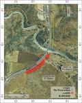
In October 2020, a salvage excavation was carried out at the northwestern edge of Ḥorbat Ḥuqoq, along the eastern side of Road 65 (License No. B-491/2020; map ref. 244933–5174/754598–8080; Fig. 1), prior to laying a gas pipe between the Golani and Qadarim Junctions. The excavation, on behalf of the Bar-Ilan University Archaeological Institute and funded by the Merimon Natural Gas North Ltd., was directed by S. Albaz, D. Cassuto and N. Bar-David (area supervision, field photography, aerial photography, photogrammetry, plans and models), with the assistance of A. Feldstein (administration), M. Iron (surveying) and A. Maeir (scientific guidance).
Ḥorbat Ḥuqoq is situated on the eastern slopes of the Lower Galilee, the rock types in the region including hard limestone strata of the Timrat Formation, and a basalt layer of the Cover Basalt Formation. Previous surveys and excavations along the western margins of Ḥorbat Ḥuqoq identified remains from the Early and Middle Bronze Ages, the Iron Age and the Hellenistic period, until modern times (Dalali-Amos 2014, and see further references therein). Remains exposed of the settlements on the hill itself included predominantly a Late Roman-period synagogue, a Mamluk-period public building—probably a synagogue, and the remains of the Late Ottoman Arab village of Yakuk (Magness et al. 2020; Tsur 2025, and see further references there). Agricultural terraces from the Roman and Byzantine periods were uncovered in a recent excavation north of the area (Fig. 1: B-494/2020).
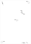
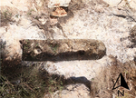
Four separate excavation squares (HS001, HS017, HS023, HS031; Fig. 2) were opened in the present excavation, within the area of the previous excavation conducted by E. Dalali-Amos (Dalali-Amos 2014: Area B [Fig. 1: A-6359]). Dalali-Amos uncovered Roman- and Byzantine-period pottery, a quarry and a hewn rectangular cist tomb (Dalali-Amos 2014: Site H, Fig. 22) adjacent to Square HS023; the tomb was measured in the present excavation (HS024; 0.5 × 1.9 m, depth c. 0.2 m; Fig. 3). Three earth layers (Layer 3–1) containing meager finds were uncovered in the present excavation squares. No other finds were uncovered in the mechanical clearance undertaken in the areas between the excavation squares, along the length of the pipeline and down to bedrock (depth c. 2 m).
Layer 3. A layer of sterile dark brown soil was uncovered on the bedrock, extending over the slope, ranging from c. 0.25 m deep in the northeast, to c. 1.3 m in the southwest.
Layer 2. A layer (depth c. 0.3 m) of lighter colored earth was intentional fill laid during the paving of Road 65, adjacent to the excavation. The few pottery fragments found in this layer included worn undatable body sherds.
Layer 1. A thin surface layer of dark brown earth and small stones (depth c. 0.1 m).
The meager finds in the excavation were not datable. The previous and the present excavations have demonstrated that the Roman and Byzantine-period inhabitants of Ḥorbat Ḥuqoq used the area west and northwest of the settled hill site to quarry building materials, for burials and for agricultural cultivation.
References
Dalali-Amos E. 2014. Horbat Huqoq. HA–ESI 126.
https://doi.org/10.69704/jhaesi.116.2004.12661
Magness J., Kisilevitz S., Grey M., Mizzi D., Burney J., Britt K. and Boustan R. 2020. Huqoq—2019. HA–ESI 132. https://doi.org/10.69704/jhaesi.116.2004.25880
Tsur Y. 2025. Horbat Huqoq. HA–ESI 137. https://doi.org/10.69704/jhaesi.116.2004.27730
Keywords
Hukok, Lower Galilee, Highway 65, Roman period, Byzantine period, Cultivation terraces, Stone quarry, Rock-cut burial
Publication Date
02/07/2026
Report Type
Final Report