Naḥal ‘Aṭarot (A-9154, A-9243)
Permit/License Number
A-9154, A-9243
Excavation Report
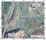
In November 2021 and March–April 2022, salvage and trial excavations were conducted on a hillslope descending towards Naḥal ‘Aṭarot, north of the Ramat Shlomo neighborhood in Jerusalem (Permit Nos. A-9154, A-9243; map ref. 220575–939/636047–462; Fig. 1), prior to extending the neighborhood. The excavation, on behalf of the Israel Antiquities Authority, was directed by D. Ben-Ayoun (2021 and 2022 seasons) and D. Gellman (2022 season), with the assistance of N. Nehama (administration), K. Arbiv (preliminary survey), A. Wiegmann (digital recording and photography), O. Zakaim (plan and location map), N. Ben-Melech (Tel Aviv University OSL analyses; the results will be published in the researcher’s Ph.D. diss.), T. Gonen (pottery restoration), D. Gazit (studio photography), I. Lidsky-Reznikov (pottery scanning), Y. Weingarten (ground stone tools; appendix) and IAA workers.
Twelve excavation areas (A–K) were opened on the hillslope, uncovering two buildings dated to Iron Age II (seventh–sixth centuries CE; Areas A and C), another building, documented but not excavated, probably also dating to Iron Age II (G), and five stone-clearance heaps (B, D, E, F, H), three field walls (I, K) and a natural cave (J).
Previous excavations in Ramot Forest, southwest of the excavation, uncovered remains of buildings, fortification wall and an Iron Age II tower, as well as a lime kiln, terrace walls, remains of an ancient road and stone-clearance heaps (Davidovich et al. 2006; Mizrahi, Katsnelson and Ariel 2016; Mizrahi and Forestani 2016; Gellman and Mizrahi 2019; Mizrahi et al. 2018). About 400 m east of the excavation, building remains, a burial cave, hewn cisterns and a winepress were documented close to the bend in Road 21 (Kloner 2001: Site 78). About 400 m north of the excavation, two hewn cisterns, probably from the Byzantine period, were documented in the southern part of Bet Ḥanina (Kloner 2001: Site 69). About 700 m south of the excavation, remains of a Late Roman- and Byzantine-period rural villa were documented at Khirbat er-Ras, located between Ha-Rav Arieh Goldknopf Street and Rabi Shlomo Zalman Druk Street in the Ramat Shlomo neighborhood (Onn et al. 2016).
Building Remains
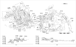
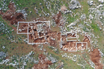
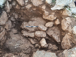
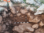
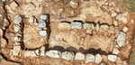
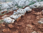
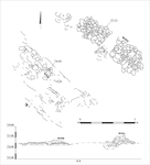
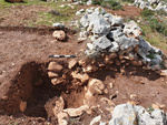
Area A (Fig. 2; 3D model). Remains of a building were uncovered in Area A, and a closed compound was found immediately to the north (Fig. 3), both dated to the seventh–sixth centuries BCE. The building (c. 6.2 × 7.5 m; 3D model) was divided into three parallel rectangular rooms (width of each room c. 2.5 m), whose single-row walls were built of partly dressed limestones. The southern part of the building’s western wall (W110) was not extant, either due to the high bedrock here, or as this was the location of the entrance. A crushed and packed limestone floor was found in the eastern part (L132) of the southern room, and a levelled bedrock floor in its western part (L146), with a deep earth accumulation layer (L145) between them. Earth accumulations (L137, L140) were found above Floor 146. In the southeastern part of the building, a short partition wall (W131) delineated a small space in the eastern part of the southern room. In the central room, an installation, built of small and medium-sized fieldstones arranged in a semi-circle (L139; Fig. 4), was found resting on the bedrock floor and abutting two of the building’s walls (W109, W112). Large heaps of collapsed stones (L154) that piled up after the building fell out of use lay inside and around the building, particularly to its north. A few narrow, long stones (Fig. 5) that originally served as columns supporting the roof, were found in these stone heaps. A small area of levelled bedrock floor (L144), overlain by an earth accumulation layer containing many pottery sherds (L135), was exposed east of the central room. Wall 109 extended to the east beyond the building, possibly indicating that the building extended further east beyond the excavation borders, or that the wall delineated an open courtyard on the north. The earth accumulation above the wall (L134) contained pottery sherds.
The compound north of the building (8.5 × 15.0 m) was oriented north–south. Its southern, western and eastern walls (W100–W102) were built of large to very large fieldstones set in deep depressions in the bedrock. The curved northern wall (W129), built of large and medium-sized fieldstones, was probably adapted to the hillslope. The northern wall does not abut the eastern wall that remained open on its northeastern side. A wall (W141/W151) inside the compound divides it into two. The walls were constructed differently from the southern building, with gaps between the stones, suggesting that it may have functioned as a livestock pen.
The many Iron II pottery sherds (ninth–sixth centuries BCE) mostly included table wares with some storage wares. Most of the pottery came from the southern building and from the collapsed stones (L154) between the building and the courtyard, a few sherds coming from the earth fills next to the northern compound walls (e.g., L107 next to W101).
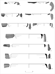
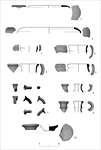
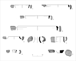
The pottery sherds included 57 bowls, most small (max. diam. 20 cm; Fig. 6:1–4) with a few larger ones (Fig. 6:5), 13 kraters, most large (min. diam. 40 cm; Fig. 6:8–10) and two different smaller ones (Fig. 6:6, 7), five cooking pot handles (not illustrated), three holemouth jars (Fig. 7:1, 2), two cooking jugs with pronounced ridged necks (Fig. 7:3, 4), six jugs (Fig. 7:5), nine jars (Fig. 7:6), three juglets (Fig. 7:7, 8), a laginos (Fig. 7:9) and a lamp (Fig. 7:10). Most vessels are common types in the ninth–sixth centuries BCE, the cooking jug and some small bowls only characteristic in the seventh–sixth centuries BCE.
A few stone vessels were also found in the building, including a Chalcolithic-period bowl fragment (?), agricultural-processing and grinding vessels, hammerstones and a weight (see ground stone tools appendix: Fig. 1:1–8). The absence of animal bones in the building may be attributed to poor preservation conditions.
Although no walls connected the southern building to the northern compound were found, their proximity and similar dating support the possibility that they were associated and contemporary.
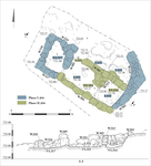
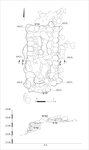
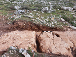
Area C (Figs. 8, 9; 3D model). Remains of a small building and a hewn installation dated to the seventh–sixth centuries BCE were uncovered, with two phases (I, II). The building (c. 2.4 × 3.2 m), attributed to Phase I, had walls built of large and medium-sized fieldstones (W305, W310, W324, W327), the entrance into the building set in W305, and the floor of levelled bedrock (L317). Next to and east of the building, a hewn installation divided into two parts was uncovered, a western part (L331; 2.9 × 3.2 m) and an eastern part (L332; 2 × 4 m), each with a levelled bedrock surface delineated by hewn rock walls; in the eastern part there was a deep pit. The rock-hewn walls were higher in the eastern part (max. height 0.9 m) than in the western part (max. height 0.4 m), as the eastern part of the installation was higher up the slope. An earth accumulation layer (L320) overlay the installation’s rock surfaces. Adjacent and east of the installation’s eastern wall, a fieldstone wall (W303, W315), extant for three courses, seems to have been built to prevent earth and stones from the slope from falling into the installation.
In Phase II, new walls (W302, W304, W313), extending the Phase I building to the east (c. 3.2 × 7.5 m), were built over the installation in the area between the Phase I building and W303; the entrance into the Phase II building was set in W302. Wall 313, an internal wall dividing the new space into two, was built on the rock between the two parts of the hewn installation, and an entrance (c. 0.9 m width) connecting the two rooms was set in it. In the western room, a small segment of a plaster floor (L322; 0.45 × 0.50 m) was uncovered, although it is not clear if it belonged to the Phase I installation or the Phase II building.
Earth and collapsed stones found in the building (L311 eastern side, L312 western side) probably collapsed from the walls after the building fell out of use. Pottery sherds dating to seventh–sixth centuries BCE were found in the earth layer in and around the building (L319, L326 north of W302). The Area C pottery sherds (far less than in Area A) includes 18 bowls, most small bowls (Fig. 10:1), four larger bowls (Fig. 10:2, 3, the former retaining wheel-burnishing), 10 large kraters (Fig. 10:4), three cooking pot handles (not illustrated), one jar (Fig. 10:5), five jugs (Fig. 10:6, 7, the former with incised decoration on the neck), a juglet (Fig. 10:8) and a lamp (Fig. 10:9). A few, out-of-context body sherds were identified by their ware as dating to the Late Chalcolithic Period. In addition, a single stone striking tool was found (see ground stone tools appendix: Fig. 1:9).
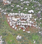
Area G (Figs. 11, 12; 3D model). A building was documented but not excavated as it lay outside the development area. The walls (W700–W703) were built of large fieldstones and preserved for one to two courses. The shape of the building, the size of the walls, and the adjacent finds suggest that this building probably also dates to Iron Age II, but this cannot be ascertained as the building was not excavated.
Stone-Clearance Heaps
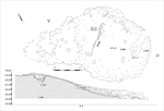
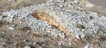
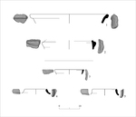
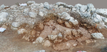
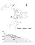
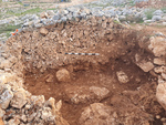
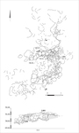
A large stone-clearance heap (L200; 14.8 × 26.5 m, height 2.1 m; Figs. 13, 14; 3D model) was uncovered in Area B, and a low supporting wall (W202) was found in the middle. Late Chalcolithic sherds retrieved amongst the stones included a bowl (Fig. 15:1) and a jar ledge handle (Fig. 15:2), and a few flint flakes were also found.
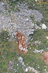
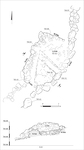
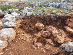
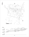
In Area D, a stone-clearance heap without a supporting wall was found (L402; 3.4 × 5.5 m, height 0.5 m; Figs 16, 17; 3D model).
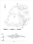
In Area E, a stone-clearance heap (L600; 10.0 × 16.3 m, height 1.3 m; Figs. 18, 19; 3D model) was uncovered, containing remains of a low supporting wall (W601). An Iron Age II jar sherd (Fig. 15:5) was found in the stone heap.
In Area F, a stone-clearance heap (L510; 4.5 × 6.0 m, height 1.5 m; Figs. 20, 21; 3D model) was bound by four walls (W503–W506). The eastern wall (W504) was a supporting wall of an ancient terrace that extended north and south beyond the heap. An Iron Age II bowl (Fig. 15:3) and a jar (Fig. 15:4) were found amongst the stones.
The stone-clearance heap in Area H was smaller than the others (L801; 3.8 × 4.5 m, height 1.2 m; Figs 22, 23; 3D model), and included remains of a supporting wall (W800).
Field Walls
In Area I, a field wall (W900; length 5.5 m, width 0.8 m, preserved height 0.75 m; Figs. 24, 25; 3D model) built of large and medium-sized fieldstones, was extant for one course. The context of the wall was unclear.
In Area K, two parallel field walls found about 5 m apart (W930, W931; length of each wall c. 10 m; Fig. 26; 3D model) were probably division walls between agricultural plots. Wall 930 (width 4 m, height 0.6 m; Fig. 27) was built on bedrock of one to two small fieldstone courses. Wall 931 (width 2 m, height 1.5 m; Fig. 28) was built of large and medium-sized fieldstones on the bedrock, and was extant for 10–15 courses.
Natural Cave
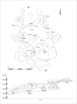
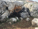
A natural cave (L911; 1.0 × 1.4 × 2.0 m; Figs. 29, 30; 3D model) with an entrance on the north, was found in Area J. At the front of the cave, north of its entrance, an area (c. 4.5 × 7.5 m), bounded on both sides by natural rock projections (L918, L919), was found. Three walls (W912–W914; W912 was not drawn), built of various-sized fieldstones on the bedrock, crossed the cave. A thin layer of earth, containing a few washed-in, undatable pottery sherds, and a few raw flint fragments, was uncovered inside the cave.
Conclusion
The Iron Age II structures uncovered in the excavation were part of a few rural buildings located on the hillslopes along Naḥal ‘Aṭarot. The many stone-clearance heaps, some small, join dozens of other stone-clearance heaps scattered over the hill. The heaps, together with the field walls, terrace walls and fences, were the result of preparing the area for cultivation in Iron Age II or other periods. In addition, the limited Chalcolithic-period pottery sherds found in a few spots may point to the presence of a site here from this period that has not yet been identified.
References
Davidovich U., Farhi Y., Kol-Ya‘akov S., Har-Peled M, Weinblatt-Krauz D. and Alon Y. 2006. Salvage Excavations at Ramot Forest and Ramat Bet-Hakerem: New Data Regarding Jerusalem’s Periphery during the First and Second Temple Periods. In E. Baruch, Z. Greenhut and A. Faust eds. New Studies on Jerusalem 11. Ramat Gan. Pp. 35–111 (Hebrew).
Gellman D. and Mizrahi S. 2019. Jerusalem, Ramot Allon HA–ESI 131. https://doi.org/10.69704/jhaesi.116.2004.25659
Kloner A. 2001. Survey of Jerusalem: The Northeast Sector (Archaeological Survey of Israel). Jerusalem.
Mizrahi S. and Forestani R. 2016. Jerusalem, Ramot Allon. HA–ESI 128. https://doi.org/10.69704/jhaesi.116.2004.24942
Mizrahi S., Freud L., Gellman D. and Gadot Y. 2018. What Kind of Village is This? Structures and Agricultural Activity in Northwestern Jerusalem in the Seventh Century BCE. In J. Uziel, Y. Gadot, O. Zelinger, O. Peleg–Barkat and O. Gutfeld eds. New Studies in the Archaeology of Jerusalem and its Region 12. Jerusalem. Pp. 191–213 (Hebrew).
Mizrahi S., Katsnelson N. and Ariel D.T. 2016. Jerusalem, Ramot Allon. HA–ESI 128. https://doi.org/10.69704/jhaesi.116.2004.25130
Onn A., Weksler-Bdolach S., Seligman J. and Rapuano Y. 2016. Two Interpretations of the Roman-Byzantine Peristyle House on the Shuʼafat Ridge (Ramat Shelomo), North of Jerusalem. In J. Patrich, O. Peleg-Barkat and E. Ben-Yosef eds. Arise, Walk Through the Land. Studies in the Archaeology and History of the Land of Israel, in Memory of Yizhar Hirschfeld on the Tenth Anniversary of his Demise. Pp. 121*–136*. Jerusalem.
Keywords
Iron Age II, buildings, stone-clearance heaps, field walls, natural cave, land preparation for agricultural activity, chalcolithic-period pottery
Publication Date
02/07/2026
Report Type
Final Report