Ḥorbat Menorim (A-9406, A-9461, A-9686)
Permit/License Number
A-9406, A-9461, A-9686
Excavation Report
During 2022–2023, a trial excavation, and subsequently a salvage excavation, were conducted at Ḥorbat Menorim, south of Tiberias (Permit Nos. A-9406, A-9461, A-9686; map ref. 251070–290/740036–220), prior to the construction of water reservoir. The excavation, on behalf of the Israel Antiquities Authority and funded by Mekorot Water Company, was directed by N. Silverberg, with the assistance of Y. Yaakobi and Y. Zilpa (administration), B. Tzin (probes), A. Najar (area supervision, trial excavation), M. Bekker-Shamir and A. Mokary (area supervision, salvage excavation), M. Kahan and Y. Shmidov (surveying and drafting), E. Delerzon (plans), A. Kleiner (photogrammetry), A. Peretz (field photography), A. Elghani Ibrahim and E. Aladjem (drone photography), D. Ben-Ami (consulting and scientific guidance), R. Beeri (scientific guidance), A. Shapiro (location map) and a group of tour guides and workers from Kafr Manda, Deir Hanna, Kabul, Bir el-Maksur and the Jenin area.
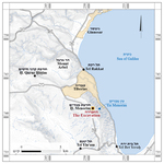
Ḥorbat Menorim (el-Manara) is located on top of a spur of the Poriya Plateau in Eastern Lower Galilee (Fig. 1). The c. 30-dunam site extends over basalt outcrops and overlooks views the fertile fields of the adjacent Yavne’el valley. In the 1980s and 1990s, the site was surveyed by Z. Gal and Y. Stepansky (Gal 1990:54; Stepansky 2016: Site 145). Two salvage excavations were previously conducted at the site, one uncovering three cist tombs dating to the beginning of Iron Age II (Braun 2001), and the other exposing remains mainly from Early Bronze IB and Iron Age IIA (Covello-Paran 2010).
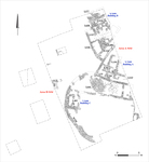
Two areas (A, B; Fig. 2) were opened in the present excavation, exposing the remains of three buildings (A–C) and a street dating from Iron Age IIA, and remains of buildings from the late Ottoman period and the transition to the British Mandate; the Iron Age II buildings will be preliminarily described here, while the late buildings will be published in the final report. Pottery sherds dating to Early Bronze IB, Intermediate Bronze Age, Middle Bronze II, and to the Roman and medieval periods, were found in the accumulations and habitation layers throughout the excavation areas.
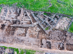
Area A (Fig. 3). Two large buildings with several rooms (Buildings A and B) were uncovered, founded on bedrock and separated by a street (L123). Architectural changes, including raised floors and cancelled installations and walls were identified, and it seems that both buildings had two building phases, early and late.
Building A comprised five rooms (L53, L59, L113, L126, L130). In the later phase, the floor levels were raised, and installations and partition walls were added. In the early phase, Building B comprised seven rectangular, elongated rooms (L518, L527, L576, L577, L608, L624, L638), and flat stone-paved floors, some integrating circular, fairly small installations. In the later phase, the floors were raised and made of packed-earth, and installations and a partition wall were added. In both phases, the two buildings were separated by a packed-earth street (L123) laid over the bedrock.
Area B. A square building (Building C), with a courtyard (L641) to the north, was exposed. The eastern part of the building was damaged by modern communication and electricity infrastructures; its extension to the east may have been dismantled during the construction of a modern gravel road. The western wall of the building was integrated in a rounded wall (W310; width 0.90–0.95 m, length c. 30 m), which was built of large and medium-sized basalt fieldstones and delineated the building on the west. Finds on the building floor (L405) dated it to Iron Age IIA. Although present-day infrastructure works cut W310, a no-longer extant segment of the wall apparently originally abutted Building A, whilst its southern end continued outside the excavation area. A segment of W310 was dismantled at the point where the western wall of the building abutted it, and pottery sherds in the wall foundation dating its construction to Iron IIA.
A multi-period site was uncovered at Ḥorbat Menorim, its rich pottery assemblage attesting to a presence at the site during the Early, Intermediate, and Middle Bronze Ages, the Iron Age, and the Roman, medieval and Ottoman periods. The internal division of Buildings A and B, and the finds within them, suggest that both buildings probably served for household activities, storage, and domestic processing of agricultural products.
References
Braun E. 2001. Iron Age II Burials and Archaeological Investigations at Ḥorbat Menorim (el-Manara), Lower Galilee. ‘Atiqot 42:171–182. https://publications.iaa.org.il/atiqot/vol42/iss1/14
Covello-Paran K. 2010. Settlement Remains from the Bronze and Iron Ages at Ḥorbat Menorim (el-Manara), Lower Galilee. ‘Atiqot 63:1–14. https://doi.org/10.70967/2948-040X.1275
Gal Z. 1990. Lower Galilee: Historical Geography in the Biblical Period. Tel Aviv (Hebrew).
Stepansky Y. Tiberias Map—39 (The Archaeological Survey of Israel). Jerusalem.
Keywords
Multi-period site, remains of a settlement from the Iron Age II, remains of a settlement from the Ottoman period, finds from the Early Bronze Age IB, Intermediate Bronze Age, Middle Bronze Age II, Roman, Middle Ages
Publication Date
02/07/2026
Report Type
Preliminary Report