Yafo, Shim‘on Ha-Ẓadiq Street (A-8302, A-8406)
Permit/License Number
A-8302, A-8406
Excavation Report
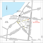
During July, August and November 2018 and March–April 2019, salvage excavations were conducted on Shim‘on Ha-Ẓadiq Street, Yafo (Permit Nos. A-8302, A-8406; map ref. 177152–431/662228–533; Fig. 1), prior to infrastructure work. The excavations, conducted on behalf of the Israel Antiquities Authority and financed by Ha-Mishlama Le-Yafo, were directed by Y. Arbel (field photography), with the assistance of L. Rauchberger (area supervision), Y. Amrani and E. Bachar (administration), R. Mishayev and M. Kahan (surveying and drafting), A. Dagot (GPS), A. Pulitzer, A. Acksman and V. Bosidan-Gadol (youth education), A. de Vincenz (pottery), R. Kool (numismatics), I. Ktalav (mollusks), A. Glick (historic weapons) and C. Amit and D. Gazit (studio photography). Assistance was also provided by D. Barkan and D. Abu-Salah from the IAA Tel Aviv District, workmen from northern Israel and youth groups and students from premilitary programs.
Shim‘on Ha-Ẓadiq Street is on the northern boundary of contemporary Yafo, between the Greek Market on the west, ‘Ole Ẓiyyon Street and the flea market on the south, a residential neighborhood on the east and Marzuq and ‘Azar Street on the north (Fig. 1). The residential neighborhood where Shim‘on Ha-Ẓadiq Street is located was built on agricultural lands during the British Mandate (the 1930s and 1940s; Kark 1990:70–72) as part of the rapid urban expansion of Yafo, which started towards the end of the Ottoman rule and reached its zenith during the British Mandate (Goren 2016:201–202). An aerial photograph from 1917 shows that Shim‘on Ha-Ẓadiq Street was preceded by an agricultural track between orchards, with the first buildings in its southeastern part (Yinon 2001:282). Expansion of the neighborhood is apparent in a 1929 map and a mid-1930s map show that the neighborhood is fully built (Goren 2016: Maps 1, 2). An aerial photograph from 1949 shows Shim‘on Ha-Ẓadiq Street as a fully urban wide street (Navon 2019:214). The street had large and opulent houses, some two or three stories high, with modern infrastructure, reflecting the affluent economic status of many of the neighborhood’s residents.
A previous excavation on Shim‘on Ha-Ẓadiq Street (Glick 2017 [Fig. 1: A-6247]) exposed building remains from the Hellenistic period, a public building with an apse from the Byzantine period, segments of walls from the Umayyad period and an installation from the end of the Ottoman period. Past excavations in the vicinity of the site were conducted in the flea market (Peilstöcker et al. 2006 [Fig. 1: A-3740]; Barkan and Bouchenino 2012 [Fig. 1: A-5455]), in the Ben Gamli’el compound (unpublished [Fig. 1: A-7071]), on Jerusalem Boulevard (Jakoel 2011 [Fig. 1: A-5456]) and on Ben Dosa Street (unpublished [Fig. 1: A-8709]). Remains uncovered in these excavations encompassed the Persian, Hellenistic, Roman, Byzantine, Crusader and Ottoman periods, as well as British Mandate foundations of buildings and infrastructure.
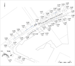
Forty-five squares (4 × 4 m, max. excavation depth c. 2.5 m; Fig. 2) were opened on Shim‘on Ha-Ẓadiq Street, and six more (max. excavation depth 1.5 m) were opened on Ben Azarya Street, a connecting road. Many of the squares were joined during the excavations. Three distinct strata were identified, containing finds from the Iron Age to the Ottoman period. The excavation remains include large installations, wall foundations, a lime pit, a canal and a cluster of cannon balls. The finds were dated to the end of the Ottoman period–beginning of the British Mandate. A cluster of kurkar stones, which may be the remnants of an earlier installation, was also found.
The excavation was conducted below an asphalt and packed lime layer, which was probably the bedding remains of the earlier street. No evidence of a soling road with a bedding made of packed stones, characteristic of the British Mandate, was found. Three strata, similar to ones found at many sites east of Tel Yafo, were exposed below the lime layer. The thick bottom stratum comprised of dark packed earth. It contained primarily fragments of Byzantine-period jars, as well as pottery, glass fragments and coins from the Iron Age and the Hellenistic, Roman–Byzantine, Early Islamic and Crusader periods. Of note is a bronze chain, probably used to hang oil lamps, which may be associated with the nearby previously discovered Byzantine-period building (Glick 2017). An accumulation of sand with few finds comprised the middle stratum (depth 0.2–0.6 m). The top stratum included packed earth with small stones (max. depth 0.4 m), and it sealed the agricultural road, which was dated to the Ottoman period. Fragments of local and imported pottery and glass, dating from the eighteenth to the first half of the twentieth centuries CE, were found in this material.
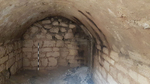
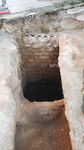
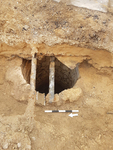
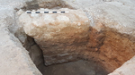
Two cesspits (L246, L279), a well (L212) and clay and metal pipes from the end of the nineteenth–beginning of the twentieth centuries CE were exposed in the excavation. Cesspit 246 (Fig. 3) located in the middle of the street, was preserved intact. The pit’s ceiling was vaulted and plastered, and its sides were built from dressed kurkar stones. A chute linked into a drained on its southeastern side. The opening of the cesspit was on its southwestern end, and it was cemented over when the cesspit went out of use during the British Mandate. Cesspit 279 (Fig. 4) was uncovered in the junction of Shim‘on Ha-Ẓadiq and Ben Azarya streets, and only its sides survived. The vaulted ceiling was destroyed when the street was paved. The finds from the two cesspits are meager, and they probably washed in after the cesspits went out of use. Cesspits with similar construction and capacity were found at several sites within the walls of Yafo (Arbel 2010) and along Razi’el Street outside the old city (Jakoel and Marcus 2017:52–58). Cesspits were common in Yafo throughout the Ottoman period. A new sewage system was installed in the 1890s underneath some of the streets in the city center (Kark 1990:204), but the suburbs relied on cesspits until the British Mandate (Goren 2016:104–105). These pits serviced the private homes of the affluent. Well 212 (Fig. 5), like other wells in the area, remained in use until the 1940s (Goren 2016:182, 198, 262–263, 336–337, 402). The glazed clay and metal water pipes discovered during the excavation were probably manufactured in England and were part of a sewage system that was installed gradually under the streets during the British Mandate.
The wall exposed in the excavation (W268; Fig. 6) was discovered next to Cesspit 279. It was set on a foundation arch and constructed of hewn stones bonded with mortar made from ḥamra. This technique was common in public and affluent private construction in Yafo during the nineteenth century CE, and it is known from many sites.
The lime pit and the canal were discovered in the eastern part of the excavation (not on the plan). The irregularly shaped lime pit probably served the builders of the street at the end of the Ottoman period or during the British Mandate, like the lime pits in the nearby Greek Market (Arbel 2016).
In the eastern part of the excavation, numerous cannon balls were found in earth accumulations. They dated to the nineteenth century CE. This concentration may indicate that prior to the paving of the street, the area was an outpost of the military force that laid siege to Yafo in the first half of the century. The historical events in which this outpost may have played a role are the struggles between rival Ottoman commanders in the years following Napoleon’s withdrawal and the Peasant's Uprising of 1834. During those events Yafo sustained several siege episodes (Schiller 2015:79–80).
A cluster of kurkar stones, which may have been part of a coarsely constructed installation from the Byzantine or Early Islamic period, was found in the eastern part of the excavation (not on the plan).
The absence of building remains on Shim‘on Ha-Ẓadiq Street indicates that the area was part of Yafo’s agricultural hinterland and lay outside the boundaries of the city of Yafo until the end of the Ottoman period and the British Mandate. During the Ottoman period this area was part of the agricultural lands of Yafo, and under the British Mandate a residential quarter was constructed there for the first time.
Excavations in this neighborhood significantly contribute to tracking the urban expansion of Yafo during the twentieth century CE to grounds previously outside the urban sphere. The remains reflect the technologies of construction and infrastructure of the period.
References
Arbel Y. 2010. Yafo, Ha-Ẕorfim Street. HA-ESI 122. https://doi.org/10.69704/jhaesi.116.2004.1474
Arbel Y. 2016. Yafo, the Greek Market. HA-ESI 128. https://doi.org/10.69704/jhaesi.116.2004.25112
Barkan D. and Bouchenino A. 2012. Yafo. HA-ESI 124. https://doi.org/10.69704/jhaesi.116.2004.2161
Glick A. 2017. Yafo, Shim‘on Ha-Ẕadiq Street. HA-ESI 129. https://doi.org/10.69704/jhaesi.116.2004.25314
Goren T. 2016. Rise and Fall: The Urban Development of Jaffa and its Place in Jewish–Arab Strife in Palestine 1917–1947. Jerusalem (Hebrew).
Jakoel E. 2011. Yafo, Jerusalem Boulevard (East). HA-ESI 123. https://doi.org/10.69704/jhaesi.116.2004.1652
Jakoel E. and Marcus J. 2017. The Northeastern Fringes of Yafo (Jaffa) in Light of the Excavations on Jerusalem Boulevard and Its Vicinity. ‘Atiqot 88:43*–70* (Hebrew; English summary, pp. 157–158). https://doi.org/10.70967/2948-040X.1799
Kark R. 1990. Jaffa, A City in Evolution 1799–1917. Jerusalem.
Navon V. 2019. The Boulevard: Jerusalem Boulevard Through the Eyes of the Photographers. Tel Aviv (Hebrew).
Peilstöcker M., Re’em A., Haddad E. and Gendelman P. 2006. Yafo, Flea Market Complex. HA-ESI 118. https://doi.org/10.69704/jhaesi.116.2004.431
Schiller E. 2015. The Early Modern Time in the History of the Land of Israel: The Egyptian Rule (1831–1840). Ariel 209:80–97 (Hebrew).
Yinon Y. 2001. Around the Clock Square. Jerusalem (Hebrew).
Keywords
Jaffa, Ottoman period, British Mandate, Cesspits, Urban infrastructure, Sewage system, Byzantine period, Cannonballs, Urban expansion
Publication Date
02/08/2026
Report Type
Preliminary Report