Meẓad Ẓafit (East) (A-9515)
Permit/License Number
A-9515
Excavation Report
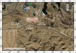
During January 2023, a salvage excavation was conducted c. 800 m east of Meẓad Ẓafit and west of ẒafitJunction (Permit No. A-9515; map ref. 218840–65/550310–35; Fig. 1), prior to laying a natural gas pipeline. The excavation, on behalf of the Israel Antiquities Authority and financed by the Israel Natural Gas Lines Company, was directed by T. Sapir (field photography), with the assistance of Y. Alamor (administration), E. Aladjem (surveying), I. Azoulay (drafting), A. Golani (scientific guidance), L. Davies (flint), G. Seriy and D. Eisenberg-Degen from the Southern Region and workmen from the Palestinian Authority.
Meẓad Ẓafit was discovered in past surveys, which recorded in the surrounding area buildings, cairns and mounds from prehistoric periods to the British Mandate (License Nos. S-695/2016, S-926/2019, S-1017/2020, S-1222/2022). Approximately 250 m southeast of the excavation, near Naḥal Ẓafit, a Timnian campsite (end of fifth–beginning of fourth millennia BCE) was discovered (Knabb et al. 2018 [Fig. 1: G-83/2018]), and in it were circular buildings and an installation. The present excavation was located in Spot No. 6 of the Development Survey S-1017/2020.
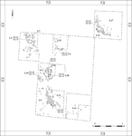
The excavation (Fig. 2) was located on a moderate slope of a low hill, and it uncovered meager remnants of three walls (W1, W2, W14) and four installations (L3, L4, L10, L28) that were visible on the surface prior to the excavation.
The walls and installations were built from medium-sized fieldstones and preserved to a height of one course. The paucity of collapse heaps and finds indicate short-term occupation. The outlines of Walls 1 and 14 (width 0.5 m) are rounded, and they open to northeast. Only a short segment of W2 survived. Installation 3 has a circular outline (diam. c. 2 m), and it is delineated by a single line of stones. Installation 4 is delineated by a wall constructed from a single line of stones. To its northeast, a few stones, which are probably a continuation of the installation (max. length of installation 5 m), were found. Installation 10 has a circular outline (diam. c. 0.9 m). Installation 28 is adjacent to W2 and has a square outline (c. 0.8 × 0.8 m).
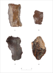
Sixty-six flint items were found in the excavation (Table 1). They were found between the stones of the walls and installations and on the surface (L5, L12). There is locally available raw material from the Mishash formation, which was subjected to a natural erosion process, and as a result crumbled and scattered on the surface. Most of the items are knapping debitage, predominantly flakes and primary flakes, and there are also a few core modifications, blades and bladelets. In addition, six tools were found (Table 2), including four retouched flakes (Fig. 3:1–3), one of them an end scraper (Fig. 3:4), a notch and a retouched blade truncated on the distal end. The raw material is of poor quality, and the tools are poorly preserved, so they could not be used to date the site.
Although the remains that were uncovered in the excavation are poorly preserved, their proximity to the camp site in Naḥal Ẓafit and the architectural similarities seem to indicate that the area was used as a temporary camping site
References
Knabb K., Rosen S., Hermon S., Vardi Y., Kolska-Horwitz L. and Goren Y. 2018. A Middle Timnian Nomadic Encampment on the Faynan–Beersheba Road: Excavations and Survey at Nahal Tsafit (Late 5th/Early 4th Millennia BCE). BASOR 380:27–60. https://doi.org/10.5615/bullamerschoorie.380.0027
Keywords
Meẓad Ẓafit, Naḥal Ẓafit, Negev, Timnian Culture, Nomadic Encampment, Stone Structures, Installations, Flint Industry, Prehistory
Publication Date
02/08/2026
Report Type
Final Report