Ḥorbat Marshan (A-8915, Z-34/2022)
Permit/License Number
A-8915, Z-34/2022
Excavation Report
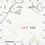
During December 2021 and December 2022, two excavation seasons were conducted at Ḥorbat Marshan, next to Naḥal Shiqma (Permit Nos. A-8915, Z-34/2022; map ref. 167726–55/605379–427; Fig. 1). The excavation, on behalf of the Israel Antiquities Authority, is a community project, with the participation of ninth grade students from Sha’ar Ha-Negev High School. The excavation was directed by O. Shmueli and S. Bloch-Lifshitz, with the assistance of Y. Alamor (administration), E. Aladjem, A. Montagu and I. Azoulay (surveying and drafting), A. Levy (aerial photography), A. Golani (scientific guidance), L. Kupershmidt (metal laboratory), D. Gazit (studio photography), A. Lester (metal bracelet), J. Auerbach, K. Sorkin and A. Fraiberg (digital laboratory), N. Wieler (geology), R. Dagan, H. Azrad, G. Zohar, A. Lehavi and H. Ettel (education), K. Sofer, D. Tovim, Y. Borodowicz, H. Shahar and A. Chen from the Israel Nature and Parks Authority, O. Libstein and Y. Dadiya from the Sha‘ar HaNegev Regional Council and R. Lax, T. Mizrahi, G. Klein-Duanis and A. Drori from the school. Assistance was also given by M. Ajami, O. Barzilai, S. Ganor, A. Rasiuk, V. Lifshitz and T. Kayesar from the IAA Southern Region.
Ḥorbat Marshan extends about 2 km southwest of Kibbutz Beror Ḥayyil and about 250 m south of Naḥal Shiqma (Fig. 1). The site was surveyed by the Palestine Exploration Fund (PEF) in the 1870s, and it was marked on the map as a small ruin (Kh. el-Marashan). A survey of Naḥal Shiqma in 1977 documented remains of a Byzantine settlement (c. 20 dunam) at the site, which included remains of structures and two cisterns as well as the ruins of a deserted Arab village (Lamdan et al. 1977:182). The site was also surveyed by the Archaeological Survey of Israel (Huster 2017: Site 138), and remains of an ancient settlement were identified below the ruins of an Arab village dating to the late Ottoman period and the beginning of the British Mandate. Finds from the Middle Bronze Age I and the Roman period to present day were collected.
Two excavation squares were opened on the western edges of Ḥorbat Marshan, and remains of a massive structure were uncovered, dated based on the ceramic finds to the Byzantine and Early Islamic periods (sixth–ninth centuries CE). A fragment of a clay pipe from the late Ottoman period and a fragment of a metal bracelet were also discovered.
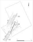
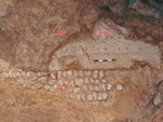
The structure. Part of a single-phase massive structure (Figs. 2, 3) was uncovered, including a segment of a mosaic floor (L103; c. 1.0 × 2.7 m) and two walls (W1, W2). The mosaic floor was laid on a bedding of white mortar and river pebbles, and it was made of small white, blue and red tesserae, laid at a density of 100 tesserae per sq decimeter. The mosaic is decorated with three blue and red parallel stripes that probably framed the mosaic. Red plant motifs, which may be ivy leaves, hang from the internal red band. The mosaic floor abuts Walls 1 and 2. Wall 1 (width 0.51 m, exposed length c. 1.5 m) survived to a height of three courses of hewn kurkar stones bonded with mortar. The external face of the wall was plastered in white. Of W2 (width 0.5 m, exposed length 1.8 m), only the foundation course, which was constructed of large river pebbles, survived. Above the mosaic floor, loess mixed with pottery sherds accumulated (L101), probably as debris once the structure went into disuse.
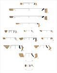
The pottery. The pottery finds found in L101 date to the end of the Byzantine–beginning of the Early Islamic period (Fig. 4:1–13), except for the tobacco pipe (Fig. 4:14), which dates to the end of the Ottoman period. Bowl 1 has a simple rim. Bowls of this type are common in the eighth–tenth centuries CE. Bowls 2 and 3 are shallow and have a simple rim folded inward; this style is common in southern Israel in the sixth–seventh centuries CE. The rim of Bowl 3 is decorated with thumb imprints. Bowl 4 is CRS Ware and has an in-turned rim; it is common from the sixth–first half of the eighth centuries CE. Cup 5 is FBW Ware and has a simple rim that leans slightly out and wavy incised decoration on the body. Cups of this type are common in the mid-sixth–beginning of eighth centuries CE. Jug 6 is made of buff clay, and it has a ridge on the neck and a simple rim that leans slightly out. Jugs of this type are common in in the second half of the eighth–tenth centuries CE. Cooking pots 7 and 8 have a hemispherical body and straight rim, with an S-profile, and are common in the eighth–tenth centuries. The cooking pots have short neck and triangular rim. Pots of this type are common in the fifth–seventh centuries CE. Jar 10 has an out-turned rim. Bag-shaped jar 11 has a thickened and out-turned rim. This type is common in the second half of the seventh–eighth centuries CE. Gaza jars 12 and 13 were common in the sixth–seventh centuries CE. Clay tobacco pipe 14 is dated to the end of the Ottoman period. The pipe is mold-made from brown well-fired levigated clay and has rouletted decoration. Its chamber has a concave base. Tobacco pipes of this type were common in the nineteenth century CE.
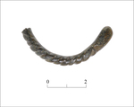
Metal Bracelet. A fragment of brass bracelet with twisted decoration (L101, Basket 25/2001; Fig. 5:1) was found in the fill over the mosaic floor. One end of the bracelet is straight, and the other is broken. It may date to the end of the Ottoman period.
Conclusion. The excavation exposed part of a public structure or an elaborate farmhouse paved with a colorful mosaic and built on the fringe of the Byzantine-period settlement. Analysis of the pottery indicates that the structure was used during the Byzantine and Early Islamic periods (sixth–nineth centuries CE). The tobacco pipe and fragment of a metal bracelet that were dated to the end of the Ottoman period indicate renewed occupation during this period. The site is marked in the PEF map as a ruin rather than a settlement, suggesting that the nearby village of el-Marashan was established at the end of the nineteenth–beginning of the twentieth century.
References
Huster Y. 2017. Map of Sderot - 96 (Archaeological Survey of Israel).
Lamdan M., Ziffer D., Huster Y. and Ronen A. 1977. A Prehistoric Archaeological Survey in Nahal Shiqma. Sha'ar Hanegev (Hebrew).
Palmer E.H. 1881. The Survey of Western Palestine: Arabic and English Name Lists. London.
Keywords
remains of a building, mosaic floor, public building, farmhouse, Byzantine period, Early Islamic period, clay pipe, Ottoman period, metal bracelet
Publication Date
02/08/2026
Report Type
Final Report