Jerusalem, Har Nof (A-9242)
Permit/License Number
A-9242
Excavation Report
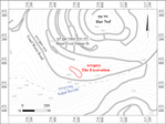
During March and April 2022, a trial excavation was conducted at the foot of Ha-Rav Shaul Even Danan Street on the southwestern fringe of the Har Nof neighborhood in Jerusalem (Permit No. A-9242; map ref. 2164–6/6318–9; Fig. 1), prior to constructing a school. The excavation, on behalf of the Israel Antiquities Authority and funded by the Moriah Jerusalem Development Corporation, was directed by M. Hagbi (field photography) and R. Cohen, with the assistance of D. Tanami (preliminary inspection), O. Chalaf (area supervision), N. Nehama (administration), S. Halevi and E. Marco (field photography, surveying and 3D model), O. Zakaim (plans), Y. Zelinger and A. Peretz (archeological guidance), I. Reznitsky (metal laboratory) and D. Gazit (studio photography). We wish to thank the excavation workmen for their hard work.
The excavation was conducted on a hill slope, along the northern bank of Naḥal Revida. A previous survey in the area identified mainly agricultural installations hewn into the bedrock (Kloner 2003: Sites 54, 64–67, 69, 71, 72), tombs (Kloner 2003: Sites 49, 51–53, 63, 74, 84–87, 90, 92, 96), agricultural terraces and watchtowers (Kloner 2003: Sites 77, 91). In a development survey that was conducted in the nearby Jerusalem Forest in 2001, 12 hewn winepresses, 12 hewn cisterns, 31 watchtowers, 12 hewn burial caves, two lime pits, stone quarries and at least four well-preserved agricultural terraces were surveyed (Weiss 2006). A three-story fortified building, probably a farmhouse, was found at Ḥorbat Tut, north of the excavation, and in its vicinity, a cave and four winepresses were also found. The building was dated to the Byzantine period and remained in use through the Crusader and Mamluk periods (Kloner 2003: Site 68; Gat 1982a; 1982b). In addition, c. 47 Middle Bronze Age shaft tombs were discovered c. 200 m north of the site (Greenhut and Re’em 2001; Kloner 2003: Site 78).
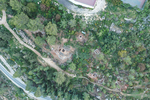
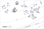
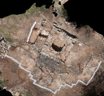
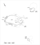
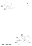
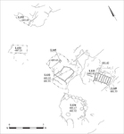
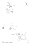
A building (L100), caves (L105, L128, L132, L133, L152, L153, L155), shaft tombs (L123, L150, L154), quarries (L110, L143, L144), a cistern (L111) and hewn installations (L120, L134) were found in the present excavation (c. 450 sq m; Figs. 2, 3).
Building 100
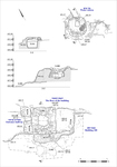
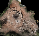
The building is square and constructed from soft limestone (Figs. 4, 5; 3D model). Three building phases were identified (1–3). In Phase 1, whose date is unclear, a building that probably served as a watchtower was built. In Phase 2, the walls were reinforced, and the building was used as a guard post. In Phase 3, the entry to the building was blocked, and it went out of use.
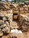
Phase 1 (ext. dimensions c. 4.7 × 5.1 m). During this phase, a building with wide walls (width c. 1 m) was built. Its external corners were built of elongated soft limestone ashlars, while its ovoid interior was constructed from stones in a range of sizes. The bedrock surface served as the building’s floor (L137). The original roof was a dome, which collapsed for an unknown reason. Quarrying marks were found in the vicinity of the building (L102); these were likely related to an ancient quarry over which the building was constructed. The entrance to the building (height c. 1 m, width c. 0.6 m) was set into the western wall (Fig. 6) and built of well-dressed limestones. The doorposts protruded into the structure’s interior, and it seems that the door opened inward. A socket for a bolt was visible in the left doorpost. No datable finds were discovered in the building. During this phase, the building likely functioned as a watchtower. Additional watchtowers were uncovered in a survey of the slopes of nearby Giv‘at Sha’ul (Kloner 2003: Sites 77, 91).
Phase 2. The southern and western walls of the building (W112, W114) were thickened by c. 1 m in this phase, while the eastern wall (W113) was thickened by c. 3.5 m. The reinforced walls were built of medium and large-sized fieldstones. An entrance corridor (L138) was built in W114, providing access to the building. A bullet of a Mauser rifle, a small glass medicine bottle and a ‘mess-tin’ that was used as a metal military eating utensil (not illustrated) were found in W114. These finds are probably associated with the Ottoman soldiers who were stationed here, reinforced the building walls and turned the building into a military outpost in preparation for the attack by the British army. This phase is dated to the end of the Ottoman period.
Phase 3. During the final phase of the building, the entrance was blocked with fieldstones. This blockage was incorporated into the reinforced W114 on the western side of the building, ending the building’s use.
Caves
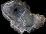
Cave 105 (Figs. 7, 8). A natural oval-shaped cave was uncovered; the cave’s ceiling had collapsed. Excavation was limited to its southern half and did not reach its base. Inside the cave, an accumulation of compacted marly material was found, resulting from the ceiling collapse. Along the cave’s western edge, several low stone walls (W124–W126, W129) were uncovered. Preserved to a height of a single course, they demarcated the cave’s interior and likely enclosed it during its initial period of use. In the southern part of the cave, remains of a quarry used to extract small stones (L107, see below) were found. This quarrying represents a later phase of activity that postdates the cave’s primary use, and it damaged the cave’s sides and ceiling.
Cave 128 (Fig. 9). A cave opening with a layer of packed-earth in front of it (L141) was exposed. A wall (length c. 0.9 m, width c. 0.3 m) built from fieldstones was uncovered across from the entrance and on the packed-earth layer. The cave entrance was not fully exposed, and the interior was not exposed at all.
Cave 132 (Fig. 10). A rectangular hewn cave (width c. 2 m) with half of its ceiling collapsed was uncovered down the slope. It was not fully excavated, and therefore its length cannot be ascertained, and the excavation did not reach its floor. The cave’s ceiling was vaulted, and the cave’s entrance was not found. However, judging by the direction of the slope, the entrance faced south. Inside the cave, in its upper part, there was a layer of soil with a considerable quantity of modern refuse. Below it, there was a layer of sterile soil. A square hewn area was found in the bedrock above the cave (L145). This cave and Cave 133 (see below) are close to each other and may be connected.
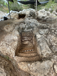
Cave 133 (Fig. 10). The cave was hewn into the bedrock and found at the foot of Cave 132 on the south. Seven hewn steps (L149; Fig. 11) descended from the surface to the cave’s entrance. The steps were hewn in a similar width (width c. 1 m), except for the lower step, which was narrower (width c. 0.75 m). Comparison with similar caves suggests that this may have been a burial cave or a miqveh.
Cave 152 (Fig. 10). The entrance to the cave is visible in the upper part of the slope and the excavation area. The excavation was conducted on the western face of the cave, which had a hewn entryway. Soil fill containing a large quantity of modern finds was excavated. A hewn vertical bedrock face was identified in the eastern part of the cave, probably representing one of the cave’s walls or another entrance.
Cave 153 (Fig. 10). The excavation (depth c. 0.5 m) was restricted to the front of the cave. An accumulation of soil containing a large quantity of modern finds was excavated.
Cave 155 (Figs. 7, 12). The cave was exposed on a bedrock terrace. The cave’s ceiling collapsed, and the cave’s size is unclear. The inside of the cave was not excavated because of safety concerns. The cave entrance faces southwest. In its southeastern wall, a hewn arch was uncovered, perhaps part of a tomb within the cave.
Shaft Tombs
Three hewn shaft tombs were found. These were probably associated with a cemetery that was previously discovered c. 250 m north of the present excavation (Greenhut and Re’em 2001), which contained c. 47 shaft tombs dating to the Middle Bronze Age. There may be more tombs in the excavation area, which will be uncovered in the future.
Tomb 123 (Figs. 9, 13). A circular vertical shaft (diam. c. 1 m, depth c. 2 m) was exposed. At the bottom of its eastern side, there was an arched entranceway leading to a burial niche. The niche was not excavated.
Tomb 150 (Fig. 7). A circular vertical shaft (diam. c. 1 m, depth c. 1.5 m) was uncovered. At the bottom of its eastern side, there was a partially excavated niche, which was presumably a burial chamber. No bones were found in the excavation of the tomb, so the tomb was seemingly robbed.
Tomb 154 (Fig. 14). Remains of a vertical shaft (estimated diam. c. 1 m, depth c. 1.5 m) were found cut into one of the hewn rock faces of Quarry 110 (see below). The quarrying activity likely cut through the shaft. No burial niche was found in the surviving side of the shaft, and it may have been damaged by quarrying activity. Therefore, it can be determined that the quarry postdates the tomb.
Quarries
Quarry 107. Remains of a quarry used for small stones were identified on the southern fringe of Cave 105 (Figs. 7, 8). The quarrying activity seems to have damaged the walls and ceiling of the cave, and therefore the quarry may postdate the cave.
Quarries 110, 143, 144. These three quarries (Fig. 14) are situated close together and were probably part of one extensive quarry that operated on the hill and damaged the installations and tombs that predated it. Quarrying channels that were identified on the bedrock of Quarry 110 reflect the production of quite large stones (0.7 × 1.0 m). In Quarry 143, excavations discovered quarrying marks for medium-sized blocks (0.4 × 0.4 to 0.5 ×0.6 m), which were probably used for local private construction. Quarry marks for medium-sized stone blocks were also identified in Quarry 144.
Cistern 111
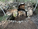
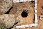
A water cistern was exposed (int. dimensions 1.6 × 1.6 m; Figs. 4, 15; 3D model). It was dug into the ground, partially cutting into a terrace, and it was lined with roughly hewn stones and fieldstones. The interior was coated with pinkish plaster. The ceiling was vaulted, and at the top there is a modern breach, which may have been formed deliberately to widen the original opening. Around the cistern’s exterior, a wall (W151) was built from small fieldstones, and it was probably used to support the sides of the cistern. Nowadays, the cistern serves as a miqveh for the residents of the neighborhood.
Installations
Installation 120 (Fig. 9). A rectangular pit (0.5 × 1.6 m, depth 0.6 m) that was hewn into leveled bedrock was uncovered; its function is unclear. Next to the installation, small square rock-cut niches (L121; 0.2 × 0.2 m depth 0.25 m) were found on the leveled bedrock.
Installation 134 (Fig. 10). A wide circular rock-cut niche (diam. 2.5 m, depth 0.4 m) was uncovered. It was delineated by fieldstones on the east and bedrock on the west. Excavation of the center of the niche revealed a large quantity of modern refuse, including glass vessels and metal cutlery and tableware. The function of the installation is unclear.
Conclusion
The features and finds uncovered in this excavation expand our knowledge on the burial practices, agricultural activities and quarrying in the area. It seems that the shaft tombs that were exposed in the excavation were part of a large cemetery, a portion of which was previously uncovered nearby (see above). The structure that was uncovered in the center of the area was probably a watchtower in its early phase that was later transformed into a guard post during the Ottoman period. This post was likely part of the Ottoman military fortifications used to defend Deir Yassin and the road that ascended to it from Naḥal Revida. Aerial photographs from World War I show fortification lines on the ridge of Giv‘at Sha’ul and Miẓpe Nof. The ridge is also described in documents, drawings and maps from World War I (Assaf Peretz, pers. comm.).
References
Gat Y. 1982a. Jerusalem, Khirbat ‘En el-Tut. HA 77: 25–26 (Hebrew).
Gat Y. 1982b. Jerusalem, Winepress near Khirbat ‘En el-Tut. HA 78–79: 68 (Hebrew).
Greenhut Z. and Re’em A. 2001. Survey at Miẓpe Nof. HA-ESI 113:84*–86*
Kloner A. 2003. Survey of Jerusalem: The Northwestern Sector (Archaeological Survey of Israel). Jerusalem.
Weiss D. 2006. Jerusalem, Survey in the Jerusalem Forest. HA–ESI 118. https://doi.org/10.69704/jhaesi.116.2004.418
Keywords
building, caves, shaft tombs, quarries, cistern, rock-cut installations, guardhouse, burial field, watchtower, World War I, Ottoman army
Publication Date
02/08/2026
Report Type
Final Report