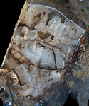
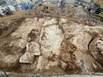
Jerusalem, Naḥal Sanhedrin (A-9101, A-9315)
Permit/License Number
A-9101, A-9315
Excavation Report
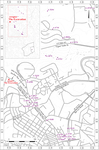
During August 2021 and November 2022, two seasons of salvage excavation were conducted along Ha-Rav Ben Ẓion Etun Street, next to Golda Meir Way in the section between Sanhedriyya and the Har Ḥoẓvim compound (Permit Nos. A-9101, A-9315; map ref. 220349–470/634145–235; Fig. 1), following the discovery of an ancient quarry in probes conducted prior to the construction of a bus parking lot (Hartom Parking Lot). The excavation, on behalf of the Israel Antiquities Authority and funded by Moriah Jerusalem Development Corporation, was directed by M. Hagbi (field photography), with the assistance of N. Nehama (administration), O. Chalaf (supervision and metal detector), M. Chernin, A. Landes-Nagar, D. Tanami and Y. Kang (supervision), K. Arbiv (metal detector), S. Halevi (photography, photogrammetry and surveying), O. Zakaim (drafting and plans) and Y. Vaknin (conservation and reconstruction of ancient quarrying methods).
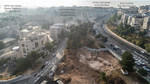
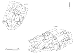
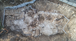
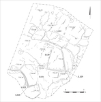
Two excavation areas, an eastern (c. 590 sq m) and a western (c. 420 sq m), were opened (Fig. 2) on the two banks of Naḥal Sanhedrin, which flows to Naḥal Ẓofim. The excavations exposed a quarry that was probably active during the first and twentieth centuries CE, and the quarrying marks indicate that it was used to extract large stones and was of the ‘Giant Quarry’ type (Safrai and Sasson 2001:5, 6). The quarry is composed of limestone of the Bi‘na formation, which combines a lower meleke layer with an upper mizzi hilu layer, separated by a fault line. The stones in the quarry were cut from the meleke layer, which was considered higher quality and easier to work, although reaching it required quarrying through the mizzi hilu layer and the fault line. Numerous cracks in the crumbling rock are visible throughout the quarry, indicating that the masons carefully selected the quarrying locations to maximize the efficient extraction of stone.
Many quarries were found in the area previously (see Fig. 1), indicating that the ridges north of the Old City were the preferred source for extracting giant stones. East of the excavation, in the nearby Sanhedriyya neighborhood, a number of large-stone quarries that were active during the first century CE were uncovered (Mizrachi 2007 [Fig. 1: A-4346]; Mizrahi 2014 [Fig. 1: A-6833]; Bar Nathan 2008 [Fig. 1: A-4827]; Finkielsztejn 2009; [Fig. 1: A-5393]; Landes-Nagar 2010 [Fig. 1: A-5410]; Zilberbod 2013a [Fig. 1: A-6508]; Zilberbod 2016 [Fig. 1: A-7495]; Sulimani 2016 [Fig. 1: A-5494]).
In a burial cave in the Sanhedriyya neighborhood, a quarry that was probably active before the cave was hewn (Kloner and Zissu 2002:237–259) was found. South of Sanhedriyya, in the Arzei Ha-Bira neighborhood, another quarry used for large stones was found (Zilberbod and Rapuano 2011 [Fig. 1: A-5759]; Sion, Rapuano and Kogan-Zehavi 2013 [Fig. 1: A-5702]; Sion and Rapuano 2013 [Fig. 1: A-5688]; ‘Adawi 2014 [Fig. 1: A-6705]; Wiegmann, ‘Adawi and Oz 2014 [Fig. 1: A-6771], and see references there; Greenwald 2015 [Fig. 1: A-6604]). A quarry was also uncovered on Road No. 1 (Zilberbod and Amit 2010 [Fig. 1: A-5521]). Other quarries were found north of the excavation, along the banks of Naḥal Ẓofim (Zilberbod 2011 [Fig. 1: A-5793]; Kisilevitz 2012 [Fig. 1: A-6076]). To the north of Naḥal Ẓofim, in the Ramat Shlomo neighborhood, a first century CE quarry was discovered, with stones of similar dimensions to those found in the present excavation (Zilberbod 2014 [Fig. 1: A-5204]). To the south of this quarry, remains of another one were found (Yeger 2018 [Fig. 1: A-8060]). North of the excavation, in the Shuʽfaṭ neighborhood, quarries of large stones were found, dated to the first century CE and the time of the Roman governor Pontius Pilate [Zilberbod 2013b [Fig. 1: A-6576]; Zilberbod 2013c [Fig. 1: A-6530]; Zilberbod 2017 [Fig. 1: A-6730]).
The Eastern Area
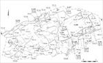
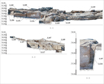
The area (Figs. 3–6; 3D model) is divided into two quarrying units, eastern and western, which are distinguished by the method of severing the blocks from the rock. Severance indents were used in the eastern unit (see below), but they were not used in the western one. Five quarrying steps (L105–L107, L109, L113) and one courtyard quarry (L108) were found in the eastern unit, and two quarrying steps (L110, L111) were found in the western unit. The height of the steps varies according to the dimensions of the quarried stones. Marks from quarrying activity conducted in the twentieth century CE (L114), which damaged the ancient quarry, were also found.
The Eastern Unit
Step 105 is the highest one in this unit, and it was used to quarry large stones (1.0–1.5 × 2.0 m). V-shaped severance channels are visible on the rock surface, and at fixed intervals (c. 0.75 m) along them, shallow oval severance indents were hewn. An iron rod with a curved end was inserted into the indents and under the stone, and upwards leverage was used to sever the stone block from the rock (Safrai and Sasson 2001:27–29 and see illustrations there). This method was commonly used to quarry smaller stones (max. length 0.2–0.3 m) than those found in the excavation.
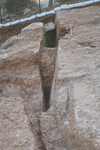
Step 106. Quarrying and severance channels of large stones were exposed. At its center was a stone block with a longitudinal crack that was also found beneath the block. The crack was caused by quarrying, and it halted activity. The crack is associated with the fault line that crosses the quarry, and it affected the direction of the quarrying and the dimensions of the stones produced. The quarrying channels are wide and deep enough for a man to stand in (L101, L115, L116; width at top 0.55 m, width at bottom 0.08–0.10 m, depth 1.5–1.7 m; Fig. 7). They were discovered near cracks and crumbling rocks, and therefore they may have served as probing channels, used to test the quality of the rock before investing effort into quarrying (Y. Vaknin pers. comm.). The identified probing channels could be those left once the rock proved unsuitable for further quarrying, and there may have been others. The probing channels were filled with stone chips from the quarrying debris.
Step 107 differs from the other steps in the eastern unit. It has severance channels with a diagonal profile that were used to sever the stone blocks without severance indents. The severance from the rock may have been achieved using iron 'splitting wedges' and 'lekhayaim'—iron slats that either used for expanding the quarrying channels or used to protect both sides of the stake while it was being struck (see, Weksler-Bdolah 2017). The severance channels indicate that extremely large stones (1.5 × 4.0 m) were quarried here. A probing channel was uncovered in the southern part of the step, and next to it there was a crack in the rock. Next to the crack, a nearly finished stone block was found, suggesting that its quarrying was affected by the crack. The rock at the upper part of the step is very worn and extensively cracked. To the west of the step, a wide fissure, which was created by the crumbling of a rock layer unsuitable for the extraction of building blocks, was found. The fissure separates the eastern and western quarrying units, except for Step 109 (see below) that is part of the eastern unit but located north of the fissure.
Courtyard 108 is a large courtyard quarry at the foot of Step 106. Severance channels are visible on the rock, with severance indents along them. The direction of the quarrying changes according to the intended size of the stone or the cracks that were found in the rock. In the western part of the courtyard, there was a block of stone that was damaged during severance, probably due to a horizontal crack in the bedrock that was not identified during quarrying. In the eastern part of the courtyard, the lower part of severance channels was found. These were left after the severance of a large stone block (1.26 × 2.50 m and probably 1.2 m high, given the height of the adjacent Step 113; see below). The size of the block matches the average dimensions of the other stones that were hewn in the courtyard, as indicated by the severance channels found in it. A probing channel (L116) was hewn next to the southwestern corner of the courtyard.
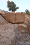
Step 109 is in the lower part of the quarry, and two large stone blocks ready for severance were found in it (1.5 × 1.6 × 1.6 m; Figs. 8, 9). A crack that may have been formed by quarrying or the natural wear of the rock was found in one of the blocks. Another possibility is that the crack is the result of roots penetrating the rock-face. A wide and deep probing channel (L118; length 3 m, width 0.8 m, depth 1 m) delineates the stone blocks from the west. At the base of one block, a severance indent was discovered, further supporting that the indents were used in this quarry to sever stones larger than previously recognized (Safrai and Sasson 2001).
Step 113 (height c. 1.2 m) is at the foot of Courtyard 108 and, like the steps next to it, contains severance channels and severance indents. The step extends east and north, outside the excavation boundaries, so it was not fully excavated. The step may have extended to the west and formed a single unit with Step 114 (see below) in the ancient quarry, which was eventually damaged during the quarrying activity of the twentieth century CE.
The Western Unit
Step 110 had severance channels, which indicate the hewing of large stones (average 1 × 2 m). No severance indents were found in the channels.
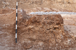
Step 111 is the widest exposed during the excavation. The quarrying marks and severance channels indicate that the stones hewn there had similar dimensions to those hewn in nearby Step 110. In the western part of the step, excavations uncovered four severance channels (L112) of a stone block that was not fully hewn for unknown reasons. A packed layer of quarrying debris (Fig. 10), comprised mostly of stone chips, was accumulated on the rock. A few pottery sherds were found in the debris and the severance channels; while predominantly unidentifiable, these seemingly date to the first century CE.
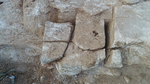
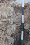
Step 114 was created during quarrying activity in the twentieth century CE, and Step 111 was damaged in the process. The step continues eastward and also damaged Step 109 and perhaps Step 113 (see above). The quarrying was carried out by vertical drilling into the rock and insertion of long explosive rods (length c. 0.6 m; Fig. 11). Such drillings can be seen throughout the entire step.
The Western Area
The area (Figs. 12–14; 3D model) includes four quarrying steps (L120–L123). It is possible to discern twentieth century CE quarrying activity that damaged the ancient steps in the southwestern part of the area.
On Step 120, north–south channels were hewn, and severance indents were identified along them. The step is delineated on the north by a raised strip of rocks with quarrying marks that was probably part of a severance channel. The channel separated Step 120 from Step 123 to its north. A courtyard quarry, bounded by vertical rock on east and south, was exposed in the eastern part of the step. At the base of the vertical rock, a quarrying channel was found (L125; width c. 0.15 m, depth 0.3 m); the channel contained quarrying debris. Severance channels and indents that indicate the quarrying of enormous stone blocks (c. 1.6 × 3.0 m) were found at the center of the courtyard. Cracks that restricted quarrying are visible on this step too. In the southern part of the step, a natural fissure in the rock separates it from Step 121.
On Step 121, a large quarrying surface with severance channels and indents was uncovered in the west. A wedge was stuck in one severance channel (Fig. 15); it could not be pulled out, and it was left in situ. The step is bounded on the west by a vertical rock wall, with a severance channel at its base (L124; width c. 0.15 m, depth 0.2–0.3 m). The rock surface is not straight since each block was extracted at a different angle and direction to accommodate the natural fissure in the north, which separates this step from Step 120.
Step 122 is the highest in this area. It was damaged by quarrying activity in the twentieth century, and a few damaged quarrying channels also remain in its western part. Its state of preservation prevents reconstructing the activity and the dimensions of the extracted stone blocks.
On Step 123, severance channels, which were oriented north–south and have severance indents, were identified. The channels are poorly preserved and barely visible on the surface; they were uncovered after a thorough cleaning of the rock. A square raised rock, which was probably prepared for severance and not extracted for an unclear reason, was uncovered in the western part of the step. Numerous karstic hollows and cracks are visible, suggesting that quarrying stopped once it became apparent that it was no longer possible to extract high quality stone blocks.
Conclusion
The quarry exposed in the excavation was a ‘Giant Quarry’ type, used to produce large stones (Safrai and Sasson 2001). The large stone blocks that were extracted were probably intended for state or monumental buildings. The quarry joins an increasingly large number of ‘Giant Quarries’ that were discovered in recent years in areas to the north of the Old City, along Bar-Lev Road (Kohn-Tavor 2010 [Fig. 1: A-5439]) and in the Bar Ilan, Sanhedriyya, Ramat Shlomo, Shu‘faṭ and Bet Ḥanina neighborhoods.
Dating the quarry based on the small quantity of pottery fragments, which include body sherds from the first century CE, is not certain. The pottery was found in a layer of quarrying debris that covered the quarry, and it can therefore only date the end of the quarry’s use. At the same time, the ‘Giant Quarries’ are unique, and there is a high probability that they served the large building projects of the first century CE (e.g. Sion et al. 2011; Zilberbod 2013a; Zilberbod 2013b; Zilberbod 2017). One of the typical characteristics of the ‘Giant Quarries’ is the probing channels, some of them found in the present excavation. Similar probing channels were found, for example, in the quarry at nearby Ramat Shlomo (Zilberbod 2014), which was dated based on coins that were found in the base of the probing channels to the days of the governors, the latest of them being Pontius Pilate; it was recently suggested that some of the large building projects in Jerusalem continued into his time (Szanton et al. 2016; 2019).
The stones that were produced in the quarries (c. 740 m asl) were transported to the area of the Temple Mount, to their south and at a lower elevation (734 m asl). The transport routes followed a topographic line that had a relatively uniform elevation, supporting convenient transport of the giant stones. Based on the concentration of quarries, it may be suggested that the stones were transported through the Bar Ilan axis and another axis that passed between Shemu’el Ha-Navi Street and Bar-Lev Road, and from there they were transported toward the Old City (see Fig. 1).
Quarrying in this area was renewed in the twentieth century. Drillings similar to those exposed in the excavation were also exposed along Naḥal Ẓofim, north of the excavation area. These drillings are probably associated with the activity of the ‘Jerusalem Quarry,’ which was active from the first half of the twentieth century CE until the foundation of the Hi-Tech Park west of the excavation. The quarry is also mentioned in a letter from the Mattersdorf neighborhood residents to the Jerusalem municipality that protests the noise of the quarrying activity, which used dynamite sticks that were inserted into drill-holes in the rock (Chalaf, Hagbi and Berko 2023; State Archive, file ‘GL 5566/28, the Ministry of Housing, Israel Land Administration, the Jerusalem Quarries, pp. 74–85).
References
‘Adawi Z. 2014. Jerusalem, Arzei Ha-Bira. HA–ESI 126. https://doi.org/10.69704/jhaesi.116.2004.8503
Bar-Nathan R. 2008. Jerusalem, Sanhedriyya. HA-ESI 120. https://doi.org/10.69704/jhaesi.116.2004.861
Chalaf O., Hagbi M. and Berko I. 2023. The Continuity of Use in the Modern Era of Ancient Quarries Northern Jerusalem. In E. Meiron ed. City of David Studies of Ancient Jerusalem 18. Jerusalem. Pp. 103–122 (Hebrew)
Finkielsztejn G. 2009. Jerualem, Nisan Beck Street. HA-ESI 121. https://doi.org/10.69704/jhaesi.116.2004.1072
Greenwald R. 2015. Jerusalem, Arzei Ha-Bira. HA-ESI 127. https://doi.org/10.69704/jhaesi.116.2004.16734
Kisilevitz S. 2012. Jerusalem, Naḥal Ẓofim. HA-ESI 124. https://doi.org/10.69704/jhaesi.116.2004.2028
Kloner A. and Zissu B. 2003. The Necropolis of Jerusalem in the Second Temple Period. Jerusalem (Hebrew).
Kohn-Tavor A. 2010. Jerusalem, Barlev Road. HA-ESI 122. https://doi.org/10.69704/jhaesi.116.2004.1311
Landes-Nagar A. 2010. Jerusalem, Sanhedriyya Murḥevet. HA-ESI 122. https://doi.org/10.69704/jhaesi.116.2004.1304
Mizrachi Y. 2007. Jerusalem, Nisan Beck Street. HA–ESI 119. https://doi.org/10.69704/jhaesi.116.2004.620
Mizrahi S. 2014. Jerusalem, Maḥanayim Street. HA–ESI 126. https://doi.org/10.69704/jhaesi.116.2004.10577
Safrai Z. and Sasson A. 2001. Quarrying and Quarries in the Land of Israel. Elkana (Hebrew; English summary, pp. 115–117).
Sion O. and Rapuano Y. 2013. Jerusalem, Shemu’el Ha-Navi Street. HA-ESI 125. https://doi.org/10.69704/jhaesi.116.2004.4359
Sion O., Rapuano, Y. and Kogan-Zehavi E. 2013, Jerusalem, Arzei Ha-Bira. HA-ESI 125. https://doi.org/10.69704/jhaesi.116.2004.4358
Sion O., Sasson A., Zilberbod I. and Rapuano Y. 2011. Quarries and Quarrying Methods in the Second Temple Period in the North of Jerusalem. In M. Bilig, ed. Judea and Samaria Studies 20. Jerusalem. Pp. 39–48 (Hebrew).
Sulimani G. 2016. Jerusalem, Sanhedrin Street. HA-ESI 128. https://doi.org/10.69704/jhaesi.116.2004.25155
Szanton N., Hagbi M., Haber M., Uziel J. and Ariel D.T. 2016. Monumental Building Projects in Jerusalem in the Days of Pontius Pilate: A Numismatic View from the Stepped Street in the Tyropoeon Valley. In G.D. Stiebel, J. Uziel, K. Cytryn-Silverman, A. Re’em and Y. Gadot eds. New Studies in the Archaeology of Jerusalem and its Region: Collected Papers 10. Jerusalem. Pp. 99–114 (Hebrew).
Szanton N., Hagbi M., Uziel J. and Ariel D.T. 2019. Monumental Building Projects in Jerusalem at the Days of Pontius Pilate – A View from the Stepped Street. Tel-Aviv 46:147–166.
Weksler-Bdolah S. 2017. A Cache of Iron Quarrying Tools from Excavations near Jerusalem’s Third Wall (Hebrew, pp. 1*–8*; English summary, pp. 153–154). https://doi.org/10.70967/2948-040X.1794
Wiegmann A., ‘Adawi Z. and Oz L. 2014. Jerusalem, Arzei Ha-Bira. HA-ESI 126. https://doi.org/10.69704/jhaesi.116.2004.12637
Yeger D. 2018. Jerusalem, Ramat Shelomo. HA-ESI 130. https://doi.org/10.69704/jhaesi.116.2004.25467
Zilberbod I. 2011. Jerusalem, Naḥal Ẓofim. HA-ESI 123. https://doi.org/10.69704/jhaesi.116.2004.1844
Zilberbod I. 2013a. Jerusalem, Sanhedriya. HA-ESI 125. https://doi.org/10.69704/jhaesi.116.2004.2264
Zilberbod I. 2013b. Jerusalem, Shuʽfaṭ. HA-ESI 125. https://doi.org/10.69704/jhaesi.116.2004.4356
Zilberbod I. 2013c. Jerusalem, Shuʽfaṭ. HA-ESI 125. https://doi.org/10.69704/jhaesi.116.2004.4383
Zilberbod I. 2014. Jerusalem, Ramat Shlomo. HA-ESI 126. https://doi.org/10.69704/jhaesi.116.2004.13706
Zilberbod I. 2016. Jerusalem, Sanhedriyya. HA-ESI 128. https://doi.org/10.69704/jhaesi.116.2004.25069
Zilberbod I. 2017. Jerusalem, Shu‘faṭ (Highway 21) HA–ESI 129. https://doi.org/10.69704/jhaesi.116.2004.25194
Zilberbod I. and Amit D. 2010. Jerusalem, Highway No. 1. HA=ESI 122. https://doi.org/10.69704/jhaesi.116.2004.1609
Zilberbod I. and Rapuano Y. 2011. Jerusalem, Arzei Ha-Bira. HA-ESI 123. https://doi.org/10.69704/jhaesi.116.2004.1875
Keywords
Giant quarry, Nahal Sanhedrin, Sanhedriyya, Building stones, First Century CE, Severance indents, Probing trenches, Temple Mount
Publication Date
03/08/2026
Report Type
Final Report