Jerusalem, Western Wall Plaza (A-9317, A-9796)
Permit/License Number
A-9317, A-9796
Excavation Report
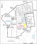
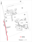
During July 2022 and July 2024–January 2025, two seasons of salvage excavations were conducted in the western part of the Western Wall Plaza, Jerusalem (Permit Nos. A-9317, A-9796; map ref. 222191–209/631504–553; Fig. 1), prior to development. The first excavation season lasted two weeks and was stopped for safety concerns. The second excavation season lasted six months, and it was stopped because of weather conditions. The excavations, on behalf of the Israel Antiquities Authority and funded by the Western Wall Heritage Foundation, were directed by S. Weksler-Bdolah (field photography), with the assistance of M. Chocron (area supervision in the 2024 season), N. Nehama (administration), V. Essman (surveying), S. Halevi (photogrammetry), D. Yeger (metal detector), A. de Vincenz (pottery), Y. Gorin-Rosen (glass), L. Sandberg (numismatics) and workmen on behalf of the contractor (Shoham Engineering & Development Ltd.), most of them tour guides. The Jerusalem District and the Western Wall Heritage Foundations rendered considerable assistance.
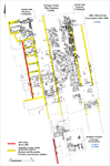
The excavation (c. 15 × 20 m) extended on the northeastern slope of the western hill of ancient Jerusalem, which encompasses the Jewish Quarter, the Armenian Quarter and Mount Ẓion, c. 100 m west of the Western Wall of the Herodian Temple Mount and along the axis of Ha-Gai Street (el-Wad), which was dismantled when the Western Wall Plaza was paved in 1967. This street preserved the axis of the Eastern Cardo of Aelia Capitolina, Roman-period Jerusalem. The excavation area was opened at the foot of an impressive hewn cliff. The cliff delineates the Western Wall Plaza on the west; at its top is Aish HaTorah Yeshiva. Extensive excavations conducted north of the excavation area during 2005–2020, prior to the construction of Beit Haliba (Fig. 2; Weksler-Bdolah et al. 2009; Weksler-Bdolah, Kisilevitz and Onn 2015; Weksler-Bdolah and Onn 2019; Weksler-Bdolah 2021), unearthed ancient remains that were attributed to 15 archaeological strata, dated from the end of the First Temple period (eighth–sixth centuries BCE) until present. These remains include an ancient quarry and, above it, a building of the ‘four-room house’ type dated to the First Temple period (seventh century BCE); extensive sections of the Eastern Roman Cardo, which was paved on a north–south axis in the second century CE and maintained its route until the twentieth century CE, while having been raised by c. 4 m and narrowed from 24 m to 2.5–3.0 m; buildings from the Early Islamic period that were built along the street, narrowing it; and the Mughrabi neighborhood houses that were built in the late twelfth/thirteenth century CE and remained in constant use until 1967 (Weksler-Bdolah and Onn 2019:15, Table 1.1).
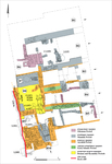
The present excavation (Fig. 3) reached 4 m below the Western Wall Plaza and exposed remains from the Roman, Byzantine, Early Islamic (ninth–tenth centuries CE), Ayyubid and Mamluk (late twelfth/thirteenth–fifteenth/sixteenth centuries CE), Ottoman (seventeenth–eighteenth/nineteenth centuries CE) and late Ottoman (nineteenth–twentieth centuries CE) periods as well as modern times. The excavation did not reach bedrock.
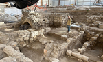
Modern soil fills that accumulated at the foot of the quarried cliff were cleared prior to the excavation. The primary remains uncovered in the excavation consist of an impressive complex of buildings from the Mughrabi neighborhood that were found beneath the paving of the Western Wall Plaza. Among the remains, there are elongated halls roofed with slightly pointed vaults and arches. The halls, oriented east–west, were probably entered from Ha-Gai Street (el-Wad), whose assumed axis is to the east and outside the excavation boundaries. The upper story of the buildings was removed with mechanical equipment after the Six Days War, while the ground floor, with parallel halls, was exposed in the present excavation. Soil fills containing a large quantity of small finds from the Mamluk and Ottoman periods were found over floors and installations inside the halls. In the western part, the halls abut a series of rooms that were built on a north–south axis along the lower part of the hewn cliff. An ancient barrel vault was found beneath one of the rooms, dating probably to the Roman period. Below it, another barrel vault was discovered, which probably served as a cistern. Its lower part was likely hewn into the bedrock, and its walls were plastered. At the time of excavation, its bottom was filled with water.
The Roman and Byzantine Periods
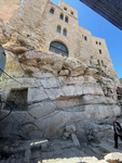
The Hewn Rock Cliff. The vertical cliff on the western boundary of the excavation area was quarried on a north–south axis, apparently during the Roman period (Fig. 4). The northern part of this cliff (length 19 m, max. height 11 m) was found in previous excavations approximately 15 m north of the current excavation, and its design as an upright rock wall was attributed to preparatory work prior to paving the Roman cardo along this axis in the second century CE (Weksler-Bdolah 2019b:35). Another section of the cliff (length c. 11.5 m, height c. 7 m) was discovered in the present excavation, although it did not directly continue the previously identified cliff line and was c. 6 m to its east (see Fig. 2). The upper part of the cliff was not documented so far, and its bottom was not uncovered. The Low-Level Aqueduct of the Second Temple period, which was hewn in the rock, was previously recorded at the top of the cliff (its bottom at height 737.5 m asl; Weksler-Bdolah 2019a:24–25), and the cliff was presumably hewn in accordance with the route of the Aqueduct to preserve it. The northern section of the cliff discovered in prior excavations aligned with the western (back) wall of the row of shops built west of the cardo’s western colonnade. However, in the current excavation, the cliff section was found at the western boundary of the western colonnade, and it negated the western row of shops, unless they were hewn as subterranean cells in the rock (not yet discovered). The quarrying along the cardo may have been influenced by the route of the Low-Level Aqueduct, which the Romans wanted to preserve, and as a result, the deviation in the cliff line was caused. In the southern part of the recently exposed cliff, two hewn square depressions (L1011, L2009, see Fig. 4) were discovered, likely representing installations of undetermined function. The floor of both installations (731.5–731.8 m asl) was 4–5 m above the estimated level of the cardo and the western colonnade, and they may have been hewn after the Roman period.
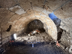
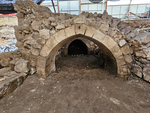
Built Vaults. A barrel vault, oriented north–south (W2096; length c. 7 m, width c. 3.5 m, internal height 3 m; Fig 5), was unearthed along the foot of the cliff. It was probably built on the floor level of the western colonnade of the Roman cardo. Underneath this floor was the top of another barrel vault (W2110; internal height c. 6 m), which was also built on a north–south axis at a lower level; it was plastered and served as a water reservoir, but it was not excavated.
Vault 2096 was partially filled with soil, and was only partly excavated. The vault was built of large ashlars (0.40–0.50 × 0.55–0.60 × 0.70–1.20 m) with smoothed surfaces. The stones were laid in straight courses, one besides the other, with no visible bonding material. The western wall of the vault was built along the hewn cliff (W2088), and in the eastern wall, two entrances that were later blocked are visible. At this moment, it is not possible to determine whether these were original entranceways or later breaches. Several recesses were hewn in the vault’s walls and its ceiling, perhaps to anchor installations. At the time of its construction, Vault 2096 was open to the north and closed or partially open to the south. At present, this cannot be determined with certainty. The vault was eventually closed with walls in its northern and southern ends; those walls were partly exposed.
In the bottom of Vault 2096, along its northern boundary, there was an opening for drawing water, which was integrated into the roof of Vault 2110 below it. The barrel-like outline of Vault 2110, whose lower part was apparently hewn into the rock, was identified through this opening. Vault 2110 extended beyond the boundary of Vault 2096 to the north. Its walls and the vaulted roof were plastered with gray hydraulic plaster, and at the time of the excavation, water was visible at the bottom of the reservoir. Vault 2110 was likely sealed by the pavement of the western colonnade of the Roman cardo, like other Roman and Byzantine-period cisterns that were previously documented beneath the western colonnade of the Eastern Roman Cardo (Weksler-Bdolah 2019b:60–61, Plan 3.3: L300, L712). So far, it was not possible to access Vault 2110, so its construction date is not known with certainty, but it can be assumed that it dates from the Roman period at the earliest.
The Early Islamic, Ayyubid and Mamluk Periods
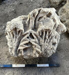
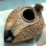
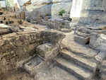
An impressive complex of buildings, which was most likely associated with the Mughrabi neighborhood that was located here from the late twelfth/thirteenth century CE until 1967, was found in the excavation area above and beside Vault 2096. Five elongated halls, oriented east–west (Fig. 3: H1–H5), were partly unearthed. Their western side abutted a long narrow north–south oriented space, which was built along the rock cliff above earlier vaults and was divided into rooms, perhaps courtyards (Fig. 3: H6–H9). The entranceways of Halls H1–H5 were likely from Ha-Gai Street (el-Wad) on the east, but they were not yet found. The floors of the halls were at a lower level than the floors of the western row of rooms. Currently, the upper part of the buildings’ walls was exposed, including pointed arches that were integrated within the walls and roof-vaults, some preserved completely and others collapsed (Fig. 6). Many construction phases were discernible in the walls of the buildings, including building extensions, wall reinforcements, entrance blockages and more. Numerous architectural elements were integrated into the buildings in secondary use, especially doorpost fragments and paving stones. A Corinthian capital was secondarily used within the core of one wall (Fig. 7); its finishing is similar to Roman-period capitals that were found incorporated in an Early Islamic-period wall, which was built above the Eastern Cardo c. 30 m north of the current excavation (Peleg-Barkat 2019:133–135, Figs. 4.14, 4.15). Within one of the dismantled walls, an intact Early Islamic-period lamp was found (Fig. 8). Additionally, segments of packed-earth, plaster and stone floors were preserved in the covered halls, in open spaces, which perhaps served as courtyards or alleyways, and on staircases. Most of the finds were attributed to the Ayyubid and Mamluk periods, but most likely the buildings were used from the Early Islamic period as was previously identified in the excavations of Beit Haliba.
Halls H1–H5. Hall H1 was not excavated yet. In Hall H2, remains of prominent pilasters that supported pointed arches were discovered, indicating that the hall was originally roofed with a system of cross vaults. These collapsed at some point, after which the hall served as an open courtyard between structures, and several installations were built within it. In the center of the yard, the excavations revealed remains of a smelting furnace (L2155) containing globular iron lumps, a type of ingot. West of the furnace, several poorly preserved installations were exposed. Mamluk-period pottery fragments were found in a layer of soil that sealed the installations, providing an approximate date.
Hall H3 was divided into units, some retaining complete roof vaults (Fig. 9). The floor of the hall was not exposed yet. An accumulation of soil rich in small finds was found in this space, including a rare hoard of 18 silver coins from the thirteenth–fourteenth centuries CE.
Hall H4 was narrower than the other halls (min. length 9 m, width 2 m) and may have functioned as a corridor between Halls H3 and H5.
Narrow walls divide Hall H5 into small rooms. High quality plaster floors were found in these rooms.
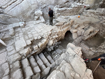
Rooms H6–H9. Between the halls and the cliff, a narrow space was built on a north–south axis and divided into four rooms. The floor level of these rooms was laid above the Roman-period vaulted roof that survived intact. Room H6, the most northern room, was a stone-paved courtyard, which was reached by a staircase from Hall H2 in the east (Fig. 10). The opening of a cistern was found in the center of the courtyard, and it was covered by a stone wellhead made of a reused ancient column base. The pumping shaft extended down to the northern part of the underground Roman Vault 2210 (total depth of the pumping shaft and the cistern reaches 10 m).
Rooms H7 and H8 were built inside a partially preserved barrel vault (W1014; length c. 6 m, width c. 4 m) that was built on top of the Roman–Byzantine Vault 2096, which was extended northward using an arch (W2060; width 1.5 m), and its space was enclosed on the north by a wall (Fig. 5). The upper Vault 1014 was paved with plaster (L2047, L2071). In the bedding of its floor, a hoard containing three Mamluk gold coins minted in the fifteenth century CE was discovered. An opening for drawing water that was integrated in Floor 2047 (Room H7), descended through Vault 2096, into Vault 2110.
Room H9 was a stone-paved courtyard (L2070; Fig. 11) located south of Vault 1014, separated from it by an entrance. The courtyard was built on lower roofed spaces that were partially uncovered. The eastern part of the floor of Courtyard 2070 was dismantled at some point. A staircase (L2103; Fig. 3: H10) was built in its place, descending northward from the courtyard. This staircase provided access to two lower areas: Vault 2096, which had remained in use since the Roman period, and Hall H5. During this phase, Hall H5 was subdivided into several parts.
The Ottoman Period (Fig. 12)
Thin layers of packed earth (L2078) that was probably a floor were found in Hall H4. A partially preserved ṭabun (L2111) and narrow walls of installations were found in these layers. Within the compacted earth levels of L2078, dozens of clay pipe fragments were discovered; the majority of these were of local manufacture, along with several ‘Kurdish’ type tobacco pipes and one made of bone (ivory?). Considering this, a coffee shop may have existed on or near the premises.
Soil accumulations rich in small finds from the Mamluk and Ottoman periods were found in Halls H2, H3 and H5.
The Late Ottoman Period (Fig. 12)
In the courtyard of Hall H2, a white plaster floor (L2058), was uncovered. It was comprised of several layers, indicating several building phases or renovations. The southwestern side of Floor 2058 abutted the staircase that ascended west towards Room H6, which served as a courtyard. During the late use phase of Floor 2058, the staircase went out of use, and Floor 2058 was covered in white plaster and sloped upward as a ramp towards courtyard H6. The ramp probably facilitated the movement of livestock to the cistern in courtyard H6. During this phase, or earlier, a stone trough (L2055) was placed next to the staircase; it was similarly covered with white plaster.
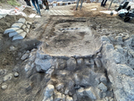
In Hall H5 a rectangular pool-like installation plastered with gray plaster (L2022; 1.8 × 2.5, preserved height 0.2 m; Fig. 13) was built; only its lower part was preserved beneath the modern paving. The installation was delineated by narrow walls built of a single row of stones. On its northern side, the installation adjoined the wall of Hall H5. The bedding of the installation was made of a layer of ash and charcoal, and beneath it a dense fill of medium-sized fieldstones. East of Installation 2022, meager wall remains were found, perhaps parts of additional installations.
Modern Day
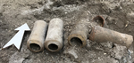
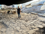
Collapsed buildings of the Mughrabi neighborhood were found over the floor of Hall H2 and courtyard H6; it is obvious that they were piled using mechanical equipment. The collapse-heaps were sealed below the Western Wall Plaza. Small terracotta water pipes of the kizan type that were originally incorporated into balustrades or domes of the Ottoman-period buildings to facilitate ventilation (Fig. 14), were found in the collapse-heaps. Paving of irregular stone slabs (L2007; preserved area 9.0 × 12.5; height 730.67 m asl) that were set side by side with no mortar (Fig. 15), was discovered at the foot of the cliff and above the western part of Halls H3–H5. Between the stones of the paving and in a sealed fill below it, coins dating to 1968 and a tube of military jam from November 1968 were found, showing that the plaza was not paved before late 1968. The location of the plaza is high and prominent, overlooking the Western Wall and Temple Mount. Photographs of the area from this time show that the Western Wall Plaza was not completely paved by then, and Paving 2007 may have served as a special gathering place. Paving 2007 went out of use when a later plaza was paved on a higher level (L2006; 731.5 m asl). Plaza 2006 was paved with modern sawn stone slabs, which were preserved in a small segment of the southeastern part of the excavation at the level of the current Western Wall Plaza.
Conclusion
The excavation area extended along the route of the Eastern Roman Cardo, which was a primary traffic route in Jerusalem from the Roman period (second century CE) until the paving of the Western Wall Plaza after 1967. The remains attest to the importance of the Hasmonean (Hellenistic) Low-Level Aqueduct, that was preserved along the edge of a hewn vertical cliff (minimum height 17 m). The cliff was likely hewn during the Roman period, as part of preparation works for the construction of the Eastern cardo. At the foot of the cliff, three barrel vaults were built one over the other. The lower part of the lowermost vault was presumably hewn into the rock and used as water reservoir. Water still accumulate in it (its estimated depth bottom c. 720.5 m asl).
The impressive building complex that was attributed to the Mughrabi neighborhood and the rich small finds assemblage, including two hoards of silver and gold coins from the Mamluk period (thirteenth–fifteenth centuries CE), indicate the affluent status of the city’s residents in general and the Mughrabi neighborhood in particular during this period.
The excavation has not reached bedrock yet, and it is assumed that additional remains are found at deeper levels.
References
Peleg-Barkat O. 2019. Architectural Decoration of the Eastern Cardo. In S. Weksler-Bdolah and A. Onn. Jerusalem, Western Wall Plaza Excavations I: The Roman and Byzantine Remains: Architecture and Stratigraphy (IAA Reports 63). Jerusalem. Pp. 117–146. https://doi.org/10.69704/iaaRepV000.1996.12
Weksler-Bdolah S. 2019a. Remains of the Second Temple Period (Stratum XIII). In S. Weksler-Bdolah and A. Onn. Jerusalem, Western Wall Plaza Excavations I: The Roman and Byzantine Remains: Architecture and Stratigraphy (IAA Reports 63). Jerusalem. Pp. 17–28. https://doi.org/10.69704/iaaRepV000.1996.12
Weksler-Bdolah S. 2019b. The Eastern Cardo in the Roman and Byzantine Periods (Strata XII–X). In S. Weksler-Bdolah and A. Onn. Jerusalem, Western Wall Plaza Excavations I: The Roman and Byzantine Remains: Architecture and Stratigraphy (IAA Reports 63). Jerusalem. Pp. 29–88. https://doi.org/10.69704/iaaRepV000.1996.12
Weksler-Bdolah S. 2021. Jerusalem, the Old City, Western Wall Plaza. HA-ESI 133. https://doi.org/10.69704/jhaesi.116.2004.25927
Weksler-Bdolah S., Kisilevitz S. and Onn A. 2015. Jerusalem, Western Wall Plaza. HA-ESI 127. https://doi.org/10.69704/jhaesi.116.2004.18755
Weksler-Bdolah S. and Onn A. 2019. Jerusalem, Western Wall Plaza Excavations I: The Roman and Byzantine Remains: Architecture and Stratigraphy (IAA Reports 63). Jerusalem. https://doi.org/10.69704/iaaRepV000.1996.12
Weksler-Bdolah S., Onn A., Ouahnouna B. and Kisilevitz S. 2009. Jerusalem, the Western Wall Plaza Excavations, 2005–2009. HA-ESI 121. https://doi.org/10.69704/jhaesi.116.2004.1219
Keywords
Mughrabi neighborhood, Mamluk Period, Ottoman Period, Roman Eastern Cardo, Low-Level Aqueduct, Roman Period, Barrel Vaults, Hoard
Publication Date
03/08/2026
Report Type
Preliminary Report