Dalton (A-8960, A-9368)
Permit/License Number
A-8960, A-9368
Excavation Report
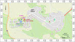
During February–March 2021, a trial excavation was carried out at Moshav Dalton, followed by a salvage excavation in August 2022 (Permit Nos. A-8960, A-9368; map ref. 245278–492/769062–218; Fig. 1), prior to widening the road and laying a sewage pipeline. The excavations, on behalf of the Israel Antiquities Authority and funded by the Ministry of Construction and Housing, were directed by M. Bekker-Shamir (trial excavation, field photography) and N. Silverberg (salvage excavation, field photography), with the assistance of E. Bron (area supervision, preliminary survey, pottery consultation), Y. Yaakobi (administration), A. Kleiner (photogrammetry), U. Berger (dolmens), A. Shapiro (location map), E. Dalali-Amos (plan), N. Getzov (pottery consultation), P. Spivak (flint tools), H. Tahan-Rosen (pottery drawing), A. Shikhman (excavation), A. Ram-Greenstein (metal laboratory), I. Peters (copper analysis), R. Be’eri (scientific consultation), and workers from Kafr Yasif, Bir el-Maksur and Sha‘ab.
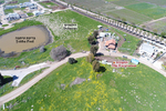
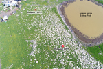
The excavations were carried out at the archaeological site of Dalton (West), next to Moshav Dalton. The site extends along the Ramat Dalton plateau (c. 830 m asl), formed by Upper Pliocene basalt flows, and the area is characterized by basalt rock outcrops, arable soil, and plentiful water sources, including Naḥal Dalton and three seasonal ponds, rendering the area congenial for settlement (Frankel et al. 2001:2–3). The Teiṭba pond, located c. 80 m west of the excavation (Fig. 2), preserves the name of the Arab village that overlay the ancient ruins (Frankel et al. 2001:39, Site 314). The ancient north–south road from Tel Qedesh, the major Early Bronze Age tell site, to the Lake of Galilee, passes near the site (Wachtel 2018:139, Site 15), this road serving as the major route in later periods.
Surveys and excavations have been carried out in this area since the late nineteenth century CE, exposing remains from the Bronze and Iron Ages, and the Late Roman, Byzantine, Mamluk and Ottoman periods (Guérin 1880:443–444; Conder and Kitchener 1881:197; Frankel et al. 2001: Site 317; Smithline 2008; Bron 2009; Sabar 2017; Wachtel 2018).
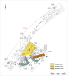
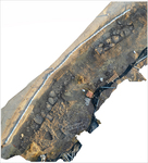
This was the first excavation at the Dalton (West) site, comprising eight excavation squares (Figs. 3–5), and yielding remains from three periods: Late Chalcolithic building remains (Stratum III), two Early Bronze II buildings (Stratum II), and pottery dated to the Umayyad period (Stratum I). In addition, Middle Bronze II pottery sherds were found scattered on the surface. The preliminary documentation of three dolmens located in the moshav and near the excavation was undertaken during the excavation (Figs. 1:1–3; 2; see U. Berger, below).
Stratum III—Late Chalcolithic Period
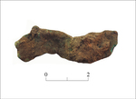
A wide wall, built of two rows of medium-sized fieldstones with small-stone fill, was extant for one course (W104, width 0.9 m; Fig. 3). The wall was dated by the associated pottery to the Late Chalcolithic period (see below). An unidentified copper object (L114, B1057; Fig. 6), found on the bedrock close to the wall, was identified by XRF analysis as pure copper. The source of pure copper in the southern Levant was the Chalcolithic and Early Bronze Age mines at Faynan (Buchman 2018:12; Ackderfeld et al. 2020), and the pure copper was exploited to manufacture tools, such as chisels and axes (Tadmor 1995:100); however, pure copper was also used in later periods.
Stratum II—Early Bronze II
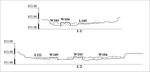
The walls of two buildings (Buildings 1, 2) were built directly on the bedrock of two rows of medium-sized field stones with small-stone fill, and were preserved for one course (W103, W109, W110; width 0.6–0.8 m; Fig. 3). Building 1 was rounded (diam. c. 5 m), partly enclosed by curved W103, some of whose stones were dismantled. A floor of medium-sized flat stones (L105) abutted the wall, and it seems that Stratum III W104 was also integrated as part of the floor. A complete limestone mortar (Fig. 13:2) found in the building, probably lay on the floor, although this was not ascertained in the excavation. The building was dated by the pottery to Early Bronze II (see below). Building 2 was partly enclosed by two walls (W109, W110) that formed a triangular shape (c. 1.5 × 3.0 m), and a floor of small stones, covering all the floor (L111), abutted the walls. This small building may have served as a granary or cellar, its stone-paved floor intended to prevent the entrance of rodents. The building was also dated to Early Bronze II by the pottery (not illustrated).
A layer of small and medium-sized stones (L121) was exposed west of the buildings, continuing a basalt outcrop (L119). This area was severely damaged and only partially excavated (and therefore not colored in Fig. 3), and it may possibly have been associated with W110 that continued in this direction. A soft limestone oval mortar (B1018) was found between the stones of L121. Stone Layer 121 sloped down west, and it was apparently damaged by the Stratum I accumulation and by the adjacent modern road bedding.
Stratum I—Umayyad Period
A heap of collapsed stones from the two, presumably destroyed, Early Bronze II buildings, was uncovered in the northern part of the excavation area (L108), and an earth accumulation layer containing Umayyad-period pottery sherds was found here. Stone Layer 121 was probably also damaged at this time.
Pottery
Many pottery sherds (n = 710) were retrieved in the excavation, of which 71 were diagnostic.
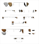
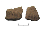
The Chalcolithic-period local pottery was characterized by light yellowish fabric with organic inclusions and a dark core, and comprised closed vessels, such as, a jar (Fig. 7:1) and a holemouth vessel (Fig. 7:2). The Chalcolithic-period assemblage also included pottery made of Golan Ware, predominantly body sherds with rope decoration (Fig. 8) and triangular handles (Figs. 7:3). The Early Bronze II pottery was made of reddish-brown fabric with lime inclusions, and included characteristic platters with in-turned rims (Fig. 7:4), jars, one with soot marks on the rim (Fig. 7:5) and flat bases (Fig. 7:6). The Middle Bronze II pottery, found on the surface, was made of a reddish fabric containing lime and grog inclusions, and comprised mainly bowls (Fig. 7:7) and platters (Fig. 7:8). A few Umayyad-period pottery sherds included jars (Fig. 7:9).
Flint Assemblage
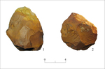
Many flint items (n = 267) were collected, predominantly made of light white-beige flint (Table 1). Twenty items seem to have been washed to the site from a considerable distance, since they were in secondary deposition, mostly worn, and covered with orange-brown double patina; they date to the Lower Paleolithic period. Two handaxes manufactured on thick flakes (length 7–8 cm, width 6 cm; Fig. 9:1, 2) were identified, their small dimensions possibly suggesting an origin in an Acheulo-Yabrudian site in the region of the Galilee, Syria or Lebanon (Zaidner and Evron 2006, and see references there).
Most of the flint assemblage is characteristic of Chalcolithic-period and Early Bronze Age sites in the area. Chunks form the largest group, followed by flakes and primary flakes that are much more common than blades and primary blades, although items manufactured on blades, including sickle blades, were more common in the salvage excavation (Permit No. A-9368; see Table 1).
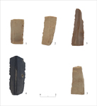
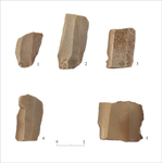
Cores and core-debitage were found in similar proportions in both excavations. Most of the cores are small and were used to exhaustion, and all have two striking platforms, and on average, seven flaking scars of small flakes. Prominent among the tools are ones made on blades, most (seven) sickle blades (Fig. 10:1–4), with sheen on one active edge (Fig. 10:1, 2), only two showing sheen on both edges (Fig. 10:3, 4). The active edge is usually retouched or lightly nibbled. The opposite edge of three sickle blades is not shaped (Fig. 11:1), and two have an abrupt (not illustrated), or semi-abrupt back (Fig. 11:2).
Six additional tools made on blades were found, most were medial fragments, four with an active retouched edge (Fig. 11:3, 4) and two truncated (Fig. 11:5). These features usually characterize sickle blades, and these items were possibly not used long enough to develop sheen. Such sickle blades are known from Chalcolithic and Early Bronze Age sites in the north (Rosen 1997:44–45, Fig. 3.11:6–10, and see references there). They were manufactured from pre-Canaanite prismatic cores (max. length 0.1 m), made from flint chunks collected in the vicinity. The additional tools are two side scrapers and a notch, manufactured on thick flakes (not illustrated). All the tools were made of local flint.
The flint assemblages represent primarily local ad-hoc industry, typical of the Chalcolithic period and Early Bronze Age in the region. A small part of the assemblage comprises washed items, whose origin seems to be in the Lower Paleolithic sites in the vicinity.
Stone Objects
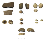
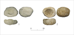
Ten objects were found, five complete; four limestone, three basalt, one flint, one pebble and one quartz geode. The objects include a broken lower grinding stone, a broken pestle, three hammerstones, one complete and two broken, a small polishing tool, a broken weight, and three mortars, two complete and one broken. The lower grinding stone is made of compact basalt and has a flat section (Fig. 12:1); it was integrated into W103, and may have originated in Stratum III. The pestle, a surface find, is made of dense basalt and has striking marks (Fig. 12:2). All the hammerstones (Fig. 12:3–5), two found on the bedrock and one on the surface, have striking marks on one active face only; one is made of flint, one of geode, and one a pebble. The polishing tool (Fig. 12:6), found on the surface, is made of limestone and has one active face. The weight, found whilst cleaning W104, is made of basalt (Fig. 12:7). The three mortars were found on the surface and in earth accumulations on the bedrock; two chalk mortars are slightly oval (Fig. 13:1), and one hard limestone mortar has the beginning of an additional depression on its base (Fig. 13:2).
Dolmens
The mapping of dolmens in Upper Galilee has hardly been updated since the pioneering early twentieth-century studies (Mader 1914; Turville-Petre 1927), apart from a few specific spots and studies in the Upper Galilee hills; Prausnitz 1960; Druks and Moskowitz 1968; Bron 2009; Stepansky 2014; Berger and Sharon 2018). In the absence of recent excavations and documentation, our knowledge about the dolmens in the vicinity and their dating is inadequate (Hartal 1987; Vinitzky 1992; Fraser 2018).
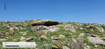
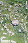
The three dolmens documented next to the excavation are the only, and possibly the last ones extant in the area (see Fig. 1:1–3). It seems that here, as also the Alma dolmen field to the north (Prausnitz 1960), large-scale destruction of dolmens was carried out in the course of contemporary development and construction. Dolmens 1 and 2 were uncovered on the bank of the Teiṭbata pond (Fig. 14), and Dolman 3 was found on the southeastern hillslope surrounding Moshav Dalton (see Fig. 1:3).
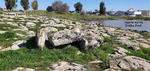
Dolmen 1 (map ref. 769120/245291; Fig. 15) was constructed as a trilithon, classified as Epstein’s Type 1b (Epstein 1985:23–25). It includes a rectangular burial chamber (c. 1.5 × 4.0 m), with an entrance facing southwest. The cell is surrounded by a curved stone wall (diam. c. 6 m) and roofed with a single stone slab (0.35 × 1.25 × 1.80 m).
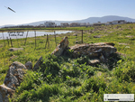
Dolmen 2 (map ref. 769101/245221; Fig. 16) was recorded in a previous survey (Bron 2009: Fig. 1:17). As Dolmen 1, it was built as a trilithon, also classifying as Type 1b. At its center there is a square burial chamber (c. 1.6 × 1.6 m), with an entrance facing east. It is roofed with a single stone slab (0.5 × 1.8 × 2.8 m).
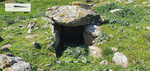
Dolmen 3 (map ref. 769345/245910; Figs. 17–19), is classified as Epstein’s Type 3 (Epstein 1985:23–25). The dolmen has a rectangular burial chamber (c. 1.1 × 2.5 m, height c. 1 m), sunk into the ground, with an entrance facing east; it was obviously cleared in a recent looting excavation. It is surrounded by a curved stone wall (diam. 6 m), roofed by a single stone slab (0.5 × 1.8 × 2.1 m).
Summary
The excavations exposed remains of a rural settlement that existed next to Teiṭbata pond in two periods—the Late Chalcolithic and the Early Bronze. The Late Chalcolithic settlement included a wide wall, perhaps part of a building, with a household assemblage of storage and cooking pottery vessels, and stone and flint tools to process agricultural produce. The Early Bronze II settlement included remains of buildings, and a material assemblage reflecting the similar rural-agricultural nature of the settlement based on small-scale agriculture.
The three dolmens in the vicinity of the Teitbaṭa pond are the last remnant of a dolmen field, destroyed by development works, the dating of the dolmens not possible without further excavation.
The limited evidence of the Umayyad-period settlement, and the limited scope of the excavation precludes assessing if the occupation in this period was permanent or short-term.
References
Ackerfeld D., Abadi-Reiss Y., Yagel O., Harlavan Y., Abulafia T., Yegorov D. and Ben-Yosef E. 2020. Firing up the Furnace: New Insights on Metallurgical Practices in the Chalcolithic Southern Levant from a Recently Discovered Copper-Smelting Workshop at Horvat Beter (Israel). JAS Reports 33:102578. https://doi.org/10.1016/j.jasrep.2020.102578
Bechar S. 2017. The Middle and Late Bronze Age Pottery. In A. Ben-Tor, S. Zuckerman, S. Bechar and D. Sandhaus. Hazor VII: The 1990–2012 Excavations: The Bronze Age. Jerusalem. Pp. 199–467.
Berger U. and Sharon G. 2018. Dolmens of the Hula Basin. JIPS 48:147–166. https://doi.org/10.61247/s960551
Bron H. 2009. Dalton, Survey. HA–ESI 121. https://doi.org/10.69704/jhaesi.116.2004.1284
Buchman E. Copper Finds in the Fazael Sites and Their Meaning in Understanding the Copper Industry in the Chalcolithic Period in the South of the Levant. M.A. thesis. University of Haifa. Haifa (Hebrew).
Conder C.R. and Kitchener H.H. 1881. The Survey of Western Palestine I: Galilee. London.
Damati E. 2011. A Sugar Industry Site from the Fatimid to Ottoman Periods at Tell Umm al-Faraj, Western Galilee. ‘Atiqot 65:139–159 (Hebrew; English summary, p. 77*). https://doi.org/10.70967/2948-040X.1523
Druks A. and Moskowitz S. 1968. Survey of Megaliths in the Meiron Region. Mitekufat Haeven 9:9–13 (Hebrew).
Epstein C. 1985. Dolmens Excavated in the Golan. ‘Atiqot 17:20–58.
Frankel R., Getzov N., Aviam M. and Degani A. 2001. The Settlement Dynamics and Regional Diversity in Ancient Upper Galilee: Archaeological Survey of Upper Galilee (IAA Reports 14). Jerusalem. https://doi.org/10.2307/j.ctt1fzhd5w
Fraser J.A. 2018. Dolmens in the Levant. London. https://doi.org/10.4324/9781315147796
Golani A. 2003. Salvage Excavations at the Early Bronze Age Site of Qiryat Ata (IAA Reports 18). Jerusalem. https://doi.org/10.2307/j.ctt1fzhf19
Guérin V. 1880. Description géographique, historique et archéologique de la Palestine III: Galilée II. Paris.
Hartal M. 1987. The Dolmens in the Land of Israel. Tel Aviv (Hebrew).
Mader P.E. 1914. Megalithische denkmäler im Westjordanland. ZDPV 37:20–44.
Prausnitz M. 1960. Dolmens Next to Al Huta Cave (Alma Region). Mitekufat Haeven 1:27–28 (Hebrew).
Rosen S.A. 1997. Lithics after the Stone Age: A Handbook of Stone Tools from the Levant. Walnut Creek.
Sabar R. 2017. The Eastern Upper Galilee in the Hellenistic, Roman and Byzantine Periods: Settlement History of an Ethnic Border Region. M.A. thesis. Hebrew University of Jerusalem. Jerusalem (Hebrew; English summary pp. I–II).
Smithline H. 2008. Har Dalton. HA–ESI 120. https://doi.org/10.69704/jhaesi.116.2004.878
Stepansky Y. 2014. Kadita, Survey. HA–ESI 126. https://doi.org/10.69704/jhaesi.116.2004.8525
Tadmor M., Kedem D., Begemann F., Hauptmann A., Pernicka E. and Shmitt-Strecker S. 1995. The Naḥal Mishmar Hoard from the Judean Desert: Technology, Composition and Provenance. ‘Atiqot 27:95–148.
Turville-Petre F. 1927. Prehistoric Galilee. Antiquity 1:299–310. https://doi.org/10.1017/S0003598X00000673
Vinitzky L. 1992. The Date of the Dolmens in the Golan and the Galilee—a Reassessment. Tel Aviv 19/1:100–112. https://doi.org/10.1179/tav.1992.1992.1.100
Wachtel I. 2018. The Upper Galilee in the Bronze and Iron Ages: Patterns of Settlement, Economy and Society. Ph.D. diss., Hebrew University of Jerusalem. Jerusalem (Hebrew; English summary Pp. III–V).
Zaidner Y. and Evron M. 2006. The End of the Lower Paleolithic in the Levant: The Acheulo-Yabrudian Lithic Technology at Misliya Cave, Israel. Quaternary International 30:1–14.
Keywords
Teiṭba pond, Late Chalcolithic, Early Bronze II, Umayyad period, Dolmens
Publication Date
04/08/2026
Report Type
Final Report