Tel Aviv, Corner of Jabotinsky and Ibn Gabirol Streets (A-9022)
Permit/License Number
A-9022
Excavation Report
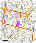
During May 2021, a salvage excavation was conducted on the corner of Jabotinsky and Ibn Gabirol streets, Tel Aviv (Permit No. A-9022; map ref. 179623–30/666153–7; Fig. 1), prior to widening the intersection. The excavation, on behalf of the Israel Antiquities Authority and funded by the Tel Aviv Municipality, was directed by M. Mermelstein (field photography), with the assistance of Y. Amrani and Z. Lotan (administration), I. Jonish (surveying), M. Abu (location map and plan), A. Tamir (metal detector) and Y. Tepper (scientific guidance). Help was also rendered by D. Abu-Salah and D. Barkan from the Central Region of the IAA.
The excavation was located on the northern slope of a hill in the center of Tel Aviv, c. 1.5 km east of the coast and 1.5 km south of the Yarqon River. The Arab village of al-Mas‘udiyya (Summayl) occupied this hill until 1948 (Grossman 2009). Settlement remains from the Hellenistic, Roman, Byzantine and Ottoman periods and British Mandate were exposed in the southwestern part of the hill (Elad 2019 [Fig. 1: A-7779] and see further references therein; Radashkovsky 2020 [Fig. 1: A-8587]; Arbel and Abu-Salah 2024 [Fig. 1: A-8812, A-8953, A-9733]).
In this excavation, a pit hewn into the kurkar bedrock was uncovered.
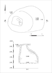
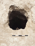
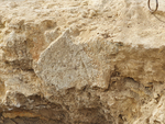
The pit (L101; 1.5 × 2.5 m at the bottom, depth 3.5 m; Fig. 2; 3D model) widened towards the bottom and had a rectangular hewn opening (0.8 × 1.0 m; Fig. 3). The excavation did not reach the base of the pit. Remains of plaster survived on the opening of the pit (Fig. 4).
In the pit, there was a fill of soil and refuse (L100, L103), including pipes, asbestos, plumbing fixtures, glass bottles, a fragment of a Marseille tile and a British Mandate coin. The refuse in the fill and the modern construction overlying the pit indicate that the pit was deliberately filled in a short period during the twentieth century.
It is difficult to determine when the pit was hewn and its function. The pit’s shape and the remains of plaster suggest that it may have been used to collect rainwater when the area was inhabited.
References
Arbel Y. and Abu-Salah D. 2024. Tel Aviv, Arlozorov Street. HA–ESI 136. https://doi.org/10.69704/jhaesi.116.2004.26462
Elad I. 2019. Tel Aviv, Remez Street. HA–ESI 131. https://doi.org/10.69704/jhaesi.116.2004.25559
Grossman D. 2009. The ‘Tel Aviv District’ Settlements in the Ottoman Period—the Village, the Economy and Customs. In E. Ayalon ed. The Secret History of Tel-Aviv: What Happened Here in the Last 20,000 Years? Tel Aviv. Pp. 152–175 (Hebrew).
Radashkovsky I. 2020. Tel Aviv, Arlozorov Street. HA–ESI 132. https://doi.org/10.69704/jhaesi.116.2004.25867
Keywords
Arab village of al-Mas‘udiyya (Summayl), hewn pit, plastered pit, storage pit, Marseille tile, British Mandate
Publication Date
06/09/2026
Link to Excavation Repository
Report Type
Final Report