Ha-Zorea‘, Tel Qiri (A-9723)
Permit/License Number
A-9723
Excavation Report
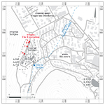
During January 2024, a trial excavation was conducted at Tel Qiri in Kibbutz Ha-Zorea‘ (Permit No. A-9723; map ref. 211032–110/727772–925; Fig. 1), prior to construction of a road bypassing the kibbutz. The excavation, on behalf of the Israel Antiquities Authority and funded by Kibbutz Ha-Zorea‘, was directed by G. Peled, with the assistance of Y. Shmidov (surveying, drafting and photogrammetry), R. Be’eri (scientific guidance), Y. Ya‘aqobi and J. Zilpa (administration), H. Tahan-Rosen (pottery drawing), E. Dalali-Amos and A. Shapiro (map drafting), B. Hana and M. Asakaly from the IAA and workmen from Shefar‘am.
Tel Qiri (Fig. 1; Raban 1999: Site 26) extends on the eastern slope of Tel Qira in Ramat Menashe, overlooking the Jezreel Valley. To its east crosses Naḥal Ha-Shofeṭ, and nearby in the past was ‘Ein Qira spring. The excavation was in the northern part of the Tel where there are chalk outcrops from the Adulam Formation, which slopes sharply from west to east. Excavations on the Tel in 1975–1977 (Ben-Tor and Portugali 1987 [Fig. 1: A-545, A-639, A-712]) uncovered 11 strata, with settlement remains from the Neolithic to the Byzantine period; most of the remains in these excavations were attributed to the Iron Age. Small-scale salvage excavations that took place southeast of the Tel in the 1980s (Meyerhof 1984; 1989 [Fig 1: A-1218, A-1263, A-1281]) uncovered several tombs from the Intermediate Bronze Age. Numerous ancient remains were documented in the vicinity, including settlement remains from a range of periods (Raban 1999: Sites 14, 18, 20, 24, 25, 27, 28, 29, 30).
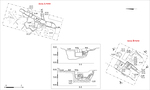
Four excavation areas (A–D; Fig. 2) were opened in the present excavation along a c. 160 m long strip. Excavations found the remains of a building, a quarry and a rock-hewn water channel that probably led to a cave. Pottery dated mostly to the second–third centuries CE was discovered.
Area A
In this area (3.3 × 8.0 m; Figs. 3, 4; 3D model), a quarry for building stones (L25) with two quarrying steps was found. Two walls (W15, W18) that post-date the quarry were uncovered within its boundaries. Wall 15 (length 3.7 m, width 0.5 m, preserved height 0.3 m) was built on the floor of the quarry, oriented approximately north–south. From this wall, only a single foundation course of hewn stones survived. The southern end of the wall adjoined a side of the quarry hewn into the bedrock. This was likely a support wall that was built after the quarry went of use, designed perhaps to confine fills that leveled the surface. Wall 18 (length 1.0 m, width 0.3 m, preserved height 0.3 m) was built from hewn stones in secondary use and fieldstones, and its construction and width differed from W15. Wall 18 abuts Wall 15 at an obtuse angle and presumably post-dates it. A near-sterile accumulation of crumbly and dry grayish soil (L16) was uncovered between the two walls. In contrast, south of W18, a layer of quarrying-debris fill (L28) was exposed; because of time constraints, it was not excavated. Pottery dated predominantly to the Roman period was found in the excavation of this area, but it was not found in sealed contexts.
Area B
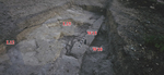
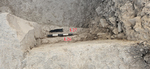
In this area (4.0 × 4.8 m; Figs. 3, 5; 3D model), the remains of a building whose walls were founded on hewn bedrock were discovered. The western wall of the building (length c. 3.3 m, width 1.1 m, preserved height 0.9 m) was partly built of large ashlars (W8) and partly hewn in the chalk bedrock (L24). Two stones were preserved in the northern part of the wall, incorporating a square pillar (W8a; 0.8 × 0.8 m) that protruded c. 0.35 m eastward; the pillar was founded on two rock-hewn steps (L26, L27; Fig. 6). East of W8, a strip of bedrock (L21) was uncovered; it was likely leveled to align with the structure’s floor. Nearby, a layer of grayish crumbly soil (L22; thickness 0.25 m) was laid over the bedrock. The building’s floor was likely originally laid over this area, which was purposely leveled. In this layer, pottery dated to the second–third centuries CE was recovered. After the building went out of use, it was filled with quarrying debris, soil and ash (L5, L13, L14, L17). About 700 pottery sherds were found in this fill; these were also dated to the second–third centuries CE. Given the homogeneity of the ceramic assemblage, it is possible to assume that the building functioned for a short period and went out of use during the third century CE at latest. These finds represent a continuation of Stratum II in Area A1, previously excavated by Ben-Tor (Ben-Tor and Portugali 1987:9–11).
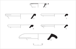
Pottery from Area B. A large homogeneous pottery assemblage dated to the second–third centuries CE was found in the fill-layers of the building and in the layer of grayish soil beneath it. The assemblage is comprised of open vessels, cooking ware, jars and jugs.
The Open Vessels include Kefar Ḥananya Type 1B bowls with two ridges on the rim (Fig. 7:1; Adan-Bayewitz 1993:92–97), also known as Early Galilean Bowls (Ma‘oz 2010); basins with an out-folded rim (Fig. 7:2–5), with parallels at Sepphoris (Balouka 2013: Pl. 8:8–11); and a mortarium with a wide ledge rim slanting downward (Fig. 7:6), with parallels at Sepphoris (Balouka 2013: Pl. 31:6) and Kefar ‘Otnay (Abu-‘Uqsa 2016: Fig. 2:4–6).
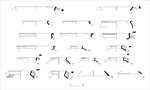
The Cooking Ware include Pans, bowls, casseroles, a krater, pots, and lids were found. The pans (Fig. 8:1, 2) have thick horizontal handles like ones found at Sepphoris (Balouka 2013: Pl. 13:10–11, 29:6–9). The cooking bowls (Fig. 8:3–5) have a short ledge rim, with soot marks observed on some, and they are similar to Kefar Ḥananya Type 3A (Adan-Bayewitz 1993:111–118). The casseroles include wide forms with a ledge rim (Fig. 8:7–9); the rim of Casserole No. 7 is everted, while Casseroles Nos. 8 and 9 are carinated below the rim. There is also a krater, used for cooking, with a rim that curves outward into a hook (Fig. 8:6), with parallels at Sepphoris (Balouka 2013: Pl. 12:1–6). The cooking pots include pots with a flat rim with two grooves (Fig. 8:10–16), similar to Kefar Ḥananya Types 4B and 4C, and a small cooking pot (Fig. 8:17) with a long neck that curves at the joint with the shoulder with parallels at Sepphoris dated to the first century CE (Balouka 2013: Pl. 2:12). The lids include a conical lid for a bowl or open cooking vessel (Fig. 8:18) whose internal surface is not smoothed, with parallels at Kefar ‘Otnay (Abu-‘Uqsa 2016: Fig. 3:14), and a convex lid (Fig. 8:19) with an in-folded rim dated to the third–ninth centuries CE (Magness 1993:215). The latter is the only vessel type in the assemblage whose use continues after the third century CE.
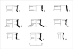
The Jars include an example with an externally thickened rim (Fig. 9:1), manufactured from typical cooking ware fabric; jars with a plain slightly externally thickened rim (Fig. 9:2, 3) and thick walls (thickness 0.8–0.9 cm), with parallels at Sepphoris (Balouka 2013: Pls. 7, 8); and numerous jars (Fig. 9:4–9) have an out-turned rim, usually with a triangular or square thickened cross-section, similar to Sepphoris Type 2–3 storage jars (Balouka 2013:37–38).
A jug (Fig. 9:10) with an outward-opening rim and a narrow upright neck, similar to Kefar Ḥananya Type 6B (Adan-Bayewitz 1993:143–144), was found.
Area C
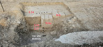
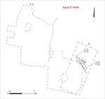
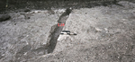
In this area (3 × 8 m; Fig. 10; 3D model), excavations revealed a section of a channel hewn into the chalk bedrock (L10; length 3.2 m, width 0.2–0.4 m, depth 0.2 m; Fig. 11) that slopes from southeast to northwest. Presumably, it drained into a quarried cave (Fig. 10: C1). Although the cave was mapped, it was not excavated. The cave was accessible through a modern breach in its eastern wall. Documentation revealed that the cave had at least two main rectangular chambers (2.6 × 2.6 m, 2.2–3.6 × 4.4 m). The original masons left square support columns (width 0.4–0.6 m) in the rooms.
Area D
In this area (2 × 4 m), a fill of modern sterile soil was cleared down to bedrock (depth 0.2 m). The excavation ended once bedrock was reached.
A quarry for building stones, architectural remains of a building and a rock-hewn water channel were exposed during the excavation. Pottery fragments dating to the second–third centuries CE were found in the fill that covered the building and the floor. This indicates that the building was abandoned during the second or third century CE, and it was probably used only for a short time. The building is a continuation of the Roman settlement remains documented in Area A1 in Ben-Tor’s excavation (Ben-Tor and Portugali 1987:9–11).
References
Adan-Bayewitz D. 1993. Common Pottery in Roman Galilee: A Study of Local Trade. Ramat Gan.
Abu-‘Uqsa H. 2016. Kefar ‘Otnay and Legio HA–ESI 128. https://doi.org/10.69704/jhaesi.116.2004.24904
Balouka M. 2013. Roman Pottery. In E.M Meyers and C.L. Meyers eds. Sepphoris I: The Pottery from Ancient Sepphoris. Winona Lake. Pp.13–57. https://doi.org/10.5325/j.ctv1bxh4tm
Ben-Tor A. and Portugali Y. 1987. Tell Qiri: A Village in the Jezreel Valley; Report of the Archaeological Excavations 1975–1977 (Qedem 24). Jerusalem.
Ma‘oz Z.U. 2010. The Galilean Bowl: A Revised Chronology. Tel Aviv 37:254–257. https://doi.org/10.1179/033443510x12760074470946
Magness J. 1993. Jerusalem Ceramic Chronology: Circa 200–800 CE (JSOT/ASOR Monograph Series 9). Sheffield.
Meyerhof E. 1984. HaZore‘a. ESI 2:45–46.
Meyerhof E. 1989. The Bronze Age Necropolis at Kibbutz Hazorea, Israel (BAR Int. S. 534). Oxford.
Raban A. 1999. Map of Mishmar Ha-‘Emeq (32) (Archaeological Survey of Israel). Jerusalem.
Keywords
Building remains, quarry, hewn water channel, ceramic finds from the second–third centuries CE, settlement from the Roman period
Publication Date
06/09/2026
Link to Excavation Repository
Report Type
Final Report