Ḥorbat Es‘ad (A-9045, A-9098, A-9188, A-9311)
Permit/License Number
A-9045, A-9098, A-9188, A-9311
Excavation Report
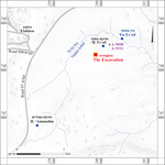
During November 2021–July 2022, trial and salvage excavations were conducted on two hills at Ḥorbat Es‘ad (the western hill—Permit Nos. A-9045, A-9188; map ref. 239950/748280; the eastern hill—Permit Nos. A-9098, A-9311, map ref. 240250/748475; Fig. 1), prior to the installation of the Reverse Water Carrier pipeline. The excavation, on behalf of the Israel Antiquities Authority and funded by Mekorot Water Company, was directed by A. Abu Hamid, with the assistance of R. Assis, A. Najar, A. Shapiro, M. Bekker-Shamir, R. Namouz, K. Hako, A. Shichman, P.R. Tzayk and K. Murad (area supervision), Y. Ya‘aqobi, B. Zidan, Y. Gur, R. Abu Halaf and J. Zilpa (administration), Y. Shmidov, M. Kahan, V. Essman and J.A. Sánchez Streger (surveying), Y. Shmidov, R. Mishayev and M. Kahan (drafting), A. Peretz, Y. Shmidov and A. Kleiner (field photography and drone photography), D. Syon, Y. Drey, R. Sabar and T. Badichi (metal detector), H. Tahan-Rosen (architectural elements drawing), P. Gendelman, Y. Alexandre, A. Berlin, R. Sabar, A. Gilboa, G. Shalvi and M. Osband (pottery), O. Barzilai and A. Yaroshevich (flint), D. Gazit (studio photography), D. Ben-Ami and R. Be’eri (scientific guidance and consultancy), S. Freirich (conservation), E. Ambar-Armon (education center director), R. Assis (mapping of cisterns and building remains on the eastern hill), O. Zingboym and H. Mamalya (IAA Eastern Galilee and Golan District) and workers from Kafr Manda, Kabul, Sha‘ab and Bir el-Maksur.
The site extends over two hills (western and eastern), south of Naḥal Arbel, east of Bet Neṭofa Valley and southwest of ‘En Es‘ad. The western hill is characterized by basalt bedrock, while the eastern hill is characterized by chalk bedrock, covered by a layer of nari. In British Mandate maps, the site is designated as Khirbat es-Sa‘d, and a nearby spring bares the same name. Previous surveys at the site documented architectural remains from the Roman and Byzantine periods and yielded pottery sherds from the Iron Age–Byzantine periods. This indicates that the site was primarily occupied during the Early Roman period, and it was abandoned in the late third–early fourth centuries CE (Gal 1990:54; Leibner 2004:141–144; 2009:201–203). In 2020, a development survey was conducted at the site by R. Assis on behalf of the IAA (License No. S-1039/2020).
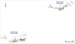
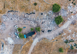
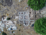
The excavation was conducted on both hills, and 168 squares were opened in eight areas (A–H; 4,200 sq m; Fig. 2). The excavation on the western hill was located on the southern fringe of the site (Areas A–D), and it uncovered settlement remains from the Iron Age I (Stratum IV) and Iron Age II (Stratum III), an agricultural estate from the late Hellenistic period and the Hasmonean period (Stratum II) and tombs likely dating to the Ottoman period (Stratum I). The excavation on the eastern hill was conducted on its northern edge (Areas E–H), and it uncovered four strata from the Roman (Strata IV–II) and Fatimid (ninth century CE; Stratum I) periods. On both hills, excavations uncovered a few Lower Paleolithic and Pottery Neolithic flint tools, which probably originated from a nearby site that was not identified yet, as well as pottery from the Late Bronze Age, the Iron Age IIC and the Persian and Roman–Ottoman periods.
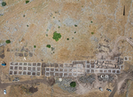
The Western Hill (Areas A–D; Fig. 3)
Area A
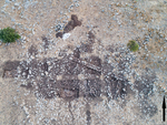
The western wall and part of the northern wall of a broad building were visible on the hilltop surface. The excavation exposed the southern wall of the building (length 15 m, width 0.7 m; Fig. 4). South of this wall, there was a layer of collapsed basalt stones that originated from the building’s walls. No datable finds were discovered.
Area B (Fig. 5)
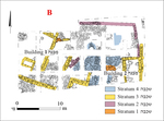
Four strata were uncovered, and they were dated to the Iron Age I (Stratum IV), the Iron Age II (Stratum III) and the Hellenistic (Stratum II) and Ottoman (Stratum I) periods.
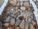
Stratum IV. Remains of a wall, a foundation trench, an installation and floors that were dated by the pottery to the Iron Age I (twelfth–first half of the tenth centuries BCE) were uncovered. The wall was built of one row of large basalt stones on the bedrock, with a floor of small stones abutting it. A circular installation built sunk into the ground (Fig. 6) was found west of the wall. A foundation trench of another wall, whose stones were robbed probably for subsequent reuse, was found in the center of the area. The wall and foundation trench indicate that the buildings in Stratum IV were oriented northeast–southwest.
Stratum III. Two partially preserved buildings (1, 2) were uncovered; they were not fully exposed. Of Building 1, four rooms were uncovered, and of Building 2, two rooms were uncovered. The external walls of the buildings were wide and constructed of two rows of large stones, while the internal walls were constructed of a single row of stones. Rectangular or square installations were built in some of the rooms (Fig. 7). The stratum was attributed to the Iron Age IIa (mid-tenth–late ninth centuries BCE) based on the pottery.
Stratum II. This stratum was severely damaged by recent agricultural activity. Meager remains of walls and segments of a stone floor survived. Because of the distance between the walls, it was impossible to determine if they belong to one building. This stratum contained pottery dating to the Iron Age IIA–IIC (tenth–eighth centuries BCE), but was it was dated based on its later pottery to the late Hellenistic period (second century BCE). Among the finds from this stratum is a jar handle bearing a stamped impression of a scorpion that is dated to the Iron Age I–II.
Stratum I. Two tombs that were dug into Stratum III were found. One tomb contained a child’s skeleton. It was oriented east–west, with the head to the west and facing south. This seems to be an Ottoman-period (seventeenth century CE) Muslim burial. The second tomb was not excavated.
Areas C and D (Fig. 8)
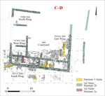
Two occupation strata were uncovered and dated to the Iron Age II (Stratum III) and the Hellenistic period (Stratum II); two building phases were identified in Stratum II (B and A).
Stratum III. Remains of a wall constructed of a single row of large basalt stones, oriented north–south or east–west, were uncovered. Sections of smoothed basalt floors were found. Next to one wall, a cluster of ten globular clay loom weights, typical of the Iron Age, was found. The stratum was dated based on pottery to the Iron Age IIa. Among the noteworthy finds uncovered in this stratum are two zoomorphic figurines.
Stratum IIB. Remains of an agricultural estate (24 × 26 m), were exposed, including four wings of rooms built around an inner courtyard. The southern wing was fully exposed, while the northern, eastern and western wings were only partially excavated. The estate was founded partly on bedrock and partly on the remains of Stratum III. The perimeter walls were massive (width 0.8–0.9 m) and built mostly of large roughly hewn stones. The partition walls between the rooms were narrower. The entrance to most rooms faced the courtyard. The rooms were found filled with collapsed stones piled on the floors up to the preserved height of the walls. This phase was dated by the pottery and coins to the second century BCE.
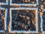
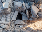
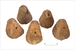
The southern wing (3 × 26 m) was comprised of two units: western and eastern. The western unit contained three rooms; an entrance connecting this unit to the western wing was exposed in its northern wall. The unit’s floor was partly made of tamped earth, into which an installation paved with smooth basalt stones was set. In the eastern room, there was a paved section that contained an entrance to a subterranean storeroom (Fig. 9) with basalt walls. A built shelf was also exposed in this room, upon which a concentration of approximately 80 clay loom weights, characteristic of the Hellenistic period, was discovered (Fig. 10). Pounding tools, storage vessels and iron tools were uncovered on the shelf and the room’s floor. These likely remained in situ since the building was abandoned in the mid-second century BCE. In the central room, three entranceways with large basalt doorjambs were uncovered. Two of the entrances led to the western and eastern rooms, and the third led to a central courtyard. This room may have been used for various crafts and cooking. The eastern unit was comprised of a single rectangular room, with an entrance in the northern wall, bordering the central courtyard. The floor of the room was made of tamped earth, upon which the remains of a rectangular installation were discovered.
The central courtyard of the estate was square (13.5 × 13.5 m), though only its southern part was exposed. A bedding made of fieldstones was found in the courtyard. Adjacent to the southern wing’s wall, a circular installation built of fieldstones was uncovered.
Stratum IIA. Minor modifications were made to the estate. The entranceway that connected the western unit of the southern wing to the western wing was blocked. In the central room of the western unit of the southern wing, a new wall divided the room into two smaller rooms. One was likely used for storage, while an in situ cooking pot indicates that the other was used for cooking. The subterranean storeroom discovered in the eastern part of the western unit in Stratum IIB remained in use during this phase. The phase was dated to the late second–first half of the first centuries BCE.
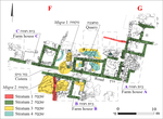
The Eastern Hill (Areas E–H; Figs. 11, 12)
Stratum IV. An ashlar quarry was uncovered. The severance channels (width 0.1–0.5 m) that were identified indicate that medium–large stones were quarried. The stratum was dated by the pottery to the mid-first century BCE.
Stratum III. Remains of two miqva’ot (1, 2), a subterranean space, a cistern and a winepress, all hewn into the chalk bedrock, were uncovered.
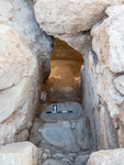
Miqveh 1 (Fig. 13) was hewn in a north–south orientation; its entrance was to the south. The miqveh was composed of an anteroom (0.6 × 1.4 m) with five–six steps descending northward to a round subterranean chamber with an immersion pool (0.7 × 3.4 m). The top part of the eastern side of the anteroom was built of limestone. Three steps were hewn in the immersion pool. The miqveh was coated with a thick layer of gray hydraulic plaster.
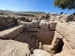
Miqveh 2 (Fig. 14) was hewn in an east–west orientation. The miqveh was comprised of an impressive corridor with five–six steps descending westward to a subterranean chamber with an immersion pool; the chamber was partly excavated. Four steps with traces of gray hydraulic plaster were found in the immersion pool.
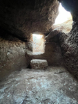
A hewn subterranean space (2.1 × 3.5 m, height 1 m; Fig. 15) was discovered c. 3.5 m east of Miqveh 2. At the entrance to the space, a hewn step was uncovered. Unlike the miqveh, the walls of the space were not plastered, suggesting the space had a different function and was used perhaps as a storage facility.
A hewn cistern was uncovered next to the steps of Miqveh 1. Traces of hydraulic plaster were found on the walls. Two phases were identified in the cistern. In the early phase, it may have functioned as a reservoir for Miqveh 1, and in the later phase, a wall was built next to its opening. The cistern was only partially exposed due to safety concerns.
A hewn winepress (Fig. 16; not illustrated in Fig. 12) was uncovered on the northwestern edge of Area H. It was comprised of a square treading floor (3.7 × 3.7 m, depth 0.54 m) and a collecting vat (1.6 × 1.6 m, depth 2.18 m). The shared wall of the treading floor and the vat was low, allowing for liquid to flow from the treading floor to the vat. Two hewn niches were visible in the eastern wall of the vat.
Stratum II. Remains of three farmhouses (A–C) and a road (length c. 30 m, width c. 2 m) that connected the buildings to the agricultural area were uncovered. The boundary walls of the road were founded on bedrock, and several entrances leading to the farmhouses were incorporated into them. Collapsed building stones covered the road, and among the stones, there was Roman pottery (mid-second century CE).
Farmhouse A was a large architectural complex. Its entrance (width 1.1 m) was set in its southern side. A step descended from the threshold into a corridor that led to a courtyard paved with smoothed basalt slabs in various sizes (Fig. 17). A stone bench was built along the western side of the corridor and the courtyard. A cistern was hewn beneath the courtyard, and its entrance was located within the corridor and made from a limestone slab (diam. 0.6 m). A storage cell and an installation built from basalt and limestone were exposed in the courtyard. A staircase along the western wall of the courtyard ascended westward from the courtyard to a wing that included at least three rooms and an inner courtyard to their north, all founded on bedrock. Segments of basalt-slab paving were found in some of the rooms. Beneath the floor of one room, a hoard of silver coins was found; it may have been wrapped with a textile that did not survive. The walls of the central room in this wing were built of hewn limestones, doorjambs and thresholds in secondary use, originating from Stratum III. The pottery assemblage from the floor of the rooms and the collapsed stone heaps were dated to the second–third centuries CE. Miqveh 1 was incorporated into the complex and functioned as a water reservoir.
Farmhouse B, which was partly excavated, included several rooms built on two bedrock terraces. Patches of floors, storage installations and work surfaces were preserved in the rooms. The subterranean space from Stratum III remained in use within this complex, but its entrance was narrowed using large limestones that rendered its original hewn step obsolete. Millstones were incorporated in secondary use into the walls of the chamber. At the same time, the entrance to Miqveh 2 was blocked with a fill of soil and stones.
Farmhouse C was also partially excavated. Excavations exposed several rooms that opened into an inner courtyard to their north.
Stratum I. Two wall segments were found. The first wall segment was carelessly built from a single course of basalt and limestone, with Fatimid-period (ninth century CE) pottery sherds found in its vicinity. The second wall segment was founded on the bedrock terrace within the area of Farmhouse B. These meager remains indicate that there was a temporary presence at the site after the settlement was abandoned.
Conclusion
Excavations revealed remains of an Iron Age I–II rural settlement that was probably located near an ancient road along Naḥal Arbel (Leibner 2009:14–17). The economy was based predominantly on agriculture and pastoralism, including the use of secondary products as evidenced by the loom weights. The later settlements that were discovered at Ḥorbat Es‘ad may have also been associated with the road near Naḥal Arbel.
During the late Hellenistic period and the Hasmonean period, agricultural estates were rare in the Galilee. The agricultural estate identified in this excavation was constructed with a layout typical of rural buildings during the Hellenistic period. The good preservation of the building and the utilitarian artifacts that were found illuminate the nature of the settlement and the lifestyle of the population in the Galilee during the Hellenistic period and after the Hasmonean Kingdom expanded into the Galilee during the second half of the second century BCE.
The settlement was probably relocated from the western hill to the eastern hill a few years after the Hasmonean conquest. The first settlement on the eastern hill occurred during the second half of the first century BCE when a Jewish settlement was established here (Leibner 2009:201–203). During the second century CE and after the Great Revolt, the ancient settlements in the Galilee expanded (Leibner 2009:345–351). The finds of these excavations suggest that a similar process also occurred at Ḥorbat Es‘ad. The miqva’ot went out of use, and the new buildings constructed over them indicate that the settlement expanded eastward. The settlement was abandoned in the early fourth century CE, and in the ninth century CE, a renewed presence was identified.
References
Gal Z. 1990. Lower Galilee: Historical Geography in the Biblical Period. Tel Aviv (Hebrew).
Leibner U. 2004. History of settlement in the Eastern Galilee during the Hellenistic, Roman and Byzantine periods. Ph.D diss., Bar-Ilan. Ramat Gan.
Leibner U. 2009. Settlement and History in Hellenistic, Roman and Byzantine Galilee: An Archaeological Survey of the Eastern Galilee (Texts and Studies in Ancient Judaism 127). Tübingen. https://doi.org/10.1628/978-3-16-151460-9
Keywords
‘En Es‘ad, Iron age, Helenistic period, Hasmonean period, Roman period, Fatimid period, Ottoman period, settlement remains, agricultural estate, miqva’ot, tombs, farmhouses
Publication Date
06/09/2026
Report Type
Preliminary Report