Ẓippori (Southwest) (A-9677)
Permit/License Number
A-9677
Excavation Report
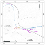
During October 2023, a trial excavation was conducted southwest of Moshav Ẓippori (Permit No. A-9677; map ref. 224660/737925; Fig. 1), prior to constructing a bridge over Naḥal Ẓippori. The excavation, on behalf of the Israel Antiquities Authority, was directed by G. Peled, with the assistance of Y. Ya‘aqobi and J. Zilpa (administration), R. Be’eri (scientific guidance), M. Kahan (plans and drone photography), A. Efron (GPS), A. Shapiro (GIS), B. Hana and M. Masarwa from the IAA and workmen from Kafr Manda.
The excavation area (Fig. 1) was located c. 1.25 km west of ‘En Ẓippori and c. 1.7 km southeast of Ḥorbat Shimshit. The site extends across a broad valley that is traversed by Naḥal Ẓippori and collects streams from the surrounding hills. The streambed adjacent to the excavation area, passing between Giv‘at Rabbi and Giv‘at Kusbar, provides a relatively convenient route southward from Naḥal Ẓippori toward the village of ‘Illuṭ. The area was initially surveyed in the late nineteenth century CE (Guérin 1987:253–254). Since 2009, numerous excavations were conducted in the area following the development of Highway 79. These excavations yielded remains from a range of periods, including the prehistoric (Feig 2013; [Fig. 1: A-6333]; Abu Zedan 2014 [Fig. 1: A-6383]; Mokary 2020 [Fig. 1: A-7517]; Shatil 2020 [Fig. 1: A-7912]).
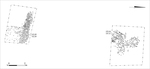
In the current excavation, two excavation squares were opened on both banks of Naḥal Ẓippori (Fig. 2): a southern (12 sq m) one and a northern (12.25 sq m) one. A surface of stones, meager remains of a wall and a mixed pottery assemblage were discovered.
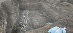
The Southern Square (Fig. 3). An elongated surface of limestone fieldstones, oriented east–west (L103; at least 1 × 4 m, c. 0.3 m thick), was found in this square. Adjacent to the southern end of the stone surface, washed and worn pottery sherds that could not be dated and a few fieldstones were found. Due to the limited scope of the excavation, the full dimensions of the surface could not be exposed, and its function could not be determined; however, it may have served as an agricultural work surface or a field road.
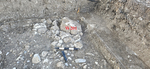
The Northern Square. A thick modern soil fill was exposed in this square, yielding pottery sherds (97 sherds, 90 of which body fragments) and flint items (not drawn) that were washed down the stream and were dated from the Paleolithic period to the twentieth century CE. In the southwestern part of the square, there were remains of a wall (W201; preserved length 1.2 m, width 0.6 m; Fig. 4), oriented north–south. The wall was cut by mechanical equipment.
References
Abu Zedan F. 2014. Ẕippori (Southwest). HA–ESI 126. https://doi.org/10.69704/jhaesi.116.2004.8483
Guérin V. 1887. Geographical, Historical, and Archeological Description of the Land of Israel 7: Galilee (Part II) (H. Ben-Ambram transl.). Jerusalem (Hebrew).
Mokary A. 2020. ‘En Ẕippori (West). HA–ESI 132. https://doi.org/10.69704/jhaesi.116.2004.25693
Feig N. 2013. Naẖal Ẕippori, Highway 79. HA–ESI 125. https://doi.org/10.69704/jhaesi.116.2004.2259
Shatil N. 2020. ‘En Ẕippori. HA–ESI 132. https://doi.org/10.69704/jhaesi.116.2004.25715
Keywords
Naḥal Zippori, Giv‘at Rabbi, Giv‘at Kusbar, surface of stones, wall remains, agricultural work surface, field road, ceramic finds
Publication Date
07/09/2026
Link to Excavation Repository
Report Type
Final Report