
Kafr Bara (A-9555)
Permit/License Number
A-9555
Excavation Report
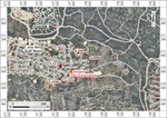
During March 2023, a trial excavation was conducted on a-Rawda Street, Kafr Bara (Permit No. A-9555; map ref. 197797–803/670765–771; Fig. 1), following damage to antiquities during infrastructure work for a new neighborhood. The excavation, on behalf of the Israel Antiquities Authority and financed by I.P.D Engineers Ltd., was directed by D. Masarwa, with the assistance of Y. Amrani (administration), H. Hamer and O. Amichay (survey of underground spaces), S. Emmanuilov (photogrammetry and photography), S. Krispin (metal detector) A. Keinan (health and safety), Y. Tepper (scientific guidance), T. Harpak (finds processing), H. Torgë (pottery), M. Shuiskaya (pottery drawing), R. Kool (numismatics), M. Viezel and A. ‘Azab from the IAA and Palestinian workmen from Nablus.
The Kefar Sava Map Survey recorded a large tel near the village, including building remains, a fortification wall, numerous installations, tombs and finds from a range of periods (Beit-Arieh and Ayalon 2012: Site 158 and see therein for context and references). Additional remains and finds were documented within the village and its surroundings (Beit-Arieh and Ayalon 2012: Sites 149–190). Previous excavations near Kafr Bara uncovered settlement remains from the Roman, Byzantine, Early Islamic and Mamluk periods (Arbel 1999 [Fig. 1: A-2638]; Sari 2000 [Fig. 1: A-2273]; Abu Fana 2003 [Fig. 1: A-3208]; Abu Fana 2010 [Fig. 1: A-3526]). A trial excavation was conducted in 2019 prior to expanding the village to the east and southeast. It exposed large hewn caves that were used during the Neolithic and Chalcolithic periods and the Early Bronze Age as well as agricultural installations and hewn tombs from the Roman, Byzantine, Early Islamic and Mamluk periods (Tendler and van den Brink 2022; Tendler and van den Brink 2024 [Fig. 1: A-8596]).
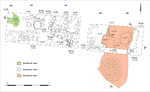
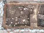
In the current excavation, five excavation squares were opened in a row (D2–D6; Figs. 2, 3; 3D model), and remains attributed to two strata (I, II) were uncovered. A quarry and a hewn underground space, which probably led to a reservoir or cistern, were attributed to the early Stratum II. An Early Islamic building, with remains from two construction phases, was built above these remains in the later Stratum I. All remains were damaged by drainage and electricity infrastructure work. The stratigraphic relationship between the remains is not clear due to the constraints of the excavation.
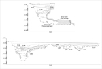
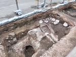
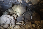
Stratum II. Following damage during infrastructure work, the entrance of an underground space hewn into the bedrock (Fig. 4) was uncovered in the eastern part of the excavation (Squares D5 and D6). The full extent of the underground space could not be ascertained since it extends below the road, south of the excavation. The space was documented but not excavated because of safety concerns due to the extensive accumulation of soil and alluvium inside it, so its date is unclear. The northern, eastern and western walls are plastered; the southern wall was not identified due to the accumulation of soil and alluvium. In the center of the underground space, there were large stones and boulders (Fig. 5) that blocked a shaft, which probably served as the entrance to a reservoir or cistern about 3 m south of the excavation.
Part of a quarry (L101; see Fig. 4), which extends north beyond the excavation boundaries, was exposed in a bedrock outcrop above the underground space. Three quarrying steps with hewing marks and severance channels (width 0.11 m) were uncovered. Quarrying marks of stones that were severed from the bedrock (0.30 × 0.65 × 1.30 m) were uncovered at the bottom of the quarry.
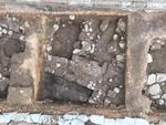
Stratum I. Remains of a large building that extends outside the excavation boundaries to the north, south and west were exposed in all the excavation squares. The building remains comprised segments of walls (W103, W108, W110, W114, W121), which delineated two rooms (L109, L115; Fig. 6) and two courtyards (L102, L111). A late construction phase was also identified in Courtyard 111. Excavations exposed a floor of small fieldstones and gray mortar in Room 115 and a crushed lime floor in Room 109. Heaps of collapsed stones (L107) from the building were found on the floor of Room 115. Evidence of burning was found on the floor of Room 109. Walls 108, 114 and 121, which delineate the two rooms, were built of semi-dressed stones; Wall 114 was built of a single row of stones, while Walls 108 and 121 were built of two rows of stones with a core of small fieldstones.
Courtyards 102 and 111 were uncovered to the west and east of the rooms. In Courtyard 102, a floor of medium and small-sized fieldstones, bounded on the east by W103, was uncovered; it was severely damaged by the infrastructure work, and only a segment in the western part survived. The floor was built on crushed lime bedding (L105), which was laid on a fill of small fieldstones mixed with numerous pottery sherds (L100); the fill was used to level the surface over the bedrock. Wall 103 was cut during the infrastructure work, and only two courses of semi-dressed limestones and small fieldstones bonded with gray mortar were preserved in the northern and southern sections of Square D6. Two floors (L111, L113), one on top of the other, were identified in Courtyard 111 (Fig. 7), abutting W110, which bound the courtyard on the north. Floor 111 was constructed of medium and small fieldstones and attributed to the early phase, while Floor 113 was of gray plaster and attributed to the late phase. Wall 110 was built of semi-dressed limestones, and it extends beyond the boundaries of the excavation. A hewn and plastered cistern with a round opening (L112; diam. 1 m) was found in Courtyard 111; it was not excavated because of the excavation constraints. The opening was initially incorporated into the earlier Floor 111, and eventually it was raised by a ring of fieldstones and incorporated into the later Floor 113.
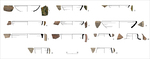
Pottery sherds from the Early Islamic period (eighth–eleventh centuries CE) were found on the floor of Room 115, under the floors of Rooms 109 and 115 and Floor 113 (L116–L118), in Courtyard 102 and in the collapsed stone heap (L107). The pottery includes two Common Glazed bowls (Fig. 8:1, 2), a bowl with ledge-rim (Fig. 8:3), a glazed bowl (Fig. 8:4), a glazed bowl imported from Beirut (Fig. 8:5), simple bowls (Fig. 8:6, 7), a deep bowl (Fig. 8:8), jars (Fig. 8:9, 10) and jugs (Fig. 8:11, 12).
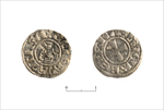
A silver-billon denier (Fig. 9), which was minted at the time of the Crusader King Amaury I (1163–1174 CE) or his heirs (IAA 189167), was uncovered in the collapsed stone heap (L107). The coin was minted before the Battle of Hattin and the fall of the Kingdom of Jerusalem, and it is one of the most common coin types in the kingdom until its fall.
Part of a stone quarry and a hewn and plastered underground space, which probably led to a reservoir or a cistern that was blocked at some point with large stones and rocks, were attributed to Stratum II. Remains of an Early Islamic building were attributed to Stratum I and join previously identified Early Islamic settlement remains in the vicinity (Arbel 1999; Abu Fana 2010). The Crusader-period coin in a heap of collapsed building stones indicates that there was also later activity in the area. The cisterns and stone quarry that were uncovered in the excavation are probably associated with similar remains that were previously uncovered nearby (Tendler and van den Brink 2024) and formed part of the agricultural hinterland of the ancient settlement that existed throughout multiple periods.
References
Abu Fana M. 2003. Kafr Bara. HA-ESI 115:73*.
Abu Fana M. 2010. Kafr Bara. HA–ESI 122. https://doi.org/10.69704/jhaesi.116.2004.1378
Arbel Y. 1999. Kafr Bara. HA–ESI 109:50*.
Beit-Arieh I. and Ayalon E. 2012. Map of Kefar Sava – 77 (Archaeological Survey of Israel).
Sari K. 2000. Kafr Bara. ESI 20:44*.
Tendler A.S. and van den Brink E.C.M. 2022. A Pottery Neolithic Cave near Kafr Bara along Naḥal Qanah, Central Israel. IEJ 72.1:1–13.
Tendler A.S. and van den Brink E.C.M. 2024. Kafr Bara. HA–ESI 136. https://doi.org/10.69704/jhaesi.116.2004.26444
Keywords
quarry, hewn underground space, reservoir, water cistern, building remains, Early Islamic period, billon denier, Crusader period, agricultural hinterland
Publication Date
07/10/2026
Link to Excavation Repository
Report Type
Final Report