Khirbat Maraḥ el-Jawami‘a and Khirbat Gharib, Survey (5-2-2020)
Permit/License Number
5-2-2020
Excavation Report
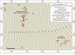
During July 2022, a survey was conducted in Khirbat Maraḥ el-Jawami‘a and Khirbat Gharib in the northern Hebron Mountains (Archaeological Officer License No. 5-2-2020; map ref. 214/621; Fig. 1). The survey, on behalf of and financed by the Institute of Archaeology of Bar-Ilan University, was directed by D. Raviv (field photography, surveying and drafting and coin identification), J. McClellan (surveying and drafting) and A. Faust, with the assistance of Y. Rudman (pottery drawing), M. Lavi (coin cleaning) and T. Rogovsky (studio photography). Students from the Department of Land of Israel Studies and Archaeology at Bar-Ilan University and tour guides from the Kefar ‘Eẓion Field School took part in the survey.
The areas of Khirbat Maraḥ el-Jawami‘a (map ref. 214247/621778) and Khirbat Gharib (map ref. 214832/621242), located about 700 m apart, are cultivated nowadays, but traces of the ancient remains are visible, including building stones incorporated into retaining walls of agricultural terraces and entrances to subterranean spaces hewn into the bedrock. The survey identified and mapped remains of buildings and installations, some of them subterranean, and collected surface finds. In addition, the plan of Khirbat Maraḥ el-Jawami‘a was updated, a plan of Khirbat Gharib was prepared and a hiding complex, which was previously uncovered in Khirbat Gharib, was mapped. The present survey joins previous surveys conducted in both sites and adds information to the study of their history and the region. The survey demonstrates the importance of exploring and documenting subterranean spaces in archaeological surveys, particularly in areas where the settlement remains are barely visible on the surface because of intensive agricultural activity. The following describes the installations that were not previously published or for which the present survey added new information.
Khirbat Maraḥ el-Jawami‘a
Remains of a rural site are visible on the crest of a gentle spur, which forms part of a ridge traversed by the national watershed divide. A. Ofer (1993:93), who surveyed the region during the Judean Mountains Survey, reported two antiquity focal points: (a) Khirbat Maraḥ el-Jawami‘a (Ofer 1993: Site 321)—a ruin of 12 dunams, in which pottery from the Iron Age II–Late Islamic periods was collected; (b) and Jawami‘a (Nabi Danyal), south (Ofer 1993: Site 322)—a nameless ruin about 300 m south of Khirbat Maraḥ el-Jawami‘a, in which there is a cluster of rock-hewn tombs, pottery from the Iron Age II and the Persian, Byzantine and Late Islamic periods, as well as pottery sherds from the Iron Age II with ‘lmlk’ and rosette stamps. These two focal points likely represent a single settlement site, with its core at Focal Point A and its margins at Focal Point B. In 2001, D. Amit and I. Yezerski (Amit and Yezerski 2001) documented rock-hewn installations on the eastern slope of the spur, including a dozen burial caves and a winepress dated to the Iron Age II as well as an oil press cave, a columbaria, a winepress, two miqva’ot and cisterns dated to the Roman and Byzantine periods. Amit (1996:22) also noted a ‘yršlm’ seal impression at the site, a find characteristic of settlements within the administrative boundaries of Judah during the Hasmonean period (on dating these stamps, see Bocher and Lipschits 2013). Later, S. Batz and Y. Peleg (Batz 2007; Peleg 2009a) recorded on the northwestern slope of the spur two shelf tombs. These tombs contained ossuaries with broken lids and pottery sherds dated to the Iron Age IIB and the Early Roman period. Approximately 500 m north of the site, C. Cohen (2016:35) documented a miqveh hewn into the bedrock; it may have served the inhabitants of Maraḥ el-Jawami‘a during the late Second Temple period. Based on the Iron Age II finds, Amit and Yezerski (2001:172) proposed Khirbat Maraḥ el-Jawami‘a was one of the cities in the Bethlehem district mentioned in the Septuagint version of Joshua 15. In the British Survey records, the site is called Khirbat el-Kussis (Conder and Kitchener 1883:118), and based on this name, B.N. Rosenfeld (1991:215–217) suggested this was Bet Meqoshesh, the home of the Caiaphas/Qayafa priestly family during the Second Temple period.
Twenty-seven find spots were recorded in the present survey (Appendix — The Survey Data: Table 1), some newly discovered, including seven rock-hewn burial caves (Nos. 12, 15, 19–21, 24, 25), cluster of ashlar blocks (No. 16), two rock-hewn installations (Nos. 5, 6) and a cluster of hewn cupmarks (No. 14). In addition, winepresses, an oil press cave, a cistern and 12 burial caves were previously documented by Amit and Yezerski (2001). Below is a brief description of only the newly discovered remains. The finds, including pottery vessels and a single coin, will also be described.
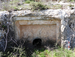
Burial Cave 12 (Fig. 2). The cave has a stepped façade and a square burial chamber (2.3 × 2.8 m, height c. 1.4 m). In the center of the burial chamber, there is a standing pit surrounded by three shelves (average width 0.9 m). In the eastern corner of the burial chamber, there is a round pit (diam. 0.6 m, depth 0.5 m) in which bones were collected.
Burial Caves 15, 19 and 20. The entrances to these caves were blocked, so the caves were not recorded.
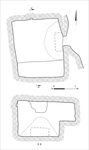
Burial Cave 21 (Fig. 3). The cave was recently breached by antiquities robbers, and its façade was lost. The cave contains a rectangular burial chamber (2.3 × 2.6 m, height 1.6 m), and a shelf was hewn in its southern part (width 0.75 m).
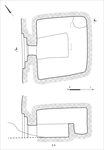
Burial Caves 24 and 25 (Figs. 4, 5). These are adjoining caves with a shared courtyard. Each cave has a stepped façade and a burial chamber. In the center of Burial Cave 24 (2.8 × 3.1 m, height c. 1.5 m), a standing pit was hewn and surrounded by three shelves (0.8–0.9 × 1.9–2.5 m), each with a low parapet and a rectangular stone pillow, used presumably to rest the head of the deceased. A pit for collecting bones was hewn in the northeastern corner of the burial chamber. In the center of the burial chamber in Cave 25 (2.8 × 3.2 m, height c. 1.4 m), a standing pit surrounded by three wide shelves (width 1.0–1.2 m) was hewn. A loculus (0.4 × 0.5 m, height 0.7 m) was hewn in the southern wall of the room, and it was apparently not completed.
The burial chambers of the two caves share a narrow wall (width c. 0.1 m), which was likely breached in antiquity. Based on the architecture, and the parapets around the shelves in Cave 24 in particular, the burial caves are likely dated to Iron Age II.
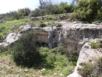
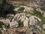
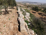
Ashlar Blocks 16. At the top of the slope, there is a cluster of large ashlar blocks (0.3–0.4 × 0.4–0.6 × 0.6–0.7 m; Fig. 6), which likely represent a building that was damaged by intensive agricultural work; walls were not identified. Several of the blocks exhibit marginal drafting and prominent bosses. Some of the blocks were incorporated into the retaining walls of agricultural terraces (Fig. 7).
Rock-Hewn Installations 5 and 6. Two shallow basins were exposed side by side, filled with alluvium. Basin 5 is circular (diam. c. 0.8 m), while Basin 6 is rectangular (0.5 × 1.2 m); their depth is unknown.
Cupmarks Cluster 14. Three conical cupmarks (average diam. 0.2 m, average depth 0.15 m) were uncovered.
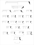
Finds. Pottery fragments and a single coin were collected from the surface in three areas (Appendix — The Survey Data: Table 2): the eastern slope of the spur (Basket 1), the northern slope of the spur (Basket 2) and the top of the spur (Basket 3). The pottery assemblage contains 66 identifiable fragments, mostly rims, including a krater dated to the Iron Age II (Fig. 8:1); a fish-plate (not illustrated), a mortarium (Fig. 8:2), a krater (Fig. 8:3) and jars (Fig. 8:4–13) dated to the Persian–Early Hellenistic periods; jars (Fig. 8:14–16) dated to the late Hellenistic period; jars (Fig. 8:17–19) dated to the Early Roman period; a jar (Fig. 8:20) dated to the Late Roman period; and a jar (Fig. 8:21) dated to the Byzantine–Early Islamic periods. Some of the vessels from the Persian and Hellenistic periods that were identified as jars could also be jugs or kraters. All the vessels were locally manufactured, excluding the mortarium (see Fig. 8:2), which may have been imported. The predominant periods represented are the early and late Hellenistic (Hasmonean) periods, contrasting with the previous survey, which found primarily pottery dated to the Iron Age. Significant settlement activity during the Hellenistic period is also evident at other sites in the region, such as Ḥorbat Bet Zekharya (Raviv 2025).
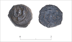
The coin (diam. 14–16 mm; 2.91 gr; Fig. 9) is a bronze pruta dated to the Hasmonean period (129–85 BCE). One side depicts a pair of cornucopias with a pomegranate between the horns, while the other bears an inscription within a wreath; the other side is heavily worn.
Khirbat Gharib
Remains of a rural site are visible by a road (present day Road 60), which connects Jerusalem to Hebron and was first laid during the Ottoman period (Amit 1977). The remains of the site extend on the slope of a gentle spur. A prior emergency survey described the site as a ruin that was destroyed by agricultural cultivation and collected Byzantine pottery (Kochavi 1972:42, Site 34). A. Ofer (1993: Appendix 2/A, p. 12) discovered pottery sherds from the Iron Age II–Byzantine period. D. Amit reported a miqveh, architectural remains, rock-hewn installations, a short hiding complex and cisterns (Amit 1997:23, Fig. 16). M. Marcus and D. Amit noted Roman pottery and coins at the site (Marcus and Amit 1989:66, Site 42). Y. Peleg recorded a shelf tomb and miqveh at the site (Peleg 2009b); this is the same miqveh that was recorded previously by Amit. B. Zissu (2001:114) described two parts of a hiding complex, one (the western wing, see below) including a tunnel (length 9 m) along which a hiding room was hewn, and the other (the eastern wing, see below) including a cistern with a tunnel hewn into its wall.
Thirteen find spots were recorded in the present survey (Appendix — The Survey Data: Table 3), including hiding complexes (Nos. 1, 13), cisterns (Nos. 2, 4–6, 11), burial and storage caves (Nos. 8–10, a miqveh (No. 12), a columbarium (No. 3) and a cupmark (No. 7). The two hiding complexes, located about 20 m apart, are probably two wings of a single hiding complex that was previously recorded (Amit 1997; Zissu 2001)—the eastern (No. 1) and western (No. 13). Hiding Complex 1 will be described below. The miqveh was also previously described (Amit 1997; Peleg 2009b) and will not be described further here.
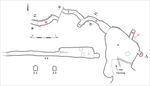
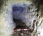
Hiding Complex 1 (Fig. 10). A large cave (A; 8 × 11 m, height 2.0–2.5 m) with hewn loculi in its walls (B and C) and two hiding tunnels (D and E/F) was recorded. The entrance to the cave is bounded on the east with a built stone wall, and it leads to a stepped antechamber reminiscent of entrance to a dwelling cave. A square shaft (1 × 1 m), which may have served as an entrance at a late phase, was hewn in the cave-ceiling. The shaft is similar to the opening of a cistern, so it is therefore presumably the part of the hiding complex that Zissu described in error as a cistern (above). Loculi B and C (length 0.6–1.0 m, width 0.6, height c. 1 m) were hewn into the walls and floor of the cave. Their shape and size suggest that they were unfinished tunnels. Tunnel D (length c. 2 m, width c. 0.6 m, height c. 0.8 m) was hewn c. 1.6 m above the cave’s floor, and three niches for candles were hewn in its western wall. Tunnel E/G (length 13 m) curves, and its eastern part (length .8 m, width 1.2–1.7 m) is wide in comparison to its western part (length c. 4 m, width 0.6–0.7 m, height 0.8–1.0 m). It seems that the eastern part was widened at a late stage, perhaps when it was converted to a dwelling. An additional tunnel (F; length c. 5 m) branches from the western part of Tunnel E/G. Its western end is blocked by alluvium. Four niches for candles were hewn at the junction of these tunnels. West of Tunnel F, a segment of another tunnel (H; length 6.5 m, width 0.6–0.7 m; height 0.8–0.9 m; Fig. 11) was uncovered. In Tunnel H, there are nine hewn niches to place candles; alluvium blocked both its ends. The orientation and measurements of Tunnel H are similar to those of Tunnel F, so the two may have been part of one tunnel.
No datable finds were discovered in the hiding complex, so it is impossible to determine when it was hewn. However, long tunnels such as Tunnel E/G characterize hiding complexes that were hewn in the timespan between the Great Revolt and the Bar Kokhba Revolt, and they are less characteristic of the Second Temple period (for a discussion on the typology and chronology of hiding complexes, see Raviv 2024; for history of the region during the late Second Temple period and until the Bar Kokhba Revolt, see Cohen 2016).
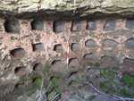
Columbarium 3 (Fig. 12). A round opening (diam. 1.1 m) of a shaft (depth 0.8 m) leading to an oval space (2.8 × 3.5 m, min. height 1.5 m) was discovered. Rows of niches were hewn in the walls of the shaft and the space—two rows in the shaft and at least five in the columbarium space.
Burial Caves 8 and 9. The openings of the caves are blocked by stones, so it was not possible to record the architectural plan of the caves.
Storage Cave (?) 10. The cave has a hewn entrance (width c. 1.3 m, height 1.5 m), which led to a space that was filled with alluvium; therefore the cave was not measured.
Cisterns 2, 4, 5, 6 and 11. Cisterns 2, 4, 5 and 6 are still in use and are covered by an iron lid. Cistern 11 was partly collapsed and filled with alluvium.
Cupmark 7. A hewn cupmark, 0.25 m in diameter and 0.2 m in depth, was found.
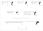
The Pottery Assemblage was collected on the surface, and it contains 16 identifiable rim sherds of locally manufactured vessels (Appendix — The Survey Data: Table 4). The assemblage includes early Hellenistic jars (Fig. 13:1–3), a Hellenistic jar (Fig. 13:4), a late Hellenistic–Early Roman jug/krater (Fig. 5:13) and a Byzantine krater (Fig. 13:6).
References
Amit D. 1977. A Forgotten Khan by the Wayside (Khan Gharib on the Road to Hebron). Papers for Tour Guides 1–4. Pp. 7–12 (Hebrew).
Amit D. 1997. Ritual Baths (Mikva’ot) from the Second Temple Period in the Hebron Mountains. M.A. thesis, The Hebrew University. Jerusalem (Hebrew).
Amit D. and Yezerski I. 2001. An Iron Age II Cemetery and Wine Presses at an-Nabi Danyal. IEJ 51/2:171–193.
Batz S. 2007. Continuity vs. Change in the Burial Customs of the Northern Hebron Mountains: From Iron Age II until the Byzantine Period. Judea and Samaria Studies 16:47–49 (Hebrew).
Bocher E. and Lipschits O. 2013. The "Yršlm" Stamp Impressions on Jar Handles: Distribution, Chronology, Iconography and Function. Tel Aviv 40/1:99–116. https://doi.org/10.1179/033443513X13612671397468
Cohen C. 2016. The Jewish Settlement in Northern Hebron Ridge from the Late Second Temple Period to the Bar Kokhba Revolt. M.A. thesis, Bar-Ilan University. Ramat-Gan (Hebrew; English summary, Pp. i-iv).
Conder C.R. and Kitchener H.H. 1883. The Survey of Western Palestine III: Judaea. London.
Kochavi M. 1972. The Land of Judah. In M. Kochavi ed. Judaea, Samaria and the Golan: Archaeological Survey in 1967–1968. Jerusalem. Pp. 19–89 (Hebrew).
Marcus M. and Amit D. 1989. Mount Hebron: Landscape-Survey and Hiking Routes. Jerusalem (Hebrew).
Ofer A. 1993. The Highland of Judah during the Biblical Period. Ph.D. Diss., The Hebrew University. Jerusalem (Hebrew).
Peleg Y. 2009a. Burial Caves and a Miqveh in Marah el-Jumma (Nabi Danyal). In I. Yezerski ed. Excavations and Discoveries in Benjamin and Judea (JSP 10). Jerusalem. Pp. 268–270 (Hebrew).
Peleg Y. 2009b. An Early Roman Period Burial Cave and a Miqveh in Khirbat Gharib. In I. Yezerski ed. Excavations and Discoveries in Benjamin and Judea (JSP 10). Jerusalem. Pp. 270–272 (Hebrew).
Raviv D. 2024. The Hiding Complexes of Judea: An Update Regarding Their Geographical Distribution, Typology and Function. Eretz-Israel 35:511–519 (Hebrew; English summary, p. 191*).
Raviv D. 2025. A Numismatic Survey at Ḥorbat Bet Zekharya and Possible Evidence for the Fifth Battle of Judah Maccabi. INR 20:89–122.
Rosenfeld B.N. 1991. The Settlement-History of Two High-Priestly Families during the Second-Temple period. In Y. Katz, Y. Ben-Arieh and Y. Kaniel eds. Historical-Geographical Studies in the Settlement of Eretz Israel 2. Jerusalem. Pp. 206–218 (Hebrew).
Zissu B. 2001. Rural Settlement in the Judean Hills and Foothills from the Late Second Temple Period to the Bar Kokhba Revolt. Ph.D. diss., The Hebrew University. Jerusalem (Hebrew).
Keywords
Hebron Hills, burial caves, shelf tombs, hiding complexes, columbarium, ritual baths, rock-cut installations, Iron Age, Hellenistic period, Hasmonean period, Hasmonean coins, rural settlement
Publication Date
07/10/2026
Report Type
Final Report