Nes Ẓiyyona, el-Khirba (A-9549)
Permit/License Number
A-9549
Excavation Report
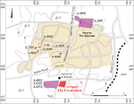
During April–May 2023, a salvage excavation was conducted at el-Khirba, Nes Ẓiyyona, south of the ‘Big Compound’ (Permit No. A-9549; map ref. 180725/647350; Fig. 1). The excavation, on behalf of the Israel Antiquities Authority and financed by Eyal Bek, was directed by A. Reiss (field photography), with the assistance of Y. Tepper (scientific guidance), Y. Amrani and Z. Lotan (administration), K. Serezo and R. Shnabel (probes), D. Golan (preliminary inspections, area preparation and consultancy), S. Emmanuilov (photography, drafting and photogrammetry), A. Dagot (GIS), N. Wieler (geology), Y. Nagar (physical anthropology), A. Gorzalczany (scientific guidance and consultancy), L. Rauchberger (consultancy), T. Harpak (pottery), K. Sorkin (digital scanning), Y. Gorin-Rosen (glass), D. Gazit (studio photography), D. Barkan and D. Citron from the IAA Tel Aviv district and workmen from Nablus.
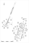
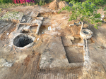
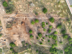
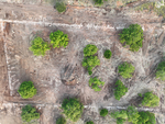
Five excavation squares were opened (Figs. 2–4; 3D model), and three strata (1–3) were exposed. Remains of a Muslim burial, which could not be dated, were assigned to Stratum 3. Two phases were identified in Stratum 2 and dated to the late Ottoman period and the British Mandate; remains of a well-house, a pool and an irrigation channel system were assigned to the early phase, and a lime pit was assigned to the late phase. A modern concrete block that decommissioned the well was attributed to Stratum 1. Soil samples for a geo-archaeological study were taken during the excavation (to be published in a dedicated future article).
According to the British Survey Map (PEF) from the nineteenth century CE, the area of the excavation was an agricultural area known as Biyarat ‘Abbud. Past excavations to the west and north of the area exposed mainly architectural remains from the late Ottoman period and the British Mandate (‘Ad 2017 [Fig. 1: A-5133, A-6373, A-6823]; Rauchberger 2020 [Fig. 1: A-8382]; and see references therein).
Stratum 3
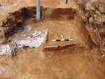
In the center of the excavation area, a human burial was exposed, including skeletal remains of the lower body of an individual interred in a primary burial and oriented approximately east–west (L138; Fig. 5; Y. Nagar, pers. comm.). The orientation indicates that this was a Muslim burial. The lack of accompanying artifacts prevented dating it. However, the burial was cut by the lime pit in Stratum 2; therefore, it may predate the late Ottoman period.
Stratum 2
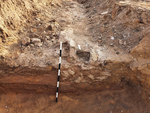
The Early Phase. The wall foundations of a rectangular well-house (L104; 4.30 × 17.45 m) with a round well (L108), and, to their west, a round pool (L106) that led to an irrigation channel system, were attributed to this phase. The walls of Well-House 104 (W109, W117, W121, W139; Fig. 6) were built of fieldstones bonded with reddish mortar, laid on the kurkar bedrock, and the building was oriented approximately north–south. A section of a floor bedding (L140) made of small fieldstones bonded with grayish mortar was exposed in the northern part of the building; it abuts W139 from the south.
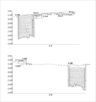
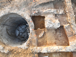
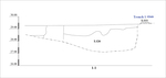
Well 108 (diam. 5 m; excavation depth 7 m; see Fig. 6) was dug into the ground and lined with ashlars bonded with gray mortar; 24 courses of the well were uncovered, but the excavation did not reach the bottom. A square kurkar construction (L116; 0.96 × 1.67 m, height 0.8 m; see Fig. 6), which may have served as a stand for a water-pump engine, was exposed 1.5 m south of the well. Based on the site’s location in the British Survey Map (PEF) and the historical groundwater levels, it seems that groundwater was reached 16–18 m below the surface when the well was used during the Ottoman period and British Mandate (N. Wieler, pers. comm.).
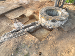
Pool 106 (diam 1.4 m, depth 1.5 m; Fig. 7) was built of kurkar stones and laid on the kurkar bedrock; it was plastered internally and externally with a mortar-like substance. It was used to feed the irrigation channels. A metal pipe that transported water to the channels was uncovered in the northern wall of the pool.
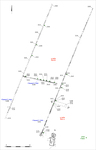
The irrigation channel system (Figs. 8–11) was comprised of three channels (1–3), which were constructed north of the pool to irrigate the citrus orchards (Fig. 8: Plots A and B). Channel 1 (L111; length 144 m, external width 0.7 m, internal width 0.3 m) and Channel 2 (L128; length 143 m, external width 0.85 m, internal width 0.28 m; Fig. 12) slope from south to north, while Canal 3 (L124; length c. 40 m, external width c. 0.7 m; internal preservation poor) slopes from west to east. The metal pipe that was exposed in the northern wall of Pool 106 led to Channel 1. The elevation difference between the exit of Channel 1 from Pool 106 and its northern end is 4.74 m. All three channels were built on a bedding of medium-sized fieldstones bonded with reddish mortar; their internal surface was plastered with gray hydraulic plaster. Chutes built from small stones bonded with gray plaster (length c. 1.5 m, external width c. 0.7 m, internal width c. 0.20 m, depth c. 0.5 m), which transported water to Plots A and B, were found in all channels. Six chutes exit Channel 1 eastwards, transporting water to Plot A. Three chutes exit the northern part of Channel 2 eastwards, transporting water to Plot B. No chutes were found in the southern part of Channel 2, suggesting that a residential building stood between Channels 1 and 2, south of Channel 3. Eight chutes exit Channel 3 northward, transporting water to Plot B. The eastern end of Channel 3 does not abut Channel 1. This may have occurred because a maintenance road for the orchards passed along Channel 1 in this space or because the slopes of the channels did not correspond. Channel 3 slopes west–east, following the natural topography, so it is more logical that it was connected to Channel 2 and was fed water from it (A. Gorzalczany, pers. comm.).
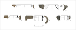
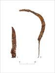
The Late Phase. West of the rectangular well-house, an irregularly shaped lime pit (L133; depth 1 m; see Fig. 5) was uncovered. It may have supplied material to repair the well-house, or for agricultural purposes. A few pottery sherds and two metal objects—a dagger (Fig. 14:1, L133, Basket 1023) and a sickle (Fig. 14:2; L133, Basket 1022)—were found discarded in this pit. The pottery includes a bowl (Fig. 13:1), a cooking pot (Fig. 13:2) and jars (Fig. 13:3–5), dating to the end of the Ottoman period and the British Mandate. The lime pit cut the upper body of the interred individual in Stratum 3.
Stratum 1
During this phase, Well 108 from Stratum 2 was blocked with modern concrete and went out of use.
Conclusion
The excavation uncovered burial remains (Stratum 3), which were probably Muslim and predated the late Ottoman period. During the late Ottoman period and British Mandate, there was a well-house, pool, irrigation channels (Stratum 2) and, in a later phase, a lime pit. Together, these formed part of an advanced orchard cultivation system, prevalent in the region during this time. Finally, the well was sealed with concrete (Stratum 1), probably during the British Mandate, marking the end of the well-house’s use.
References
‘Ad U. 2017. Nes Ẕiyyona, el-Khirba. HA–ESI 129. https://doi.org/10.69704/jhaesi.116.2004.25291
Rauchberger L. 2020. Nes Ẕiyyona. HA–ESI 132. https://doi.org/10.69704/jhaesi.116.2004.25742
Keywords
well-house, pool, irrigation channel system, lime pit, orchard farming, agricultural area, Biyarat ‘Abbud, Muslim burial, late Ottoman period, British Mandate
Publication Date
07/10/2026
Link to Excavation Repository
Report Type
Final Report