‘Ein Qinniyya, Sit Sha‘awany (A-9333)
Permit/License Number
A-9333
Excavation Report
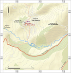
During August 2022, a trial excavation was conducted in the village of ‘Ein Qinniyya next to the holy Druze site of Sit Sha‘awany (Permit No. A-9333; map ref. 268314–46/793460–507; Fig. 1), prior to building a residential protected room (Mamad). The excavation, on behalf of the Israel Antiquities Authority and funded by the Home Front Command, was directed by R. Assis (area preparation, field photography and drafting), with the assistance of Y. Ya‘aqobi (administration), A. Kleiner (photogrammetry), T. Badichi (consultancy) and workmen from Kabul.
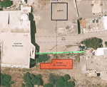
The excavation (100 sq m; Fig. 2) was located on a steep hill slope in the western part of ‘Ein Qinniyya, which extends north of Naḥal Sa‘ar on the southwestern slopes of the Hermon Ridge (Hartal 2017: Site 61; Assis 2025, and see additional description there). The excavation area (Fig. 3) was opened at the foot of a modern high retaining wall, and remains of retaining walls from the Byzantine period (Stratum II) and the late Mamluk–early Ottoman periods (Stratum I) were found. These remains were covered by modern refuse (depth c. 2 m), about half of which was construction debris that was tossed from the top of the hill down the slope, and the walls were uncovered once the debris was cleared.
A previous excavation further up the slope, about 30 m north of the present excavation (Assis 2025 [Fig. 1: A-8777]; see Fig. 2), uncovered the southern edge of a small archaeological tel, which may have controlled the water sources that fed the aqueduct leading to Banias. The settlement was occupied continuously from the early Byzantine–Umayyad periods (third–eighth centuries CE) and later during the Ayyubid period and from the Ottoman period to present day. Scattered pottery sherds from the Early Bronze Age II and the Hellenistic and Mamluk periods were also recovered.
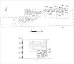
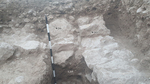
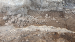
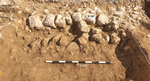
Stratum II—The Byzantine Period. The excavation exposed the eastern part of a wall (W212; width 0.6 m, preserved height 0.9 m; Fig. 4) built of fieldstones, some roughly hewn, perpendicular to the slope. The wall was built into a foundation trench (L215), which was densely filled with mud mixed with Golan Ware pottery sherds dated to the Byzantine period (fourth–seventh centuries CE). The foundation trench was sealed with a row of fieldstones (W211) placed on top of each other, adjacent to the southern face of W212, likely providing structural reinforcement. East of W212, a cluster of Golan Ware sherds (L213) was uncovered and dated to the Byzantine period (fourth–seventh centuries CE).
Stratum I—Late Mamluk–Early Ottoman periods. Remains of a retaining wall for an agricultural terrace (W206 on the west, W207 on the east; Figs. 5, 6) were uncovered. Wall 207 was founded on Walls 211 and 212 from Stratum II. The wall was constructed of two rows of large and medium-sized fieldstones, with a core of small stones. Pottery sherds dated to the late Mamluk–early Ottoman periods (fourteenth–sixteenth centuries CE) were found in the core of the wall, dating its construction. The wall was weakened during the Ottoman period, causing the southern row to collapse in spots and the stones from the core to spill down the slope (L209; see Fig. 4). Later, refuse was tossed from the top of the hill (L208, L210; see Figs. 5, 6), covering the wall and disconnecting the southern row of the retaining wall (W206) in its western part. Consequently, the wall went out of use. Pottery sherds from several periods were found in the accumulated refuse, the latest being small body sherds of Rashaya el-Fukhar ware, which indicate that the wall went out of use during the eighteenth–nineteenth centuries CE.
The walls that were exposed in the excavation were built perpendicular to the steep slope and used as retaining walls, perhaps for agricultural terraces. Nonetheless, the steep slope prevented agricultural activity, and the area became a place to dump waste. The walls join the remains previously uncovered to the north of the excavation (Assis 2025) and delineate the southern boundary of the nearby settlement.
References
Assis R. 2025. ‘Ein Qinniyya, Sit Sha‘awany. HA–ESI 137. https://doi.org/10.69704/jhaesi.116.2004.26603
Goren H. 2000. Pioneer Surveying and Mapping of the Galilee and the Hauran: The Map of the Sources of the Jordan River (1841) and the Map of the Ledja (1838). Cathedra 96:111–130 (Hebrew).
Hartal M. 2017. Map of Dan (8) (Archaeological Survey of Israel).
Keywords
Golan Heights, Nahal Sa'ar, Byzantine period, Mamluk period, Ottoman period, retaining walls, agricultural terraces, Rasheia al-Fukhar
Publication Date
07/10/2026
Link to Excavation Repository
Report Type
Final Report