Caesarea, Ha-Berosh Street (A-9643)
Permit/License Number
A-9643
Excavation Report
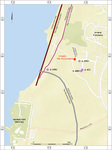
During August 2023, a salvage excavation was conducted on Ha-Berosh Street, Caesarea (Permit No. A-9643; map ref. 190843/712938; Fig. 1). The excavation, on behalf of the Israel Antiquities Authority and financed by the Caesarea Development Corporation, was directed by A. Gabay, with the assistance of Y. Amrani and Z. Lotan (administration), D. Kirzner (preliminary inspection and metal detector), S. Emmanuilov and A. Khalatov (photogrammetry, surveying, drafting and field photography), N. Wieler (geology), B. Goodman (tsunami events study), Y. Tepper (scientific guidance), P. Gendelman (pottery), Y. Gorin-Rosen (glass), G. Bijovsky (numismatics), I. Naor (metal laboratory) and L. Perry-Gal and A. Shatil (zooarchaeology). Assistance was also rendered by K. Sa‘id and A. Masarwa from the Haifa District and workmen from Asira ash-Shamaliya in the Nablus District.
The excavation was conducted on a sandy hill (10 m asl) in the periphery of ancient Caesarea, c. 400 m east of the aqueduct and 300 m north of the Byzantine-period city wall (see Fig. 1). Numerous excavations were conducted in Caesarea over the years (Porath 2013; Gendelman and ‘Ad 2019; 2023). The excavation area was opened within the boundaries of the northern city-cemetery (Porath, Ne’eman and Badḥi 1991 [Fig. 1: A-1681]; Avner and Gendelman 2007 [Fig. 1: A-3553]) in the vicinity of a previously discovered palace (Siegelmann 1974 [Fig. 1: A-412]; Permit No. A-4801), which may have belonged to an affluent agricultural landowner.
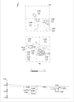
Four strata (1–4; Figs. 2, 3) were uncovered, including accumulations of soil and a habitation level with meager architectural remains, as well as pottery sherds, glass items and coins. Stratum 4, the lowest stratum, was dated to the Late Roman period, while Strata 1–3 were dated to the Byzantine period.
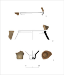
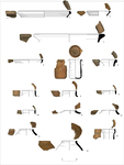
Stratum 4 is a dune of well-sorted quartz sand (L111, L112). A few pottery sherds dating to the Late Roman period were found in this stratum, including a cooking pot (Fig. 4:1) and amphorae (Fig. 4:2, 3).
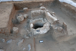
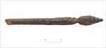
Stratum 3 consisted of a habitation level dated to the late Byzantine period, including dark-brown sandy sediment rich in pottery, bones and charcoal (L106, L108, L110). Meager remains of a wall (W113) and a ṭabun (L104, L107; diam. 0.6 m, depth 0.4 m; Fig. 5) were uncovered. The ṭabun is enclosed from east and south by two big standing stone slabs. The pottery assemblage is diverse relative to its small size, and it includes a CRSW bowl (Fig. 6:1), a krater (Fig. 6:3), a cup (Fig. 6:5), coastal bag-shaped jars (Fig. 6:7, 8), Gaza Ware jars (Fig. 6:12–14) and a saqiye jug (Fig. 6:15). A bone hairpin (L106, B1068; Fig. 7), typical of the fourth century CE, was also found.
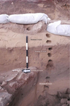
Stratum 2 consisted of brown sandy fertile soil (L105) containing a large assemblage of pottery, glass and tesserae. The interface between this stratum and the overlying one is level, suggesting that the top of Stratum 2 was truncated, and there was a sharp transition to the subsequent stratum. The pottery assemblage includes a CRSW bowl (Fig. 6:2), a krater (Fig. 6:4) and a coastal bag-shaped jar (Fig. 6:10).
Stratum 1 consisted of a yellow well-sorted sandy sediment (L101), which contained shell fragments and a few small pottery sherds, including an amphora (Fig. 6:6), a coastal bag-shaped jar (Fig. 6:9) and a Gaza Ware jar (Fig. 6:11).
The Glass Assemblage. Forty-three glass fragments were found in the excavation, 20 of which were identifiable and datable. The sherds are very small and worn and therefore were not drawn. The earliest fragment is of a cast bowl dated to the late Hellenistic or Early Roman period (L110). A bowl with a horizontal ridge below the rim (L103) was dated to the Late Roman period. Other finds include rims of Byzantine bowls and bottle fragments, including a bottle with an upright rim that was blown into a ribbed mold and decorated with a horizontal trail below the rim (L102), the foot of a wine goblet (L110) and an opaque dark green tessera (L107). These types are well known from other assemblages that were excavated in Caesarea and its surroundings as well as in the broader region.
The Coins. Twelve bronze coins were discovered, but only five could be identified with considerable difficulty. The assemblage is dated to the fifth–sixth centuries CE and includes nummi or minimi, with no monetary value. In a rich layer of finds (L105) in Stratum 2, three coins were found: one of Valentinian II (IAA 185652), one of Leo I (IAA 185650) and one dating to the first half of the sixth century CE (IAA 185651). In Stratum 3 (L106), there were two coins, one dated to 383–395 CE (IAA 185654) and the other dated to the first half of the fifth century CE (IAA 185653).
The coins predate most of the other finds in the same strata. This phenomenon is known from similar assemblages excavated in Caesarea and indicates continued use of coins minted in the fourth–fifth centuries CE during the sixth–first half of seventh centuries CE (Bijovsky 2012:75–102).
The excavation uncovered a habitation level and, above it, fertile soil, which were dated to the late sixth–early seventh centuries CE. The habitation level may be on the grounds of the palace that was exposed c. 150 m to its south, and it could be related to activities that took place there. The fertile soil may attest to agricultural land use northeast of Caesarea. The stratum of fertile soil is distinguished sharply from the overlaying stratum, indicating a sudden and rapid event. Study of the area surrounding Caesarea identified a tsunami event that affected the buildings of the city in 749 CE (Everhardt et al. 2023). The observed sharp transition between the strata suggests that the tsunami also affected areas northeast of Caesarea.
References
Bijovsky G.I. 2012. Gold Coin and Small Change: Monetary Circulation in Fifth– Seventh Century Byzantine Palestine (Polymnia: Numismatica antica e medieval; Studi 2). Trieste.
Everhardt IV C.J., Hendrik W.D., ‘Ad U., Sharvit J., Gendelman P., Roskin J., Robins L., Jaije R., Barkai O. and Goodman-Tchernov B.N. 2023. Earthquake, Fire, and Water: Destruction Sequence Identified in an 8th Century Early Islamic Harbor Warehouse in Caesarea, Israel. Geosciences 13/4:108. https://doi.org/10.3390/geosciences13040108
Gendelman P. and ‘Ad U. 2019. Caesarea Maritima — A View from Outside: The Periphery of the Roman and Byzantine Metropolis. In A. Lichtenberger, O. Tal and Z. Weiss eds. Judaea/Palaestina and Arabia: Cities and Hinterlands in Roman and Byzantine Times, Panel 8.6 (Proceedings of the 19th International Congress of Classical Archaeology Cologne/Bonn, 22 – 26 May 2018. Archaeology and Economy in the Ancient World). Heidelberg. Pp. 19–37.
Gendelman P. and ‘Ad U. 2023. Caesarea. HA–ESI 135. https://doi.org/10.69704/jhaesi.116.2004.26272
Porath Y. 2013. Caesarea Maritima 1: Herod’s Circus and Related Buildings (IAA Reports 53). Jerusalem. https://doi.org/10.2307/j.ctt1fzhdc0.5
Porath Y., Neeman Y. and Badiḥi R. 1991. Caesarea. ESI 9:132–134.
Siegelmann A. 1974. A Mosaic Floor at Caesarea Maritima. IEJ 24/3–4:216–221.
Keywords
Late Roman period, Byzantine period, cemetery, urban periphery, tabun, agricultural soil, tsunami, agriculture
Publication Date
07/10/2026
Link to Excavation Repository
Report Type
Final Report