Shibli, Ḥorbat Zelef (A-9341)
Permit/License Number
A-9341
Excavation Report
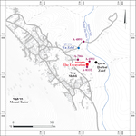
During July 2022, a trial excavation was conducted at Ḥorbat Zelef, in the eastern part of Shibli (Permit No. A-9341; map. ref. 238580/732635; Fig. 1), prior to construction. The excavation, on behalf of the Israel Antiquities Authority and financed by the Fadel Shibli family, was directed by R. Abu Raya (field photography), with the assistance of Y. Zilpa (administration), A. Ibrahim (photogrammetry) and archaeologists from the Lower Galilee and Valleys District of the IAA. Family members from the Fadel Shibli family also participated.
Ḥorbat Zelef extends along the southeastern edge of a flat limestone dome (c. 120 m asl) on the eastern slope of Mount Tavor, overlooking the fields of Kfar Tavor and Khan et-Tujjar, which are along an ancient road (Muqari and Gal 1998:47). Previous excavations uncovered remains of buildings from the Early, Intermediate and Middle Bronze Ages (Covello-Paran 2011 [Fig. 1: A-4891]; Mokari 2017 [Fig. 1: A-6931, A-7066]; Permit No. A-8332).
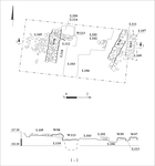
A rectangular excavation area was opened (c. 5 × 10 m, excavation depth 0.4–1.5 m; Figs. 2, 3). Remains of walls dating to the Early Bronze Age I and II (Stratum II; third millennium BCE) and a wall and robber trench from the Middle Bronze Age (Stratum I; first half of the second millennium BCE) were found. Probes conducted prior to the excavation identified additional remains of walls, pottery and flint.
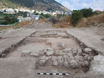
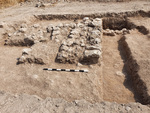
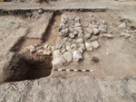
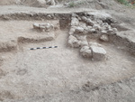
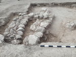
Stratum II—Early Bronze Age I and II. A segment of a wall (W113) oriented east–west and two north–south walls (W97, W98; Figs. 4–7) were uncovered. Wall 113 seems to continue below the northern part of W98; therefore, W113 presumably belongs to an earlier phase of the building.
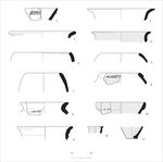
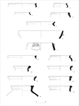
Wall 113 (length c. 0.6 m, width c. 0.45 m, height c. 0.2 m) was built of two rows of small stones set over an accumulation of light brown soil (L112, L114; depth c. 0.9 m) above the bedrock. In this accumulation, there were Early Bronze Age I and II pottery sherds, including fragments of a bowl (Fig. 8:1), jar (Fig. 8:9) and jug (Fig. 8:12).
Walls 97 and 98 were also set on this light brown soil accumulation. They were built of two faces of medium-sized rounded fieldstones, with a core of small stones and gray soil. Only one course of W97 survived (length c. 2.5 m, width c. 0.8 m, height c. 0.25 m), while two courses of W98 survived (length c. 3.3 m, width c. 1 m, height c. 0.6 m). The walls are parallel and probably belong to the same building.
An accumulation of light brown soil mixed with small stones (L109, L110, L112) was found next to the walls. In this accumulation, there were pottery sherds from the Early Bronze Age I and II, including rim fragments of three bowls (Fig. 8:2–4), three holemouth jars (Fig. 8:5, 7, 8) and two jars (Fig. 8:10, 11) and the base of an imported red-slipped jug (Fig. 8:13). A fragment of holemouth jar (Fig. 8:6) was found within W97 (L107).
Stratum I—Middle Bronze Age. Excavations uncovered a wall (W99; length c. 5.3 m, width c. 0.75 m, height c. 0.45 m; Figs. 6, 7) oriented northeast–southwest, deviating slightly from the orientation of Walls 97 and 98 in Statum II. The wall was founded on an accumulation of soil and built of flat stones, unlike the rounded stones of the previous stratum. A pile of stones (L105; Figs. 4, 5), visible on the surface, was uncovered in the western part of the area, and in the pile, there was an open cooking pot (Fig. 9:7). In the southern part of the excavation area, a robber trench (L106), which cut W97–W99 and L105 and was filled with fieldstones and gray soil, was exposed.
Pottery sherds dating to the Middle Bronze Age were found in soil accumulations (L111) west of W99, in the probe (L104) and in the robber trench, and they include bowls (Fig. 19:1–3), kraters (Fig. 9:4, 5), cooking wares (Fig. 9:6–9) and jars (Fig. 9:10–15).
Architectural remains from the Early and Middle Bronze Ages were uncovered in the excavation at a relatively shallow depth (depth c. 0.5 m). It seems that massive buildings stood here during these periods, and they were later severely damaged by the robber trench. The remains, located at the upper part of the slope, were probably also damaged by erosion.
References
Covello-Paran K. 2011. ‘En Zelef. HA–ESI 123. https://doi.org/10.69704/jhaesi.116.2004.1926
Mokary A. 2017. H̱orbat Zelef. HA–ESI 129. https://doi.org/10.69704/jhaesi.116.2004.25326
Muqari A. and Gal Z. 1998. Investigations at Khan et-Tujjar. ‘Atiqot 36:47*–55* (Hebrew; English Summary, p. 126).
Keywords
Mount Tabor, Early Bronze Age, Middle Bronze Age, structures, robber trench
Publication Date
07/10/2026
Report Type
Final Report