
‘Elabbon (A-9530)
Permit/License Number
A-9530
Excavation Report
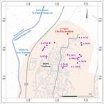
During April 2023, a trial excavation was conducted at ‘Elabbon (Permit No. A-9530; map ref. 237832–937/749871–926; Fig. 1), prior to the construction of a private home. The excavation, on behalf of the Israel Antiquities Authority, was directed by N. Silverberg (field photography), with the assistance of A. Shichman (probes), A. Kleiner (drone photography and photogrammetry), Y. Ya‘aqobi and Y. Zilpa (administration), R. Be’eri (scientific guidance), Y. Alexandre and E. Stern (pottery), H. Tahan-Rosen (pottery drawing), A. Shapiro (location map and studio photography) and workmen from Kafr Manda.
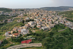
The excavation was conducted on the northern slopes of the spur on which the village of ‘Elabbon is located, on the eastern margin of the Bet Neṭofa Valley overlooking the town of Maghar, Naḥal Ẓalmon and the Ẓalmon reservoir. The ancient nucleus of the village extends across the top of the spur, and its water source was ‘Ein ‘Elabbon, which flows at the foot of the village west of Road 806. The site is identified as the ancient settlement of ‘Elbo—a Roman Jewish village that was home to the Ha-Koz (Chronicles 1, 24:10; Ezra 2:61; Klein 1945), one of the priestly divisions that fled from Jerusalem to the Galilee after the destruction of the Second Temple.
Previous surveys and excavations at ‘Elabbon uncovered few settlement remains and a large pottery assemblage, which indicate that the area was settled during the Iron Age II and the Roman, Byzantine, Early Islamic, Mamluk and Ottoman periods (Conder and Kitchener 1881:364, 381; HA 1963; Leibner 2009; Feig 2011 [Fig. 1: A-5878]; Gosker 2013 (Fig. 1: A-6528]; Cinamon 2015 [Fig. 1: A-6783]; Klein and Distelfeld 2023 [Fig. 1: S-1071]; Berger and Glick 2026 [Fig. 1: A-9446, A-9497]; Permit Nos. A-9636, A-9716, A-9862).
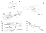
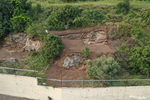
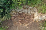
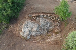
The present excavation (Figs. 2–4; 3D model) was conducted on a stepped slope that descending northward, with at least three agricultural terraces that were covered by dense vegetation. Preliminary probes identified pottery, quarrying marks and terrace walls. An ancient, probably Roman, quarry was exposed during the excavation, and over it, there were walls of agricultural terraces, which date to the Mamluk period at latest. The pottery assemblage that was collected during the excavation primarily dates to the Roman and Mamluk periods, but a few pottery sherds from the Byzantine and Early Islamic periods were also found.
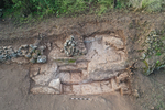
Ancient Quarry. Remains of a quarry (L10–L12; Figs. 5–7) were found throughout the excavation area, and they include stone-quarrying marks, quarrying steps, quarrying channels and severance channels. From the deepest excavation level, on one of the quarrying steps (L8), a few Roman pottery sherds, including a bowl, Kefar Ḥananya cooking pots and jars (not illustrated), were discovered.
Agricultural Terrace Walls. Remains of two parallel terrace walls (W3—exposed length c. 9 m; W9—exposed length c. 4 m; Figs. 6, 7) that were built directly on the bedrock were uncovered over the quarrying remains. The walls were built of dry construction, using small and medium-sized fieldstones, and they survived to a height of two to seven courses. Segments of the walls survived along the perimeter of the spur. Noticeably, the western part of W3 collapsed.
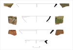
Mamluk-period pottery sherds were found on the surface over W3 (L2) and in the collapse-heap of W3 (L4, L7). The assemblage is uniform and was dated to the end of the thirteenth and beginning of the fourteenth centuries CE. Twenty-three pottery sherds were found, including 12 glazed bowls, nine cooking pots and cooking bowls and two handmade closed vessels. The glazed bowls (Fig. 8:1, 2) are a common type of simple bowls with monochrome, mostly green, glaze (Dalali-Amos and Getzov 2019:60). The cooking bowls (Fig. 8:3) have rounded walls that slope outwards and are glazed internally and externally (Dalali-Amos and Getzov 2019:55, Fig. 58). Among the cooking ware, there is a type of cooking pot with a globular body, no neck (Fig. 8:4) and sometimes horizontal strap handles attached to the wall (Dalali-Amos and Getzov 2019:55, Fig. 59).
Based on the uniformity of the assemblage, its relatively large size and the lack of material culture that post-dates the Mamluk period, the agricultural terraces, or at least the end of their use, can be dated to the Mamluk period.
The quarry that was exposed in the excavation joins the remains of another quarry discovered in the vicinity (Cinamon 2015), and the two indicate that the population of the ancient settlement quarried building stones in their immediate surroundings. The agricultural terraces were part of the rural hinterland of the ancient settlement and delineated it on the north. Dating agricultural terraces is a complex issue (see Davidovich et al. 2012). Nevertheless, the finds that were discovered during the excavation of the terrace walls may reflect human activity related to the hinterland during the Mamluk period. The few pottery sherds from the Byzantine and Early Islamic periods were probably washed into the area, and similar ones were found in other nearby excavations.
References
Berger U. and Glick A. 2026. ‘Elabbon (A-9446, A-9497). HA–ESI 138. https://doi.org/10.70967/1565-5334.1141
Cinamon G. 2015. ‘Elabbon. HA–ESI 127. https://doi.org/10.69704/jhaesi.116.2004.24819
Conder C.R. and Kitchener H.H. 1881. The Survey of Western Palestine I: Galilee. London.
Dalali-Amos, E. and Getzov, N. 2019. Remains from the Mamluk Period in the al-Waṭṭa Quarter, Safed (Ẓefat) (with a contribution by Oded Katz). ‘Atiqot 97:1*–97* (Hebrew; English summary, pp. 271–275). https://doi.org/10.70967/2948-040X.2041
Davidovich U., Porat N., Gadot Y., Avni Y. and Lipschits O. 2012. Archaeological Investigations and OSL Dating of Terraces at Ramat Rahel, Israel. JFA 37:192–208. https://doi.org/10.1179/0093469012Z.00000000019
Feig N. 2011. ‘Elabbon. HA–ESI 123. https://doi.org/10.69704/jhaesi.116.2004.1633
Gosker J. 2013. ‘Elabbon. HA–ESI 125. https://doi.org/10.69704/jhaesi.116.2004.2219
HA 1963: An Ancient Tunnel Near ‘Eilabun. HA 5:14–15 (Hebrew).
Klein E. and Distelfeld N. 2023. ‘Elabbon. HA–ESI 135. https://doi.org/10.69704/jhaesi.116.2004.26335
Klein S. 1945. Land of the Galilee: From the Time of Babylonian Immigration until the Redaction of the Talmud. Jerusalem (Hebrew).
Leibner U. 2009. Settlement and History in Hellenistic, Roman, and Byzantine Galilee: An Archaeological Survey of the Eastern Galilee. Tübingen. https://doi.org/10.1628/978-3-16-151460-9
Keywords
Quarry, Agricultural Terrace Walls, Roman period, Mamluk period
Publication Date
28/10/2026
Link to Excavation Repository
Report Type
Final Report