
Kafr Qasim (A-8786)
Permit/License Number
A-8786
Excavation Report
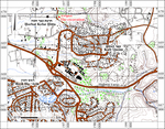
During July–September 2020, a trial excavation was conducted on the northwestern edge of Kafr Qasim (Permit No. A-8787; central map ref. 19674/66994; Fig. 1), prior to building a new neighborhood. The excavation, on behalf of the Israel Antiquities Authority and financed by the Ministry of Housing, was directed by J. Marcus with the assistance of Y. Agmon and A. Tendler (area supervision), S. Krispin (area supervision and metal detector), Y. Amrani and Z. Lotan (administration), D. Golan and D. Masarwa (supervision of mechanical equipment), Y. Tepper (scientific guidance), I. Jonish, M. Kahan and A. Wiegmann (digital documentation, surveying and drafting), A. Peretz (photography), Y. Gorin-Rosen (glass), P. Gendelman (pottery), Y. Nagar (physical anthropology), Y. Drey (consultation), J. Roskin (geology), A. ‘Azab from the IAA and workmen from Umm el-Faḥm, Bir el-Maksur and Sebastia.
The excavation was located on both sides of a streambed known by the local inhabitants as Wadi Abu ‘Amran. Horbat Kefar Ḥiṭṭa (Khirbat Kafr Ḥaṭṭa) and Kafr Qasim are near the excavation, and during Rosh Ha-‘Ayin Map Survey, remains of an Arab village, a Sheik’s tomb and an ancient settlement were documented, and pottery dating to the Chalcolithic period, the Early and Middle Bronze Ages and the Byzantine and Early Islamic periods was collected (Kochavi and Beit-Arieh 1994: Sites 3, 4, 15). Nowadays, this area is built up with olive orchards and industrial buildings. According to the testimonies of local inhabitants, the Sheik’s tomb is not preserved, and it was the last evidence of the burial area of the central settlement. Apparently, the ancient settlements at Kafr Qasim and Kafr Ḥaṭṭa co-existed side by side (Avi-Yonah 1976:72; Tsafrir, Di Segni and Green 1994:165). Research demonstrates that Kafr Ḥaṭṭa was occupied at least until the sixteenth century CE (Grossman 1994:190; Marom 2022:103–104), and its center moved southeast by about 1 km during the Ottoman period (Grossman 1994:190). No excavations were so far conducted within Kafr Ḥaṭṭa and Kafr Qasim.
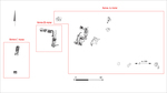
Three excavation areas were opened in the current excavation (A–C; Fig. 2). Various architectural remains and installations as well as considerable finds from the Roman, Byzantine and Early Islamic periods were found in Area A. Other finds include three hewn tombs, including a shaft tomb from the Middle Bronze Age, a cist tomb and a hewn arcosolium, which was probably part of a double-arcosolia tomb, as well as two quarried burial caves from the Roman and Byzantine periods. In Area B and C, excavations uncovered building remains and stone and mosaic floors from the Roman and Byzantine periods. Pottery from the Bronze Age and the Early Islamic and Mamluk periods was also found.
Area A. In this area, the excavation revealed installations, including a hewn winepress and bodeda, stone quarries, a segment of an agricultural road, underground spaces and a hewn and plastered reservoir with steps. Numerous pottery sherds were found, including bowls, jars, jugs and intact oil lamps, which date to the Roman, Byzantine and Early Islamic period. Various types of glass vessels and waste dating to the Roman and Byzantine periods were also found as well as coins minted in various cities in Israel during the Roman period. The glass waste suggests the glass vessels were manufactured locally during the Roman and Byzantine periods. Based on the remains and finds uncovered in this area, it was likely part of an industrial zone on the fringe of the settlement.
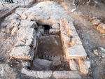
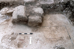
The shaft tomb was not fully excavated, but it was dated to the Middle Bronze Age based on the pottery found inside. No in situ finds were discovered in the cist tomb. The hewn arcosolium that was uncovered is probably part of a double-arcosolia tomb that was damaged during looting. The two burial caves are loculi caves, and one of them was looted. In the first burial cave, there were no in situ finds, apart from a few non-diagnostic sherds of cooking pots and an intact oil lamp from the first–second centuries CE that was found in a pit hewn in the center of the standing space, into which the bones of the interred were swept from the loculi and collected. The second burial cave was sealed with a rolling stone, and in front of it, there was a hewn and built courtyard (Fig. 3). The pottery assemblage from the two burial caves dated to the Roman and Byzantine periods and includes cooking ware and oil lamps, which probably served as grave goods or were used for funerary rituals. Glass vessels and bone objects from the Roman and Byzantine periods were also found, in addition to a variety of metal objects, including bells, jewelry and cosmetic utensils.
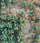
Area B. Two adjacent buildings were exposed in this area (Fig. 4; Building 1 and 2). The northern, eastern and western walls of Building 1, which delineate three rooms (1–3), an internal courtyard (4) and a corner of two walls (5) were uncovered. All the walls of the building were constructed from a single row of hewn stones with no mortar or plaster. Remnants of a plaster floor that was founded on soil and bedrock were uncovered in Room 1 in Building 1. A stone floor and a threshold were uncovered in Courtyard 4, which was built between Rooms 2 and 3; these are typical of residential houses. Wall Corner 5 was discovered next to the western wall of the building, and its construction method differs. The external and internal faces of both walls forming the corner are plastered, and abutting the walls is a stone floor. Two rooms (1, 2) were uncovered in Building 2. In Room 1, remnants of a poorly preserved multi-colored mosaic floor were found. In Room 2, a stone floor, probably outside the building, was uncovered. The buildings in this area dated to the Late Roman and Byzantine periods based on pottery.
Area C. A building that was blocked by a collapse-heap of building stones and architectural elements was uncovered in this area. The building has four rooms, with floors uncovered in three. Two layers of floors were identified in one room: an earlier white plaster floor and a later packed earth floor. In another room, a poorly preserved floor-bedding made of crushed limestone was exposed. The third room was paved with a multi-colored mosaic, which included a black frame and a red geometric design that was preserved in only a small segment (Fig. 5). A rich pottery assemblage was uncovered in this area, and it included cooking and table ware and oil lamps. Basalt tools, the base of a column and a fragment of an architrave were also found. Based on pottery, the building was dated to the Late Roman period, and it remained in use during the Byzantine period.
The excavation uncovered few remains of a settlement from the Late Roman and Byzantine periods. However, the industrial installations, stone quarries and burial caves indicate that this was a permanent settlement with activity areas and installations near its boundaries. The excavation was conducted at the fringes of the ancient settlement, which likely extended beyond the excavation area. Based on the remains and the finds from Area A, this was part of the industrial zone. The stone and mosaic floors that were found in the buildings in Areas B and C and the architectural elements in Area C are indicative of a monumental construction. The finds that were collected in the burial caves indicate that they were continuously used from the Early Roman period and through the Byzantine period. The range of grave goods in the caves may reflect the high social and economic status of the interred. This type of burial cave was usually used for a single family who lived close by, which was used over several generations.
References
Avi-Yonah M. 1976. Gazetteer of Roman Palestine (Qedem 5). Jerusalem.
Grossman D. 1994. Expansion and Desertion: The Arab Village and Its Offshoots in Ottoman Palestine. Jerusalem (Hebrew).
Marom R. 2022. The Renewed Arab Settlement in the Sharon Plain and Western Samaria, 1700-1948. Ph.D. diss. University of Haifa. Haifa (Hebrew; English summary).
Kochavi M. and Beit-Arieh I. 1994. Map of Rosh Ha-‘Ayin (78) (Archaeological Survey of Israel). Jerusalem.
Tsafrir Y., Di Segni L. and Green J. 1994. Tabula Imperii Romani; Iudaea-Palaestina: Eretz Israel in the Hellenistic, Roman and Byzantine Periods; Maps and Gazetteer. Jerusalem.
Keywords
settlement remains, building remains, installations, industrial area, mosaic floor, stone quarries, burial caves, tombs, shaft tomb, arcosolium, cist tomb, Middle Bronze Age, Late Roman period, Byzantine period, Early Islamic period, Ḥorbat Kefar Hitta
Publication Date
01/11/2026
Report Type
Preliminary Report