
Tel Aviv, Pinḥas Lavon Street (A-9092)
Permit/License Number
A-9092
Excavation Report
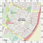
During August 2021, a trial excavation was conducted on Pinḥas Lavon Street in south Tel Aviv (Permit No. A-9092; map ref. 178591–606/ 661276–331; Fig. 1) prior to construction of a bicycle lane. The excavation, on behalf of the Israel Antiquities Authority and funded by NTA Ltd., was directed by M. Viezel, with the assistance of Y. Amrani and Z. Lotan (administration), I. Jonish (surveying and drafting), A. Wiegmann and C. Segal (field photography, surveying and photogrammetry), A. Tamir (metal detection), A. Dagot (GIS), D. Gazit (studio photography), M. Abu (plans), I. Taxel (pottery), Y. Gorin-Rosen and T. Winter (glass; Appendix 1), L. Perry-Gal and M. Hater (archeozoology; Appendix 2), I. Reznitsky (metal laboratory), A. Shapiro (flint tools), Y. Tepper (scientific guidance), A. Gorzalczany, Y. Elisha, L. Rauchberger and A. Sasson (consultancy), D. Barkan and D. Abu-Salah from the IAA Tel Aviv District and workmen from the area of Nablus.
Rapid development of Yafo started in the mid-nineteenth century and was attributed to Egyptian immigration and the settlement of a new population in the city and its surrounding (Grossman 2009). Agricultural and technological aspects of this development are evidenced by the extension of the citrous orchards around the city and the establishment of orchard houses, which contained wells (biarot), pools, a system of irrigation canals, farm buildings and sabil (Sasson 2009). As the orchards grew and moved farther from the city, the need for well-houses for the farmers and owners increased. A few well-houses are known in the excavation’s vicinity; the closest is Biarat Musai, about 100 m north of the excavation (Sasson 2009:65–66; Reiss 2026 and see there references therein to other nearby well-houses).
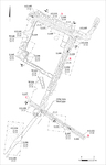
Five squares were opened in the present excavation (Figs. 2, 3), and a system of water canals and the remains of a building, perhaps part of a well-house, dated to the end of the Ottoman period, were uncovered. The finds from the excavation include predominantly fragments of pottery and glass vessels, numerous metal objects and faunal remains.
Water Canals
Excavations uncovered four water canals (A–D) built of small and medium-sized kurkar stones bonded with reddish mortar and founded on the local ḥamra soil. The interior of the canals was coated with a gray plaster over a base of white mortar (thickness c. 1 cm). In Canals A–C, gray plaster was preserved also on the upper face of the canals’ walls. The canals were not fully exposed, and they continue outside the excavation boundaries. According to the testimonies of local residents, there was a well west of the excavation area, which was covered by the construction of the road; this well may have fed the canals, but this cannot be proved. Metal objects that would have been used in a saqiye well were found, suggesting a well existed nearby.
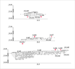
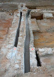
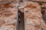
Canal A (L105; exposed length c. 16 m, max. depth 0.45 m). The canal was founded on a fill of mortar and small fieldstones. Its southern wall is shared with Canal B (Fig. 4). The canal slopes northwest–southeast. Two use-phases were identified (Fig. 5): an early phase (L111), in which the canal was at its maximum depth, and a late phase (L149), in which the canal floor was raised.
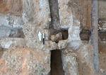
Canal B (L104; exposed length c. 29.5 m, max. depth 0.45 m). The canal slopes northwest–southeast. Its wall thickness is uneven; the eastern side is 0.2 m thick, while the western side is 0.5 m thick. Two phases were identified in the eastern wall of the canal; in the early phase, the wall was plastered, while in the late phase, it was raised with small fieldstones with no mortar or plastering. In the southern third of the canal where it joins Canals C and D, a small rectangular pool was uncovered (0.22 × 0.40 m; Fig. 6), which probably regulated the water flow before it was directed to the two additional canals. A segment of a clay pipe (diam c. 0.12 m) survived at the junction of Canals C and D, and it may have facilitated the water flow. East of the canal in this section, there was a modern steel pipe that damaged the canal’s eastern wall.
Canal C (L137; exposed length c. 1.8 m, depth c. 0.2 m). The canal branches off Canal B to the northwest. Since only a small section of this canal was exposed, it is difficult to identify its orientation; however, it seems to slope east–west. During a later phase, this canal was blocked with gray mortar where it branches from Canal B, and it probably went out of use; the reason for this could not be determined by the excavation.
Canal D (L107; exposed length c. 9 m, depth c. 0.2 m). The canal branches from Canal B to the east and slopes west–east. In its western side, plaster remnants were found, which may indicate that there was a later phase with a raised floor here as well. In Canal D, a segment of a clay pipe (diam. c. 0.12 m) was also preserved.
Building Remains
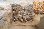
Excavations revealed two walls that form a corner (W133, W148) and a pillar (L145; 1.3 × 1.5 m; Fig. 7) built between them. The walls and pillar were built of fieldstones and survived to a maximum height of ten courses. Both walls abut Canal B and delineate a square architectural compound. Most of the finds from the excavation were collected in this compound, which dates to the Ottoman period. They include fragments of pottery and glass vessels (see Appendix 1), a single flint stone, numerous metal objects and animal bones. This square compound may have been an open courtyard of a building further west, which was not uncovered in the excavation.
The Finds
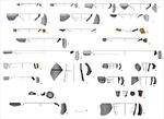
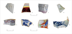
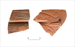
The pottery assemblage from the excavation dates to the Ottoman period and comprises local vessels, including Black Gaza Ware, and imports. The local vessels include bowls (Fig. 8:1–14), cooking pots (Fig. 8:15), a holemouth jar (Fig. 8:16), a saqiye jar (Fig. 8:17), jugs (Fig. 8:18–21), a flowerpot (Fig. 8:22), a tobacco pipe (Fig. 8:23), a beehive vessel (Fig. 8:24) similar to ones found at Tell Yaba (Tsuk, Bordowicz and Taxel 2016: Fig. 37:6) and a clay pipe (Fig. 8:25). The imports include decorated porcelain bowls (Fig. 9:1–7), among them a bowl with a lion stamp (Fig. 9:4) and a coffee cup (Fig. 9:8). There are also many clay tiles, including Marseille tiles (Fig. 10).
The glass assemblage from the excavation is dated from the end of the nineteenth century to the twentieth century CE (see Appendix 1).
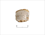
The flint found in the excavation is worked and used as a gunflint for a flintlock firearm (Fig. 12).
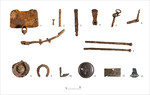
The metal objects include tools, some related to agriculture, and objects related to the saqiye well and building that were probably nearby. These include a hoe (Fig. 11:1), implements used in a saqiye well (Fig. 11:2, 3), a chisel (Fig. 11:4), an implement for tethering animals (Fig. 11:5), a hinge of a door or window (Fig. 11:6), iron nails (Fig. 11:7), an enamel bowl (Fig. 11:8), a horseshoe (Fig. 11:9), a plough’s blade (Fig. 11:10), a decorated copper bowl (Fig. 11:11), a decorated copper plaque (Fig. 11:12) and a nargileh’s head (Fig. 11:13). The decorated copper plaque may have been the cover of a utensil or tobacco box.
The Faunal Remains
Lee Perry-Gal and Mohammed Hater
The faunal remains were uncovered in the irrigation canals and their surrounding area (depth 0.4–1.0 m), together with pottery sherds and small finds dated to the Ottoman period. The bones were collected manually in a single standard archival box. Identification was done using the comparative collection of the archeozoological laboratory of the University of Haifa. The bones were identified to species and skeleton part according to the protocol of Davis (Davis 1992), and taphonomic marks were examined to identify cutmarks (Seetah 2006), pathologies (Bartosiewicz 2008), gnawing by carnivores (Fisher 1995) and burning (Stiner et al. 1995). The ages of the goat/sheep, cattle and camel were determined by the level of bone-fusion (Haber 2001) and eruption/wear of teeth (Payne 1973). Weathering and environmental damage were examined according to Behrensmeyer’s categories (Behrensmeyer 1978). The level of fragmentation was described according to the bone-completeness index (percentage of the complete bone).
The assemblage (Appendix 2) was comprised of many bone fragments and 14 bones and teeth, which belong to camel (N=7), goat/sheep (N=4) and cattle (N=3). Most bones of goat/sheep and cattle were fused, and the teeth were permanent, indicating these were adults.
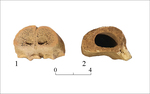
Examination of the bone surfaces indicated that they were not exposed to fire or damaged by weathering or carnivore and rodent gnawing. Therefore, they were buried soon after consumption. Most of the taphonomic marks are probably man-made. Cutting and sawing marks were identified on five skeletal parts of goat/sheep and cattle (Appendix 2:1–5); the cutmarks are typical of separating meat from bones, and the sawing marks are typical of bone processing (Fig. 13:1, 2).
The identification of most remains as those of adult individuals may indicate goat/sheep and cattle were used for secondary products such as milk and wool, as well as herd maintenance. The worked bones show that bones were used as raw material. The manufacturing techniques and types of worked bones that were found in the excavation are consistent, for example, with decorative elements used in furniture (cf.: Choyke and O’Connor 2013).
Conclusion
The excavation exposed a system of canals and walls from the end of the Ottoman period. The proximity between the canals and walls suggests that they were constructed and used at the same time. Two construction phases were identified in the canals. In addition, they have several characteristics that distinguish them from other canals in the vicinity, including the wall shared by Canals A and B, the particularly high walls and the lack of irrigation openings. These characteristics may indicate that the canals’ function was to transport water to distant plots (Sasson 2020). The source of the canal water was not identified. The northern Canal A may have been fed by Biarat Musai, which is adjacent to the north, while Canal B, which feeds Canals C and D, was fed by a water source west of the excavation. The two walls that were uncovered in the excavation were probably part of an open courtyard of a large residential building, perhaps a well-house located outside the excavation boundaries. The large quantities of finds that were uncovered indicate daily human activity and reinforce the assumption that there were residential buildings nearby.
References
Bartosiewicz L. 2008. Taphonomy and Palaeopathology in Archaeozoology. Geobios 41/1:69–77. https://doi.org/10.1016/j.geobios.2006.02.004
Behrensmeyer A.K. 1978. Taphonomic and Ecologic Information from Bone Weathering. Paleobiology 4/2:150–162. https://doi.org/10.1017/S0094837300005820
Choyke A. and O'Connor S. eds. 2013. From these Bare Bones: Raw Materials and the Study of Worked Osseous Objects. Oxford. https://doi.org/10.2307/j.ctvh1dgv3
Davis S.J.M. 1992. A Rapid Method for Recording Information about Mammal Bones from Archaeological Sites (Ancient Monuments Laboratory Reports 92/19). London.
Fisher J.W. 1995. Bone Surface Modifications in Zooarchaeology. Journal of Archaeological Method and Theory 2/1:7–68. https://doi.org/10.1007/BF02228434
Grossman D. 2009. The ‘Tel Aviv District’ Settlements in the Ottoman Period—the Village, the Economy and Customs. In E. Ayalon ed. The Secret History of Tel-Aviv: What Happened Here in the Last 20,000 Years? Tel Aviv. Pp. 153–176 (Hebrew).
Haber A. 2001. The Faunal Analysis of Hagoshrim: Biological and Economic Aspects of Prehistoric Agricultural Societies and the Process of Domestication. MA Thesis, Tel Aviv University. Tel Aviv.
Payne S. 1973. Kill-Off Patterns in Sheep and Goats the Mandibles from Asvan Kale. AnatSt 23:281–303. https://doi.org/10.2307/3642547
Reiss A. 2026. Tel Aviv, Qiryat Shalom (A-9376). HA–ESI 138. https://doi.org/10.70967/1565-5334.1147
Sasson A. 2009. Biara and Orchard Houses in Jaffa and its Environs. In M. Zur and S. Rotbard eds. Neither in Jaffa nor in Tel Aviv: Stories, Testimonies and Documents from Shapira Neighborhood. Tel Aviv. Pp. 59–69 (Hebrew).
Sasson A. 2020. What do the Water Tunnels Tell Us? A Proposal for a Methodology to Research Historic Irrigation Systems. Atarim 10:131–138 (Hebrew).
Seetah K. 2006. Butchery as an Analytical Tool: A Comparative Study of the Romano-British and Medieval Periods. Ph.D. diss., University of Cambridge. Cambridge.
Stiner M.C., Kuhn S.L., Weiner S. and Bar-Yosef O. 1995. Differential Burning, Recrystallization, and Fragmentation of Archaeological Bone. JAS 22/2:223–237. https://doi.org/10.1006/jasc.1995.0024
Tsuk T., Bordowicz I. and Taxel I. 2016. Majdal Yābā: The History and Material Culture of a Fortified Village in Late Ottoman- and British Mandate-Palestine. JIA 3:37–88. https://doi.org/10.1558/jia.v3i1.31876
Keywords
Yafo, biarot, wells, citrous orchards, irrigation canals, Ottoman period, orchard houses, Biarat Musai, beehive vessel, saqiye well
Publication Date
02/11/2026
Link to Excavation Repository
Report Type
Final Report