Yafo, the Harbor (A-8993)
Permit/License Number
A-8993
Excavation Report
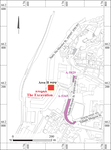
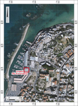
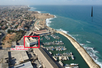
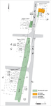
In March 2021, a salvage excavation was conducted in the offices of the British Mandate-period Customs House, next to the southern gate of the port of Yafo (Permit No. A-8993; map ref. 176518-28/662176-200; Figs. 1–3), prior to building a hotel. The excavation, on behalf of the Israel Antiquities Authority and funded by Africa Israel Ltd., was directed by E. Haddad (field photography), with the assistance of D. Golan (probes), Y. Amrani and S. Suisa (logistics and administration), S. Emmanuilov (surveying and photogrammetry), A. Peretz (field photography), Sky View (aerial photography), A. de Vincenz (Ottoman-period pottery), T. Winter (glass), L. Sandberg (numismatics), J. Raskin (soil sampling and analytical field laboratory), M. Halevi Bar (Old Yafo Conservation supervision), D. Barkan (IAA Tel-Aviv-Yafo District), D. Planer (IAA Department of Marine Archaeology), and Palestinian workers. I am grateful to Architect S. Giller for consultation during the excavation, to A. Appelbaum, the site foreman, and to A. Kolker and Y. Krovachenko, the construction project directors for the help in logistics during the excavation.
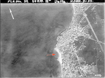
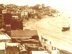
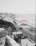
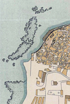
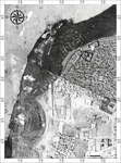
The excavation was located in the southern part of the harbor, in an area significant archaeologically and geomorphologically for understanding the dynamics of the sea currents and sand accumulation in the harbor. Since the late nineteenth century, a sandy bay here was known as ‘Birket el-Qamar’– the ‘Moon Pool’, named after its crescent shape and light sandy shore (Fig. 4; Giller 2016; Haddad et al. 2020), The sand movement in the bay was dynamic, its name also attesting to its shifting shape. When sand accumulated in the bay, it was possible to drag a vessel up to the shore, while when a strong storm swept sand out from the bay to the sea, it could be used as a small anchorage (Haddad 2013:310). During the nineteenth and early twentieth centuries, the water reached very close to the harbor buildings (Fig. 5). Aerial photographs from the 1920s show that the crescent-shaped sandy shore had disappeared, since storms swept the sand back to sea. This problem concerned the Ottoman administration, until they eventually built a long wall along the shore-line preventing sand from being swept back to sea, and creating a sandy area protected from the waves (Fig. 6). Giller noted that this area was used until the end of the nineteenth century, for bathing and to unload barrels of crude oil, and that when the harbor activity was extended in 1905 to include the export of oranges, an ‘orchard house’ was built, with a low wall on its south, protecting the sandy strip where the fruit produce was now stored in the open air (Giller 2016:202–203). This wall appears on the 1918 Egyptian survey map (Fig. 7; British Mandate Archives, Israel Antiquities Authority) as a straight wall built in a north–south direction on the seashore and reaching to the center of ‘Birket el-Qamar’. To the west of this wall, another wall appears in photographs and aerial photographs from the British Mandate period, close to the waterline on the crescent-shaped coast (Fig. 8; see, for example, Abramowitz 2015:132); it was designated by the author the ‘sand-trapping wall’. Two staircases descending from the wall towards the waterline were built at the southern part of this wall extension, and an east–west wall was built parallel to the southern end of the wall (Giller 2016: Fig. 10).
Birket el-Qamar no longer exists due to the construction in the 1930s of Hangars 1 and 2 and the customs house in the southern part of the harbor. The customs house, built at the center of the Birket el-Qamar crescent, remained in use as the Yafo port administration offices until 2008 (Abramovich, pers. comm.). When the building was renovated prior to the construction of the hotel, a section of a massive ashlar wall (W103, see below) was uncovered, and since its location accords with the Ottoman-period ‘sand-trapping wall’, an excavation was carried out.
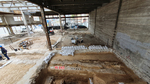
Four excavation squares were opened (Area H; Figs. 9, 10; 3D model) next to W103 (exposed length 22.5 m; width 1.3 m)—three to its west (Squares 1–3) and one (Square 4) to its east—aiming to expose its full length and examine both its faces. Two strata were uncovered: earlier Stratum II dating to the late Ottoman period (early twentieth century), and later Stratum I, with two phases B and A, from the British Mandate period.
The excavation continues previous excavations at the harbor (Haddad and Glick 2022, with further references). A segment of a Crusader-period moat was uncovered in Yehuda Ha-Yammit Street excavation, (Haddad and Rauchberger 2019; [Fig. 1: A-5365]). In Ha-Migdalor Street, north and east of the current excavation, a pile of Byzantine-period accumulated refuse, containing many Gaza-ware jars and imported amphorae, was uncovered (Haddad 2015; [Fig. 1: A-5829]).
Stratum II
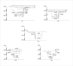
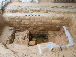
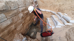
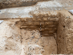
Square 1 (Fig. 11). Nine courses of W103 (height c. 1.8 m) were uncovered in a probe next to its western face; the lowest course is sunk at 0.14 m below sea level. The western face of the impressive wall was built of rectangular ashlars, most with drafted margins and a raised boss; the stones in the lower courses are larger than in the upper ones. At mid-height the wall shows wear-marks, probably from contact with the waves. The upper part of the wall was dismantled during the building of the Customs House in 1936 (see Stratum IA, below). The core of the wall, including gray hard mortar, was partially exposed, and the space between the stones was also bonded with the same material. About mid-height and adjacent to the wall on the west, construction debris was uncovered (L107), containing small and medium-sized kurkar stones, British Mandate brick fragments, rusted irons, marine encrustation such as Glycymeris nummaria, and numerous fragments of Marseilles tiles (Fig. 12), manufactured since the second half of the nineteenth century. This debris may be part of a fill laid down in the course of building the Customs House. Application of fine air-pressure drilling deep down the section, west of the wall and below sea level (Fig. 13), showed that the bottom course of the wall was laid over a stone foundation projecting beyond it by about 0.1 m; the depth of the foundation not known. The drilling also exposed an impenetrable packed layer of stones (0.3 m below sea level) to the west of the lower course of the wall.
Square 2 (Fig. 14). Seven courses of the western face of W103 were exposed. Here too, accumulated construction debris (L110) containing stones, irons and many Marseilles rooftiles was exposed next to the western face of the wall. A British Mandate 5-mil coin was found in a probe dug into the accumulated debris, and a layer of shell fragments (L114) was uncovered below the debris accumulation (0.31 m asl).
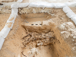
Square 3 (Fig. 15). The top two courses of the western face of W103 were uncovered. A large cache of rusted irons stuck together (L111) was found west of the wall, extending beyond the probe limits. A rectangular timber beam found next to the western side of the wall was possibly part of a railway sleeper, a remnant of the iron railway laid here in the 1930s to allow transport of construction materials to the harbor, after part of Birket el-Qamar had dried up. Two British Mandate 5-mil coins were found in the sand fill above the iron cache.
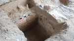
Square 4 (Fig. 16). Aligning with the constructor’s restrictions, a small area was excavated next to the eastern face of W103, revealing that the wall was built of medium-sized, smoothed ashlars without drafted margins, and carelessly smeared with gray mortar. A 5–10 cm thick layer of shell fragments was uncovered here abutting the wall, and below it, a sandy fill (L109) containing a bronze fals dated to the reign of the Mamluk Sultan Baybars (see below) abutted the wall. This is the first coin of Baybars found in the harbor area, joining three other Baybars coins retrieved in Yafo (Peilstöcker et al. 2006; Permit Nos. A-2374, A-5463; R. Kool, pers. comm.). About 4,200 coins have so far been found in Yafo, only 32 of which are Mamluk, a small number compared to other sites. The excavation continued with mechanical equipment down to a solid surface of stones or bedrock (c. 0.16 m asl), as further manual excavation was not possible due to safety restrictions.
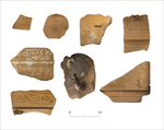
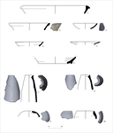
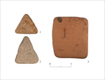
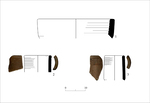
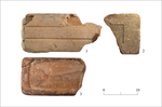
The Finds. Ottoman-period pottery sherds retrieved in the excavation include a Black Gaza Ware bowl (Fig. 17:1) and krater (Fig. 17:6), glazed bowls (Fig. 17:2, 3), white porcelain vessels (Fig. 17:4, 5), three kizans (Fig. 17:7–9) and a jara-type jar (?; Fig. 17:10). The function of two small pottery sherds—one shaped as an equilateral triangle (Fig. 18:1), the other as an isosceles triangle (Fig. 18:2)— is not known, whilst a larger worn square pottery sherd fragment was probably shaped from a floor tile (Fig. 18:3). Other finds include three fragments of British Mandate clay sewage pipes (Fig. 19:1–3) and three bricks (Fig. 20:1–3). Brick No. 1 is a hollow brick of the ‘six holes’ type, that may have been brought from Jerusalem, since this type was manufactured in the factory at the Schneller Syrian Orphanage since 1896 (Gordon 2006:63). Brick No. 2 is a chamotte brick bearing the letter E, probably the end of REFRACTAIRE SUPERIEURE, an inscription known from the Mizgaga Factory in Kibbutz Naḥsholim (Zilberstein 2020: Fig. 11).
A few glass vessel fragments dated to the nineteenth–twentieth centuries CE, mostly necks and bases of bottles (L107, L111, L112) and fragments of windowpanes (L100, L111) were found in the excavations, most fragments made of glass in green hues, and a few of colorless glass. Most fragments are worn, apparently due to a long duration under water.
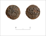
The bronze fals found in Square 4 (L109, IAA No. 180142; Fig. 21), dated to the reign of Sultan Baybars (1260–1277 CE), bore an inscription on the obverse: ‘the Sultan/the King al-Zahir’, with an image of a lion after ‘the Sultan’, and on the reverse: ‘There is no God but Allah, and Muhamad is the messenger of Allah’ (Balog 1964:106, No. 101).
Stratum IB
This phase had a limited appearance in Square 4. Two square cast cement lumps (W113; Fig. 16) were found, perhaps remnants of an east–west wall built over Stratum II W103. It seems that the cement was poured into frames placed over a bedding of fieldstones above the sand; poorly preserved remnants of a rusted barrel were found next to the lower part of W113.
Stratum IA
The foundations of the Customs House built in 1936 were found in all the excavation squares (Fig. 22). When its exterior walls were dismantled prior to renovation works for constructing the hotel, it transpired that the building’s cement foundations damaged the Stratum II building remains, including W103. It is possible that the foundations were built over W103, which served as a massive stable foundation.
Conclusion
A wall, designated ‘sand-trapping wall’ as its sole function was to protect the sand strip to its east, preventing the sand from being swept out to sea, was exposed in the present excavation for the first time. The wall was built on the shore of Birket al-Qamar, a few meters east of the waterline rather than directly on it. The wall had not been exposed for decades, and it is therefore well-preserved, although some stones on its western face were worn by the impact of waves during stormy weather. It is possible that ancient stones with drafted margins, dismantled from another building, were used to construct this wall, although there is some evidence for stone masonry in Yafo during the British Mandate, in the 1930s. Time and technical constraints prevented extending the excavation squares, and it was not possible to reach down to the bedrock underwater to clarify what supported this massive wall. The ancient Birket el-Qamar shore area in Yafo Harbor has the potential of disclosing ancient remains of coastal and marine activities in the harbor over time.
The ‘sand-trapping wall’ uncovered in the excavation extends north and south beyond the excavation boundaries. When this area of the harbor was prepared for building hangars and the customs house in the 1930s, a large part of southern Birket el-Qamar was reclaimed, and as a result the wall was no longer visible above the surface.
References
Abramovich R. (Chips). 2015. Yafo—the Home Port. Rishon Le-Ẓiyyon (Hebrew).
Balog P. 1964. The Coinage of the Mamlūk Sultans of Egypt and Syria (Numismatic Studies 12). New York.
Giller, S. 2016. Jaffa Port at the End of the Ottoman Period and in the Early Years of the British Mandate. In Y. Balslev, Y. Katz, and I. Schnell eds. Changing Space: Geographical Changes in Israel and its Surroundings. Tel-Aviv: Merḥavim 7. Pp. 189–220 (Hebrew).
Gordon G. 2006. ‘Roofs Flying in the Wind’: The Introduction of Roof Tiles and the Brick Industry in Palestine in the Late 19th Century. Zmanim 96:58–67 (Hebrew).
Haddad E. 2013. Ascendance and Decline of the Jaffa Sea Port from the Time of the Crusaders Period to the Beginning of the First World War. Ph.D. diss. University of Haifa, Haifa (Hebrew).
Haddad E. 2015. Yafo, Ha-Migdalor Street. HA–ESI 127. https://doi.org/10.69704/jhaesi.116.2004.23798
Haddad E. and Glick A. 2022. The Yafo (Jaffa) Harbor: The Course of the Seawalls during the Crusader and Ottoman Periods and the Remains of a Wharf from the Days of the British Mandate. ‘Atiqot 109:139*–176* (Hebrew; English summary, pp. 245–248). https://doi.org/10.70967/2948-040X.1116
Haddad E., Goren H., Artzy M. and Sivan D. 2020. The Appearance and Disappearance of Birket el-Kamar, Jaffa, Israel. PEQ 152:27–43. https://doi.org/10.1080/00310328.2020.1712835
Haddad E. and Rauchberger L. 2019. A Crusader-Period Moat and Other Remains from Yafo (Jaffa), Yehuda Ha-Yammit Street. ‘Atiqot 95:19*–42* (Hebrew; English summary, pp. 257–259). https://doi.org/10.70967/2948-040X.2069
Peilstöcker M. Re’em A., Haddad E. and Gendelman P. 2006. Yafo, Flea Market Complex. HA–ESI 118. https://doi.org/10.69704/jhaesi.116.2004.431
Vincenz A. de. 2020. Ottoman-Period Ceramic Artifacts from the Magen Avraham Compound, Yafo (Jaffa). ‘Atiqot 100:293–347. https://doi.org/10.70967/2948-040X.2107
Vincenz A. de. 2021. Porcelain and Ceramic Vessels of the Ottoman Period. In Y. Arbel ed. Excavations at the Ottoman Military Compound (Qishle) in Jaffa, 2007, 2009. Münster. Pp. 127–304. https://doi.org/10.2307/jj.18654672.11
Vincenz A. de. 2022. A Late Ottoman Ceramic Assemblage from the Harbor Area, Yafo (Jaffa). ‘Atiqot 109:157–222. https://doi.org/10.70967/2948-040X.1117
Zilberstein B. 2020. ‘Hamizgaga’ at Naḥsholim: The Beginning of Israeli Industrial Entrepreneurship. Atarim 10:75–84 (Hebrew).
Keywords
Yaffo Harbor, sand-trapping wall, ‘Ottoman period, British Mandate-period, Baybars
Publication Date
03/08/2026
Report Type
Final Report